
Anambas Islands Regency is an island regency in the Riau Islands Province, Indonesia, located in the Natuna Sea. The regency consists of 255 islands, including five outer islands that are important for Indonesia's sovereignty boundaries, namely: Tokong Berlayar Island, Tokong Nanas Island, Mangkai Island, Damar Island, and Malangbiru Island. Anambas Islands Regency located 150 nautical miles northeast of Batam Island in the Natuna Sea between the Malaysian Peninsula to the west and the island of Borneo to the east. Geographically part of the Tudjuh Archipelago. This island regency covers a land area of approximately 661.47 square kilometres (255.39 sq mi) spread over an area of approximately 46,664 km² of water. The regency had a population of around 37,411 at the 2010 Census. and 47,402 at the 2020 Census; the official estimate as at mid 2023 was 50,140. The administrative centre is at Tarempa on Siantan Island.

The Lingga Regency is a group of 600 islands in Indonesia, located south of Singapore and along both sides of the equator, off the eastern coast of Riau Province on Sumatra island. They are due south of the populated Riau Archipelago, known for the industrial island of Batam and the tourist-frequented island of Bintan, although the Lingga Islands themselves are rarely visited due to the infrequent local transportation. The equator goes through the northern tip of Lingga Island, the main island in the archipelago.

Bangka Regency is a regency (kabupaten) of Bangka Belitung Islands, Indonesia. It covers an area of 3,016.85 km2 in the northeast of Bangka Island, and had a population of 277,204 at the 2010 Census rising to 326,265 at the 2020 Census; the official estimate as at mid 2022 was 334,344 - comprising 172,248 males and 162,096 females. The coastal town of Sungailiat is its regency seat.

Bintan Regency is an administrative area in the Riau Islands Province of Indonesia. Bintan Regency includes all of Bintan Island and also includes many outlying islands including the Tambelan Archipelago and Badas Islands situated between Bintan and West Kalimantan; altogether there are 273 islands comprising the regency.
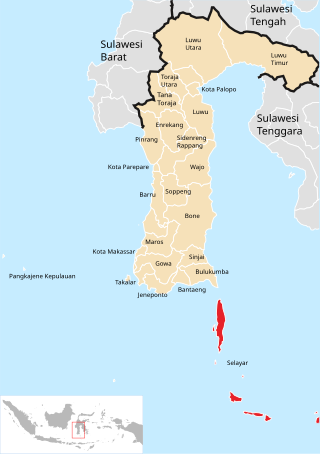
The Selayar Islands Regency is a regency of Indonesia in South Sulawesi province that covers the Selayar Islands, which lie southeast of the southern peninsula of Sulawesi. The archipelago consists of the group's main island, which is surrounded by 41 smaller islands around its coast; further to the southeast lies a widespread group of islands, including the smaller but still substantial islands of Pasimassunggu, Pasimarannu and Pasilambena in the far south, and the huge atoll of Takabonerate. The regency covers an area of 1,357.03 km2, and had a population of 103,596 at the 2000 Census, 122,055 at the Census of 2010 and 137,071 as of 2020. The official estimate for mid 2023 was 142,100. The administrative centre is the town of Benteng on Selayar Island. The Selayar Straits separate the regency from Sulawesi island.

Alor Regency is a regency in East Nusa Tenggara (NTT) province of Indonesia. Established in 1958, Alor Regency administers the Alor Archipelago with its seat (capital) in Kalabahi on Alor Island.

Langkat Regency is the northernmost regency of North Sumatra Province in Indonesia. Its administrative centre is the town of Stabat. It has a land area of 6,263.29 km2 and its population was 967,535 at the 2010 Census and 1,030,202 at the 2020 Census; the official estimate as at mid 2023 was 1,066,711 - comprising 538,822 males and 527,889 females. Its population is roughly equivalent to that of Djibouti.

West Bangka Regency is a regency (kabupaten) of Bangka Belitung Islands Province, Indonesia. It comprises the northwestern part of Bangka Island, together with a number of small islands off its coast. The regency covers an area of 2,820.61 km2 and had a population of 175,110 at the 2010 Census, rising to 204,612 at the 2020 census; the official estimate as at mid 2022 was 209,791 - comprising 108,102 males and 101,689 females. The town of Muntok is its regency seat.

Central Bangka Regency is a regency (kabupaten) of the Bangka Belitung Islands Province, Indonesia. It covers an area of 2,155.77 km2 and had a population of 161,075 at the 2010 Census, rising to 198,946 at the 2020 Census; the official estimate as at mid 2022 was 205,510 - comprising 106,340 males and 99,170 females. The town of Koba is its regency seat.
Yapen Islands Regency is a regency (kabupaten) in Papua Province of eastern Indonesia. It covers an area of 2,432.49 km2 (939.19 sq mi), and had a population of 82,951 at the 2010 Census and 112,676 at the 2020 Census; the official estimate as at mid 2023 was 115,056. It comprises an archipelago which lies in Cenderawasih Bay off the north coast of Western New Guinea.
Nagekeo Regency is a regency on the island of Flores in East Nusa Tenggara province of Indonesia, comprising the Nage people in the south and the Keo in the north. It covers an area of 1,377.04 km2 and had a population of 130,120 at the 2010 Census, and 159,732 at the 2020 Census; the official estimate as at mid 2023 was 166,968. The regency was established on 2 January 2007 by separation of the former eastern districts from Ngada Regency; it has its administrative seat (capital) in the town of Mbay on the north coast of Flores. It is bordered to the west by the residual Ngada Regency and to the east by Ende Regency, while to the north is the Flores Sea and to the south is the Savu Sea.

Sitaro Islands Regency is a regency located off the northern extremity of Sulawesi Island in the southern Sangihe Islands, North Sulawesi Province, Indonesia. The regency was formed under Law Number 15 Year 2007 from 2 January 2007, by separation from the Sangihe Islands Regency of which it had previously formed the southern part. The short form of the name is formed from one syllable from each of the names of the three principal islands — Siau, Tagulandang and Biaro.

Meranti Islands is an archipelago, most of which forms a regency (kabupaten) of Riau Province and lies off the eastern coast of the island of Sumatra, Indonesia. It was created on 19 December 2008 by the separating of these large islands from the mainly mainland regency of Bengkalis. The regency comprises the islands of Tebing Tinggi, Rangsang, Padang, and Merbau, together with minor offshore islands, but does not include Bengkalis Island to the north, which is geographically part of the archipelago but remains within Bengkalis Regency. The principal town is Selat Panjang on Tebing Tinggi Island. The regency covers an area of 4,769.53 km2 and had a population of 176,290 at the 2010 Census and 206,116 at the 2020 Census; the official estimate as of mid-2023 was 211,611.

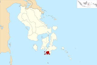
Takalar Regency is a regency of South Sulawesi Province, Indonesia. It covers an area of 566.51 km2 and had a population of 269,603 at the 2010 census and 300,853 at the 2020 census. The official mid-2023 population estimate was 326,044. The entire regency lies within the official metropolitan area of the city of Makassar. The principal towns are at Galesong and Takalar, but the administrative centre is at Pattallassang.

North Minahasa Regency is a regency in North Sulawesi, Indonesia. Its capital is Airmadidi. It was originally part of the Minahasa Regency until it was split off and established as a separate regency on 20 November 2003. It covers an area of 1,059.24 km2, and had a population of 188,904 at the 2010 Census; this had risen to 224,993 at the 2020 Census, and the official estimate as at mid 2023 was 231,791. The Regency includes the offshore islands of Bangka and Talisei to the north of Sulawesi, and Mantenang and Naeng Besar to the northwest.

South Minahasa Regency is a regency in North Sulawesi, Indonesia. Its capital is the town of Amurang. It was originally part of the Minahasa Regency until it was established as a separate regency on 25 February 2003. In turn, nearly four years later, a new Southeast Minahasa Regency was established as a separate regency from part of the South Minahasa Regency on 2 January 2007. The residual Regency now covers an area of 1,456.74 km2, and had a population of 195,553 at the 2010 Census; this had risen to 236,463 at the 2020 Census; the official estimate as at mid 2023 was 244,590.

Southeast Minahasa Regency is a regency in North Sulawesi, Indonesia. It covers a land area of 730.63 km2, and had a population of 100,443 at the 2010 Census; this had risen to 116,323 at the 2020 Census, and the official estimate as at mid 2023 was 118,946. It was established as a separate regency from the south-eastern part of the South Minahasa Regency on 2 January 2007. Its administrative centre is at the town of Ratahan.

Tanimbar Islands Regency is a regency of Maluku province, Indonesia, consisting primarily of the Tanimbar Islands. The Regency covers a land area of 10,102 km2, and it had a population of 105,341 at the 2010 Census and 123,572 at the 2020 Census; the official estimate as at mid 2022 was 124,787. The principal town and administrative centre lies at Saumlaki in Tanimbar Selatan District.

Banggai Sea Regency is a regency in the province of Central Sulawesi, Indonesia. The regency was established on 14 December 2012, partitioned from the Banggai Islands Regency. It comprises the southern part of the Banggai Islands archipelago, including the main island of Banggai itself, the islands of Labobo and Bangkurung to the southwest of Banggai Island, and the numerous small Bokan Islands to the southeast; it does not include the larger island of Peleng to the north which forms the Banggai Islands Regency. The new Banggai Sea Regency covers a land area of 725.67 km2, and the districts now comprising the new Regency had a population of 62,183 at the 2010 Census and 70,435 at the 2020 Census; the official population estimate at mid-2023 was 73,100.
South Buton Regency is a regency located on Buton Island in Southeast Sulawesi Province of Indonesia. This regency was formed from the southern part of Buton Regency, from which it was separated by Act No.16 of 2014, dated 23 July 2014. It covers an area of 546.58 km2, and the population of the districts now comprising the new regency was 74,974 at the 2010 Census and 95,261 at the 2020 Census; the official estimate as at mid 2023 was 101,635. The regency capital is located in Batauga.


