The Bangka Belitung Islands is a province of Indonesia. Situated off the southeastern coast of Sumatra, the province comprises two main landmasses—Bangka and Belitung—and numerous smaller islands. Bangka Belitung is bordered by the Bangka Strait to the west, the Natuna Sea to the north, the Java Sea is to the south and the Karimata Strait to the east. The province's capital and largest city is Pangkal Pinang. Bangka Belitung covers an area of 16,424.06 km2 (6,341.37 sq mi) and has a population of 1,455,678 according to the 2020 census; the official estimate as at mid 2021 was 1,473,165.

Banyuwangi Regency is a regency of East Java province in Indonesia. This regency also known as the sun rise of Java because it is located at the easternmost end of Java Island. It serves as a port between Java and Bali. It is surrounded by mountains and forests to the west; by sea to the east and south. Banyuwangi is separated by the Strait of Bali from Bali. With an area of 5,782.4 km2, this regency is the largest in Java. The regency is a tourist destination, and subject to ongoing development as an international tourist destination with relevant infrastructure. Banyuwangi regency has been declared a taman bumi, or national geological park (Geopark) in 2018.

Bangka is an island lying east of Sumatra, Indonesia. It is administered under the province of the Bangka Belitung Islands, being one of its namesakes alongside the smaller island of Belitung across the Gaspar Strait. The 9th largest island in Indonesia, it had a population of 1,146,581 at the 2020 census. It is the location of the provincial capital of Pangkal Pinang, and is administratively divided into four regencies and a city. The island itself and the surrounding sea suffers considerable environmental damage from its thriving tin mining industry which operates on- and offshore.
Belitung is an island on the east coast of Sumatra, Indonesia in the Java Sea. It covers 4,800.6 km2 (1,853.5 sq mi), and had a population of 309,097 at the 2020 Census. Administratively, it forms two regencies within the province of Bangka-Belitung Islands. The island is known for its pepper and for its tin. It was in the possession of the United Kingdom from 1812 until Britain ceded control of the island to the Netherlands in the Anglo-Dutch Treaty of 1824. Its main town is Tanjung Pandan. The United Nations Educational, Scientific and Cultural Organization has declared 17 tourist attractions in the Belitung Geopark as world geoparks.

The Lingga Regency is a group of islands in Indonesia, located south of Singapore, along both sides of the equator, off the eastern coast of Riau Province on Sumatra island. They are south of the populated Riau Archipelago, known for the industrial island of Batam and the tourist-frequented island of Bintan, although the Lingga Islands themselves are rarely visited due to the infrequent local transportation. The equator goes through the northern tip of Lingga Island, the main island in the archipelago.

Pangkal Pinang is the capital and largest city of the Bangka Belitung Islands Province in Indonesia. It is located on Bangka Island's east coast, the city is divided into seven districts (kecamatan) and has 42 wards (kelurahan).

Merauke Regency is a regency in the far south of the Indonesian province of South Papua. It covers an area of 46,791.63 km2, and had a population of 195,716 at the 2010 Census and 230,932 at the 2020 Census; the official estimate as at mid 2021 was 231,696, comprising 121,078 males and 110,618 female inhabitants. The administrative centre is the town of Merauke; this was projected since 2013 to become an independent city (kota) separate from Merauke Regency, but the alteration has been deferred. It is also the provincial capital of South Papua since 2022. It is the largest regency in Indonesia, with an area of 46,791 km2, slightly larger than Estonia.

Indramayu, named after the God Indra, is a town and district which serves as the capital of Indramayu Regency in the West Java province of Indonesia, and is located in the northern coastal area of West Java, east from Jakarta, north-east from the city of Bandung, and north-west of the city of Cirebon. Most of its land are situated below sea level, which makes the district vulnerable to high tide in stormy conditions. The district is only protected by some dunes and barrages at the seaside.

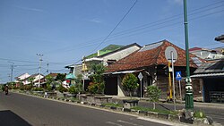
Sungailiat is a city and district (kecamatan) of Bangka Regency, in the Bangka-Belitung province of Indonesia. It is also the regency seat.

Kotabaru Regency is one of the eleven regencies in the Indonesian province of South Kalimantan. It consists of two parts; the smaller but more populated part comprises Laut Island, the largest island off the coast of Kalimantan, together with the smaller Sebuku Island off Laut Island's east coast and even smaller islands nearby; the larger but less populated part consists of districts on the mainland of Kalimantan. The regency has an area of 9,442.46 km2, and had a population of 290,142 at the 2010 Census and 325,622 at the 2020 Census. The official estimate as at mid 2021 was 329,483. The regency seat is located at the large town of Kotabaru at the northern tip of Laut Island.

Sorong Regency is a regency of Southwest Papua province of Indonesia. It covers an area of 13,075.28 km2, and had a population of 70,619 at the 2010 Census, and 118,679 at the 2020 Census; the official estimate as at mid 2021 was 121,963. Its administrative centre is the town of Aimas. Sorong Regency surrounds Sorong City (Kota) on the landward side; the city is administratively independent of the Regency; Sorong City has an airport, Sorong Airport, which also serves the Regency.

South Barito Regency is a regency in Central Kalimantan province of Indonesia. The regency seat is located in town of Buntok, located in South Dusun district. The population of South Barito Regency was 124,128 at the 2010 Census and 131,100 at the 2020 Census; the official estimate as at mid 2021 was 131,606.

Malinau Regency is a regency of North Kalimantan Province in Indonesia. The administrative centre is the town of Malinau. The regency is home to the Kayan Mentarang National Park. It covers an area of 40,088.38 km2, and had a population of 62,423 at the 2010 Census and 82,510 at the 2020 Census; the official estimate as at mid 2021 was 83,796. It is the regency with the largest area in the province, as well as the least densely populated. Other than that, Malinau is the only regency in North Kalimantan that is predominantly Protestant and the second most-developed region in North Kalimantan after Tarakan in terms of Human Development Index.

Waisai is a town in the south of the island of Waigeo in the Raja Ampat Islands, Indonesia. Founded in 2003, it is the capital of the Raja Ampat Regency and is home to a little over 8,000 people. It is a transit point for tourists visiting the rest of the archipelago, and its airport is reachable by plane from the larger cities of Manado and Sorong, or ferry from the latter. While it is mainly a stopping point for tourists before continuing to the rest of the islands, the town includes a dive resort, several accommodations, and two beaches.
Chinese Indonesians have lived in Bangka Belitung Islands, Indonesia for centuries. Bangka Belitung is one of the regions with the largest Chinese population in Indonesia besides Java, Riau, Eastern Sumatra and West Borneo.
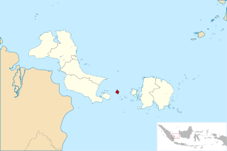
Pongok, sometimes known as Liat, is an Indonesian island which is part of the Pongok Islands District of the South Bangka Regency, Bangka Belitung Province. It comprises over 95% of the district's area and most of its population, with an area of 48.3 square km. It is the 5th largest island in the province, being far smaller than Bangka and Belitung in addition to the islands of Lepar and Mendanau.

Belinyu is a town and district (kecamatan) of Bangka Regency, in the Bangka-Belitung province of Indonesia. The district is located on the northern tip of Bangka Island.

Tukak Sadai is a district of South Bangka Regency, Bangka-Belitung Islands. The district is located in the southeastern section of Bangka Island, and contains the Sadai seaport.
Air Gegas is a district of South Bangka Regency, Bangka-Belitung Islands. It is the second largest and second most populated district in the regency after the regency seat of Toboali.
Sungai Selan is a district (kecamatan) of Central Bangka Regency, in the Bangka-Belitung province of Indonesia.