South Casco, Maine | |
---|---|
Village | |
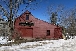
Mars in Sol Gallery | |
Coordinates: 43°54′53″N70°31′04″W / 43.91472°N 70.51778°W Coordinates: 43°54′53″N70°31′04″W / 43.91472°N 70.51778°W | |
Country | United States |
State | Maine |
County | Cumberland |
Elevation | 315 ft (96 m) |
Time zone | Eastern (EST) (UTC-5) |
• Summer (DST) | EDT (UTC-4) |
ZIP code | 04077 |
Area code(s) | 207 |
GNIS feature ID | 575828 [1] |
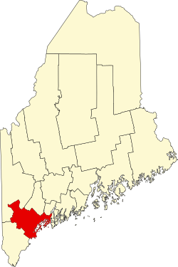
South Casco is an unincorporated village in the town of Casco, Cumberland County, Maine, United States. The community is located along U.S. Route 302 and Maine State Route 35 near the town's border with Raymond and the north shore of Sebago Lake. South Casco has a post office with ZIP code 04077. [2] [3]
In law, an unincorporated area is a region of land that is not governed by a local municipal corporation; similarly an unincorporated community is a settlement that is not governed by its own local municipal corporation, but rather is administered as part of larger administrative divisions, such as a township, parish, borough, county, city, canton, state, province or country. Occasionally, municipalities dissolve or disincorporate, which may happen if they become fiscally insolvent, and services become the responsibility of a higher administration. Widespread unincorporated communities and areas are a distinguishing feature of the United States and Canada. In most other countries of the world, there are either no unincorporated areas at all, or these are very rare; typically remote, outlying, sparsely populated or uninhabited areas.
Casco is a town in Cumberland County, Maine, United States. The population was 3,742 at the 2010 census. Casco includes the villages of Casco, South Casco and Cook Mills. The town borders the east shore of Sebago Lake, and is home to part of Sebago Lake State Park. Casco is part of the Portland–South Portland–Biddeford, Maine metropolitan statistical area. Casco is just under 30 miles (48 km) from downtown Portland.
Cumberland County is a county in the U.S. state of Maine. As of the 2010 census, the population was 281,674, making it the most populous county in Maine. Its county seat is Portland. Cumberland County was founded in 1760 from a portion of York County, Massachusetts and named for William, Duke of Cumberland, a son of King George II.
Portage is an unincorporated village within the town of Portage Lake in Aroostook County, Maine, United States. The community is located on Maine State Route 11 and the southeast shore of Portage Lake 10 miles (16 km) north-northwest of Ashland. Portage has a post office with ZIP code 04768, which opened on November 6, 1883.
Fort Kent Mills is an unincorporated village in the town of Fort Kent, Aroostook County, Maine, United States. The community is located on Maine State Route 11 and the Fish River south of the village of Fort Kent. Fort Kent Mills has a post office with ZIP code 04744, which opened on April 11, 1906.
Saint David is an unincorporated village in the town of Madawaska, in Aroostook County, Maine, United States. The community is located on U.S. Route 1 in the Saint John River Valley, 4.5 miles (7.2 km) east of the village of Madawaska. Saint David has a post office with ZIP code 04773.
Smyrna Mills is an unincorporated village in the town of Smyrna, in Aroostook County, Maine, United States. The community is located on U.S. Route 2 near Interstate 95, 15.5 miles (24.9 km) west of Houlton. Smyrna Mills has a post office with ZIP code 04780.
West Rockport is an unincorporated village in the town of Rockport, Knox County, Maine, United States. The community is located at the junction of Maine State Route 17 and Maine State Route 90, 3 miles (4.8 km) west of the Rockport town center. West Rockport has a post office with ZIP code 04865.
China Village is an unincorporated village in the town of China, Kennebec County, Maine, United States. The community is located at the junction of U.S. Route 202, Maine State Route 9, and Maine State Route 137 7.6 miles (12.2 km) southeast of Waterville. China Village has a post office with ZIP code 04926. Most of the village is part of the China Village Historic District, added to the National Register of Historic Places in 1977.
East Newport is an unincorporated village in the town of Newport, Penobscot County, Maine, United States. The community is located at the junction of U.S. Route 2, Maine State Route 7, and Maine State Route 100 3.2 miles (5.1 km) east-southeast of the community of Newport. East Newport has a post office with ZIP code 04933.
East Vassalboro is an unincorporated village in the town of Vassalboro, Kennebec County, Maine, United States. The community is located along Maine State Route 32 7.3 miles (11.7 km) south of Waterville. East Vassalboro has a post office with ZIP code 04935.
Farmington Falls is an unincorporated village in the town of Farmington, Franklin County, Maine, United States. The community is located along the Sandy River 5 miles (8.0 km) southeast of the village of Farmington; U.S. Route 2, Maine State Route 27, Maine State Route 41, and Maine State Route 156 all pass through the village. Farmington Falls has a post office with ZIP code 04940.
North Vassalboro is an unincorporated village in the town of Vassalboro, Kennebec County, Maine, United States. The community is located on Maine State Route 32 4.5 miles (7.2 km) south of Waterville. North Vassalboro has a post office with ZIP code 04962, which opened on March 22, 1828.
Oquossoc is an unincorporated village in the town of Rangeley, Franklin County, Maine, United States. The community is located at the junction of Maine State Route 4 and Maine State Route 17 at the northwest tip of Rangeley Lake. Oquossoc has a post office with ZIP code 04964, which opened on December 17, 1902.
Sandy Point is an unincorporated village in the town of Stockton Springs, Waldo County, Maine, United States. The community is located along U.S. Route 1 on the west bank of the Penobscot River estuary, 4.1 miles (6.6 km) south of Bucksport. Sandy Point has a post office with ZIP code 04972, which opened on January 1, 1795.
Shawmut is an unincorporated village in the town of Fairfield, Somerset County, Maine, United States. The community is located along U.S. Route 201 and the Kennebec River, which is dammed at the village; it is 11.5 miles (18.5 km) south-southeast of Skowhegan. Shawmut has a post office with ZIP code 04975.
Bar Mills is an unincorporated village in the town of Buxton, York County, Maine, United States. The community is located along the Saco River at the junction of state routes 4A and 112. Bar Mills has a post office with ZIP code 04004.
Center Lovell is an unincorporated village in the town of Lovell, Oxford County, Maine, United States. The community is located along Maine State Route 5 near the east bank of the Kezar River. Center Lovell has a post office with ZIP code 04016, which opened on May 9, 1848.
East Parsonsfield is an unincorporated village in the town of Parsonsfield, York County, Maine, United States. The community is located along Maine State Route 160 near the town's eastern border with Cornish. East Parsonsfield has a post office with ZIP code 04028.
East Waterboro is an unincorporated village in the town of Waterboro, York County, Maine, United States. The community is located at the junction of U.S. Route 202, Maine State Route 4, and Maine State Route 5. East Waterboro has a post office with ZIP code 04030.
Sebago Lake is an unincorporated village in the town of Standish, Cumberland County, Maine, United States. The community is located on the south shore of its eponymous lake at the junction of Maine State Route 35 and Maine State Route 114. Sebago Lake has a post office with ZIP code 04075.
South Freeport is an unincorporated village in the town of Freeport, Cumberland County, Maine, United States. The community is located on Casco Bay 2.6 miles (4.2 km) south of the village of Freeport. South Freeport has a post office with ZIP code 04078.
Dryden is an unincorporated village in the town of Wilton, Franklin County, Maine, United States. The community is located along U.S. Route 2, Maine State Route 4, and Maine State Route 156 6.5 miles (10.5 km) south-southwest of Farmington. Dryden has a post office with ZIP code 04225, which opened on January 30, 1899.
This Maine state location article is a stub. You can help Wikipedia by expanding it. |