South Denver, Colorado

Last updated

South Denver
Former city
Platt Park and Fleming House.jpg
Former town hall in modern Platt Park
USA Colorado location map.svg
Red pog.svg
South Denver
Location within the state of Colorado
Coordinates: 39°40′42″N104°57′44″W / 39.67833°N 104.96222°W / 39.67833; -104.96222
Country United States
State Colorado
County Arapahoe (historic)
Denver (modern day)
Established1881
Incorporated August 9, 1886
Annexed by DenverFebruary 7, 1894
Demonym South Denverite [1]
Time zone UTC-7 (Mountain (MST))
  Summer (DST) UTC-6 (MDT)

South Denver was an incorporated city in Colorado incorporated in 1886 and annexed by Denver in 1894. Covering almost 12 square miles that included the former site of Montana City, the South Denver community was established by James Fleming in 1881 as an alcohol-free community. Potato farmer Rufus "Potato" Clark led a group which donated land to allow the University of Denver to relocate to the area and escape the "moral and environmental pollution" of Denver. Incorporated as a town to enable the community to enforce vice laws, its anti-alcohol regulations surviving the city's dissolution. John Evans, the former Colorado governor, contributed to the community's development by fostering the establishment of the two Methodist-organized subdivisions of University Park Colony and Evanston.

Contents

Under duress from the 1893 Silver Panic, South Denver became one of many communities absorbed by Denver during the 1890s. Portions of the townsite now comprises the Denver neighborhoods of University and University Park.

History

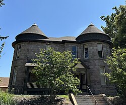
In 1881, James Fleming established the South Denver community to serve as a "dry" Denver suburb. Fleming, a young man who had made his wealth in the Pennsylvanian oil industry, sold much of what he owned in the area to permit the community to have transportation and residential development. In the center of the land he kept, Fleming constructed a Queen Anne-style home at 1520 Grant Street. [2]

Though the area that comprised the area known as "South Denver" or the "South Side" was poorly defined in the 20 years following the 1860 establishment of Denver, [3] the community of South Denver's formal boundaries were Alameda and Yale Avenues to the north and south respectively and Colorado Boulevard to the South Platte River from east to west. In all, the community's almost 12-square-mile area made it the largest of Denver's suburbs. [4] South Denver included the former site of Montana City, a community established during 1858 Pikes Peak Gold Rush and the first settlement in the Denver area. [5]

A municipal incorporation effort was organized by Fleming, Rufus Clark, and Avery Gallup in early 1886 in response to the saloons, dance halls, and gambling establishments near a racetrack Denver's Overland Park, to allow the area to legally enforce anti-vice laws. With help from others, the group created a petition and approached the 150 residents of the area in search of the 30 votes needed to establish the community. [6] The effort was backed by nonresident property owners William A. H. Loveland and Theodore C. Henry, both owners of the Denver Circle Real Estate Company, and Charles L. McIntosh on behalf of interests in the Denver Circle Railroad Company. However, a pro-legal alcohol lobby known as the "liquor element" and 13 nonresident landowners moved against incorporation. [7]

Forty signers filed the relevant documents in Arapahoe County court on June 16, 1886. Clark and four other men were appointed commissioners by the court to clerk the incorporation election to occur six weeks later. Saloon keeper Joe Lowe and other anti-prohibitionists campaigned against the incorporation effort but lost the July 31 election, which was decided by 65 votes for incorporation and 38 against (one ballot was left blank). The Arapahoe County court declared South Denver an incorporated town on August 9. [8] Fleming was elected mayor, Gallup was elected as one of five trustees, and Clark was elected treasurer in the September 4 city election; each were elected for a one-year term and presented an salary of $1 per term. Fleming and Clark were reelected to their posts on April 1, 1887. [9]

The anti-incorporation nonresident landowners, led by former Rocky Mountain News owner William Byers, hired a law firm and filed a suit in the Arapahoe County district court on November 27, 1886, claiming that the incorporation of South Denver was done illegally. The suit was again filed in the Colorado Supreme Court after its dismissal in the district court; the suit was again dismissed there on December 23, 1887. [10]

Fleming was South Denver's first and only mayor, selling his still-surviving home to serve as South Denver's town hall during his mayoral tenure. The mansion also served as a library until 1913 and a jail. [11] A lumberyard, named Fleming Brothers, opened by Fleming's cousins–Jesse, Calvin, and D. Carson–erected many of the town's homes with the ease of a shoemaker making shoes, per the community's newspaper, Denver Eye. [12]

South Denver suffered as the 1893 Silver Panic in Denver shrank real estate values. Further exacerbating the trouble was the town's small population, large area, and growing debts. Much of South Denver's debts had accrued during the creation of a city water system, which was severely dilapidated by 1894. Despite desires to remain independent from their larger neighbor, financial considerations and slowing population growth spurred voters in South Denver to approve annexation by Denver in a 288–100 vote on January 30, 1894. Some voters had been convinced by Methodist Bishop Henry White Warren's promise that area would remain alcohol-free post-annexation. The annexation was implemented on February 7, 1894, with Denver taking on South Denver's $263,000 debt. [13] Fleming's former home and the block on which it was constructed were included in the annexation as a public property and were renamed as "Platt Park" for James H. Platt Jr., a politician and businessman who drowned while fishing near Georgetown in June 1894. [14]

University Park Colony and Evanston

John Evans, former Colorado territorial governor, had established the University of Denver as the Colorado Seminary in Denver's downtown in 1864, near the site of the modern Boettcher Concert Hall. [15] As the city grew, this Methodist campus was increasingly surrounded by urban influences. Elizabeth Iliff Warren, then-widow of John Wesley Iliff and wife of Bishop Warren, announced on June 18, 1884, that she would donate $100,000 for the university to open a theology graduate school on the condition that the university move its campus from its "unsavory" site to a more academically conducive space. [16] Elizabeth Warren's donation came with the further stipulation that an additional $50,000 be raised to support the new theological school; a condition university chancellor David Hastings Moore fulfilled. Evans led the search for a new campus site that followed, with several locations around Denver considered–including the later site of Stapleton International Airport. [17]

During the latter 19th century, potato farmer Rufus "Potato" Clark exerted significant influence on the southern corridor out of Denver. Clark, a heavy drinker prior to arriving in Colorado with his family in 1859, had been converted during an Denver tent revival by the United Brethren and was engaged in a variety of charitable ventures. [18] Though not a Methodist, Clark was approached in 1884 about supporting university's move and offered 40 acres of his land as a donation in what was then Arapahoe County. [19] After raising the donation to 80 acres of his property and securing commitments in property and money from other landowners in the area, the university accepted Clark's offer. An additional 320 acres was purchased adjacent to Clark's donation for $75 an acre in 1886, bringing the university's holdings in the area to 400 acres. [20]

Clark conditioned this donation on the premises that the community would be laid out in a tree-lined grid and that the sale and production of alcohol would be prohibited, thereby avoiding replicating Denver's "moral and environmental pollution". [21] In portions of South Denver not gifted by Clark, the town priced liquor licenses at $3,500 per year, pricing out most alcohol-related ventures. [22] The site provided an elevated view of 50 miles along the Front Range but was very rural; an early resident would later recall that rabbits and coyotes outnumbered people in the community for years. [23] The land secured, it was announced the university would move "perhaps in two years, perhaps in seven" to the location now being called "University Park". [24]

A quarter of the university's South Denver property was set aside in 1886, while the remainder were to be sold as 2,500 lots priced at between $300 and $1,400 a pair. [25] Seeking to interest the Denver Methodist population, the Colorado Conference of the Methodist Episcopal Church described the future university location as beautiful and connected by rail in 1887. [26] The first home built in University Park home was at 2525 Evans for university trustee J. H. Clough in 1886, followed one at 2184 S. Milwaukee for the Warrens. [27] On November 26, 1887, Clark established the Evanston Real Estate and Trust Company. Clark platted a portion his property on the campus land as the Evanston subdivision, which was between modern Jewell and Iliff Avenues from north to south and Race and Downing from east to west. Here, he installed fencing around each lot and planted trees for shade. As with University Park's deeds, Clark introduced language lifted from Union Colony's deeds to prohibit the production and sale of alcohol in Evanston. [28]

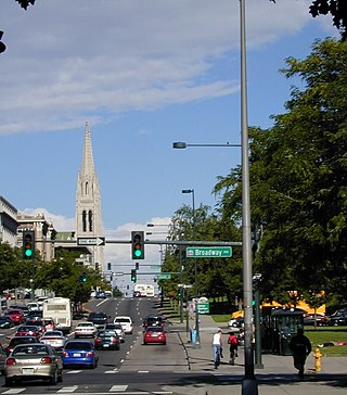
On April 16, 1888, the Methodist Episcopal Church's Colorado Conference held a meeting in Trinity Methodist Episcopal Church. The meeting included Evans and former Union Colony president Robert A. Cameron, as well as other former Union Colony officials. the University Park Colonization Society was established to held develop University Park and Evanston "into a formal Methodist prohibition suburb". Evans was appointed the organizer for the society during the meeting and Cameron became the society's president. Evans had experience in similar projects, having helped establish Evanston, Illinois, and Northwestern University. [29] Additionally, Evans had invested in the Denver and New Orleans Railroad, which had built track through the area before reorganizing as the Colorado and Southern Railway, meaning he possessed property in the area. [30] The society promised that misfortunes experienced in Evanston, Illinois, and at Union Colony in Greeley would not be repeated. [31]

Evans opened a store and office building in 1888 to spur development in the area. [32] Evans's office building housed the University Park Market from 1890 until 1968 and was the community's first post office. [33] By 1894, it also housed University Park's first Sunday school. [34] The building survives at its original location on the northeast corner at the intersection of Evans Avenue and Milwaukee Street as a real estate office. [35] A Methodist church was incorporated in University Park on September 16, 1894, with 56 charter members; the congregation would meet at chapels on the University of Denver's campus until building their own chapel in 1926–1927. [36]

Legacy

In 1899, Clark sold 2,050 lots in Evanston to the university for $110,000 despite the lots being appraised at a value of $250,000–Clark stipulated that these lots be sold for a profit. Clark sold his remaining share of Evanston to William C. Johnston for $60,000 the same year; Clark used the proceeds from these sales to alleviate some of the University of Denver's debts and to rebuild a theological school named for Clark and his wife in Shenge, Sierra Leone. Despite Johnston's efforts to revive the area as an "elite, cultured university town", the concept of Evanston becoming a "Methodist colony" soon died. [37]

Portions of what was once South Denver now encompass the adjacent University and University Park neighborhoods of Denver. As of 2016, some former areas of South Denver such as the University neighborhood had mortgages which retained the old covenants prohibiting alcohol sale and production. [38]

Related Research Articles

<span class="mw-page-title-main">Denver</span> Capital of Colorado, United States

Denver is a consolidated city and county, the capital, and most populous city of the U.S. state of Colorado. Its population was 715,522 at the 2020 census, a 19.22% increase since 2010. It is the 19th-most populous city in the United States and the fifth most populous state capital. It is the principal city of the Denver–Aurora–Lakewood, CO Metropolitan Statistical Area and the first city of the Front Range Urban Corridor.

<span class="mw-page-title-main">Arapahoe County, Colorado</span> County in Colorado, United States

Arapahoe County is a county located in the U.S. state of Colorado. As of the 2020 census, its population was 655,070, making it the third-most populous county in Colorado. The county seat is Littleton, and the most populous city is Aurora. The county was named for the Arapaho Native American tribe, who once lived in the region.

<span class="mw-page-title-main">University of Denver</span> Private university in Denver, Colorado, US

The University of Denver (DU) is a private research university in Denver, Colorado. Founded in 1864, it is the oldest independent private university in the Rocky Mountain Region of the United States. It is classified among "R1: Doctoral Universities – very high research activity". DU enrolls approximately 5,700 undergraduate students and 7,200 graduate students. The 125-acre (0.51 km2) main campus is a designated arboretum and is located primarily in the University Neighborhood, about five miles (8 km) south of downtown Denver. The 720-acre Kennedy Mountain Campus is located approximately 110 miles northwest of Denver, in Larimer County.

<span class="mw-page-title-main">Auraria, Denver</span> Early neighborhood in Denver, Colorado

Auraria was a small mining settlement in the Kansas Territory in the United States. Today it survives in its original location as a neighborhood of Denver, Colorado, south of the confluence of Cherry Creek and the South Platte River.

<span class="mw-page-title-main">John Evans (Colorado governor)</span> American politician

John Evans was an American politician, physician, founder of various hospitals and medical associations, railroad promoter, governor of the territory of Colorado, and namesake of Evanston, Illinois; Evans, Colorado; and formerly Mount Evans, Colorado.

<span class="mw-page-title-main">Iliff School of Theology</span> American Methodist seminary

Iliff School of Theology is a graduate Methodist theological school in Denver, Colorado. Founded in 1892, the school's campus is adjacent to the University of Denver. Fewer than 200 students attend the school.

<span class="mw-page-title-main">Park Hill, Denver</span> Neighborhood in Denver, Colorado, United States of America

Park Hill is a neighborhood in Denver, Colorado, U.S. Located in the northeastern quadrant of the city, it is bordered by Colorado Boulevard on the west, East Colfax Avenue on the south, Quebec Street on the east, and East 52nd Avenue on the north. The entire Park Hill neighborhood is located in the area known as East Denver. It is further divided by the City and County of Denver into three administrative neighborhoods, South Park Hill, North Park Hill, and Northeast Park Hill.

<span class="mw-page-title-main">Cherry Creek, Denver</span> Neighborhood in Denver, Colorado

Cherry Creek is a neighborhood in Denver, Colorado, in the United States. It has many newer residences mixed in with some of Denver's older homes.

<span class="mw-page-title-main">Littleton, Colorado</span> City in Colorado, United States

Littleton is a home rule municipality city located in Arapahoe, Douglas, and Jefferson counties, Colorado, United States. Littleton is the county seat of Arapahoe County and is a part of the Denver–Aurora–Lakewood, CO Metropolitan Statistical Area. The city population was 45,652 at the 2020 United States Census, ranking as the 20th most populous municipality in the State of Colorado.

<span class="mw-page-title-main">Street system of Denver</span>

The oldest part of Denver, Colorado, now the neighborhoods of Auraria Campus, LoDo, much of downtown, and Five Points, is laid out on a grid plan that is oriented diagonal to the four cardinal directions. The rest of the city, including the eastern part of downtown, is laid out primarily on a grid oriented to the cardinal directions. In this larger grid, from east to west, there are generally 16 city blocks per mile, except between Zuni Street and Lowell Boulevard in west Denver. From north to south, there are typically eight blocks per mile, although there are many areas with more blocks per mile. Addresses follow a decimal system, with addresses advancing by one hundred at each cross street.

<span class="mw-page-title-main">Hygiene, Colorado</span> Unincorporated community in Boulder County, Colorado

Hygiene is an unincorporated community with a U.S. Post Office in Boulder County, Colorado, United States. Application for the first Hygiene Post Office was made by Jacob Stoner Flory of the United Church of the Brethren on May 28, 1883. Originally named Pella, the community's present name stems from a time when it had a sanatorium to work with tuberculosis patients. St. Vrain Church of the Brethren, a historic Church of the Brethren congregation, is located in the town.

<span class="mw-page-title-main">Jacob Downing</span> American judge

Jacob Downing was a major in the Union Army during the American Civil War. He was present at the infamous Sand Creek Massacre as a subordinate of Colonel John Chivington. After the war ended, he played a part in the development of Colorado and in particular the city of Denver.

<span class="mw-page-title-main">Evans Memorial Chapel</span> Oldest continuously-used religious building in Denver

The Evans Memorial Chapel is an historic chapel on the campus of the University of Denver in Colorado. It is the oldest continuously-used building for religious purposes in Denver. Completed in 1878, the Evans Memorial Chapel was built with patronage by John Evans in honor of his daughter Josephine. Evans was governor of the Colorado Territory and a founder of the Colorado Seminary. Once part of Grace Church, a prominent Methodist Episcopal congregation on 13th Avenue and Bannock in downtown Denver, the small Gothic Revival chapel was moved to the University of Denver's campus in 1959. It reopened there in April 1960, and is now the campus's oldest building. It currently serves as an interdenominational chapel and wedding venue.

<span class="mw-page-title-main">Outline of Colorado</span> Overview of and topical guide to Colorado

The following outline is provided as an overview of and topical guide to the U.S. state of Colorado:

<span class="mw-page-title-main">Chaffee Park, Denver</span> Neighborhoods in Denver in Colorado, United States

Chaffee Park is a neighborhood in Denver, Colorado located in the northwest corner of the city. Chaffee Park is north of Sunnyside connected via Zuni Street, and northeast of Berkeley connected through Regis via nearby Lowell Boulevard. Chaffee Park is east of Regis and south of Adams County.

Shenge is a coastal fishing town along the Atlantic Ocean in Moyamba District, Southern Province, Sierra Leone. Shenge is the seat of the Kagboro Chiefdom, part of the third level of administration. The dense coastal jungle has prevented development of a good road network, and the Shenge is still most easily reached by boat. The local small fishing and passenger boats that travel among the coastal towns are known as pampas in Sierra Leone.

<span class="mw-page-title-main">William Gray Evans</span>

William Gray Evans was the oldest son of Colorado's second territorial governor, John Evans and Margaret Gray Evans. He was president of the Denver Tramway Company. He oversaw the completion of the Moffat Tunnel and worked for four years on the City Beautiful project of Mayor Robert Walter Speer. He owned the Byers-Evans House, now the Byers-Evans House Museum, which is listed on the National Register of Historic Places.

<span class="mw-page-title-main">Margaret Gray Evans</span>

Margaret Gray Evans was the wife of Territorial Governor John Evans and was a philanthropist. She arrived in Denver when it was a rough city, having grown up in a privileged home in Maine. Evans was First Lady of Colorado for her husband and her son-in-law, Samuel Hitt Elbert, who was a widower when he became governor. She was known for creating Denver society for the manner in which she entertained in what was the executive manor in Colorado. She assisted her husband on his educational and civil projects, and created her own. She founded the Denver Orphan's Home and was involved in the establishment of literary and charitable organizations. She was also active on boards of the University of Denver. She was the mother of William Gray Evans and Anne Evans.

<span class="mw-page-title-main">Rufus Clark</span> American pioneer and businessman (1822–1910)

Rufus Clark, also known both as Potato Clark and Dad Clark, was an American pioneer, businessman, politician, and community leader who was dubbed the "Potato King of Colorado". Born in Connecticut, Clark spent time at sea and searching for gold in Australia and California before migrating to Denver from Iowa in 1859 with his second wife and their child during the Pike's Peak Gold Rush. Clark established a 160-acre farm along the South Platte River, acquiring a fortune and substantial landholdings from selling potatoes to miners and Denverites. After his second wife died in 1861, he was elected to the Colorado territorial legislature in 1864 for a single term.

References

Citations

Sources

  • Anstey, Mary Therese. "The Fall & Rise of the Queen City of the Plains, 1893-1904" (PDF). Discover Denver. Retrieved August 10, 2023.
  • "Bishop Flickinger Coming". Rocky Mountain News . Vol. 51, no. 307. Denver. November 3, 1910. p. 5. Retrieved October 7, 2023 via Colorado Historic Newspaper Collection.
  • Etter, Don D. (1974). University Park, Denver: Four Walking Tours. Graphic Impressions, Incorporated via Denver Public Library.
  • Fetter, Rosemary (2016). From Stage Trail to Light Rail: The Dynamic Denver South Corridor. Virginia Beach, VA: The Donning Company Publishers. ISBN   9781578649945.
  • Fisher, Steven (2012). A Brief History of South Denver & University Park. Charleston, SC: The History Press.
  • Fisher, Steven (March 1, 2006). "DU's rural roots". University of Denver Magazine. Denver: University of Denver . Retrieved August 6, 2023.
  • Goodstein, Phil (1991). South Denver Saga. Denver: New Social Publications.
  • Jensen, Kelly (November 3, 2016). "The DU neighborhood: classic beauty and college vibes". KUSA . Retrieved October 8, 2023.
  • Leonard, Stephen J.; Noel, Thomas J. (2016). A Short History of Denver. Reno, NV: University of Nevada Press. ISBN   978-1-943859-19-1.
  • Templin, J. Alton (1977). "Metropolitan Denver, 1884–1912". In Templin, J. Alton; Breck, Allen D.; Rist, Martin (eds.). The Methodist, Evangelical, and United Brethren Churches in the Rockies, 1850–1976. Denver: Rocky Mountain Conference of the United Methodist Church.
  • "University Park Neighborhood History". history.denverlibrary.org. Denver: Denver Public Library . Retrieved August 10, 2023.
  • Denver Department of Planning & Community Development (September 8, 2008). University Park Neighborhood Plan (PDF). Denver: City and County of Denver.
  • Van Wyke, Millie (1991). The Town of South Denver: Its People, Neighborhoods and Events Since 1858. Boulder, CO: Pruett Publishing Company. ISBN   0-87108-813-4.