South Norwalk

Last updated

South Norwalk
Taxing District
SoNo Signage.jpg
SoNo illuminated sign
USA Connecticut location map.svg
Red pog.svg
South Norwalk
Usa edcp location map.svg
Red pog.svg
South Norwalk
Coordinates: 41°07′N73°25′W / 41.11°N 73.42°W / 41.11; -73.42
Country Flag of the United States.svg United States
State Flag of Connecticut.svg  Connecticut
County Fairfield
City Norwalk
FoundedAugust 18, 1870
Incorporated with NorwalkJune 6, 1913
ZIP code
06854
Area code(s) Area codes 203 and 475

South Norwalk is a neighborhood and the Second Taxing District [1] [2] in Norwalk, Connecticut. The neighborhood was originally a settlement called 'Old Well' which became chartered as the city of 'South Norwalk' on August 18, 1870. The cities of Norwalk and South Norwalk were incorporated on June 6, 1913. The neighborhood is often referred to with the acronym 'SoNo' [3] .

Contents

South Norwalk is a diverse neighborhood both from a socioeconomic and racial perspective. Recent redevelopment is bringing new modern and affordable housing, a boutique hotel, and new businesses. The area provides one of the most attractive locales for industrial and other businesses within its confines. Families continue to move into South Norwalk for its competitive public school district and affordable real estate.

South Norwalk is host of the annual SoNo Arts Celebration, as well as the famed annual Oyster Festival. The SoNo Arts Fest is a free event that takes place every August and features over 100 fine art and craftsperson exhibits, as well as over 25 musical performances for all ages. The annual Oyster Festival, sponsored by the Norwalk Seaport Association, is an integral part of the culture of Norwalk, and has evolved into a community service event where over $200,000 is raised by various community groups to be distributed throughout the region in fulfillment of their mission to revitalize the harbor and preserve Norwalk's maritime heritage. [4]

Boundaries

South Norwalk, or Norwalk 2nd Taxing District, borders are as follows: [5]

History

Map of South Norwalk and Norwalk, CT South Norwalk and Norwalk, Conn. (2674626278).jpg
Map of South Norwalk and Norwalk, CT

Old Well

"Sailing ships in the olden days pulled up to docks along the inner harbor and waited their turn to fill up their water casks from the “Old Well”. In a 1738 deed Washington Street is referred to as “the highway that leads to ye landing place called Ye Old Well. The actual well is shown on the Beers Atlas map of 1867 [6] to be East of Water Street about 75 feet South of Washington Street. The exact location has been lost but is believed to have been very near to Donovan’s Tavern, which seems likely since sailors are said to have enjoyed the spirits. Old Well was involved in coastal trade, manufacturing, and shipbuilding as well as having many farms with diversified crops." [7]

“Old Well was scarcely a village in those days, but rather a group of farms, and the well which gave the place its name was on Water street, near the corner of Haviland street, on the property of Eliakim Raymond, a patriarch of several Norwalk lines. His house stood at the corner of Washington and Water streets before the Revolution and was burned with rest of the town." [8]

City of South Norwalk

"Norwalk was made a borough in 1836, and the village of Old Well, named from an ancient well where vessels were supplied with water, was incorporated into a city in 1868, and named South Norwalk two years afterward." [9] "South Norwalk, formerly called "Old Well" was organized a city August 18, 1870, under a charter granted by the Legislature of Connecticut, July 5 of the same year. This charter was revised by the Legislature April 19, 1882, and the city continued its existence under this revised charter until May 27, 1897, when the Legislature approved a revised and amended charter, under which the city has since continued and worked." [8] [10]

"In the 1800s, industrialization started to take place--large factories manufacturing goods such as firearms, buttons, shoes, cloth and hats were increasing in Connecticut and in Norwalk. Workers came up from Chesapeake, Maryland, to work as oystermen. Wealthy owners and managers of businesses lived on Golden Hill overlooking South Norwalk. Immigrants came into Norwalk from many places. One of the largest [group] to come here in the early 1900s was the Hungarians; there were also many Eastern European Jews and Italians, among others." [11]

"In the city government consolidation of 1913, the City of South Norwalk became the Second Taxing District, but South Norwalk was brought into the consolidation against its will. South Norwalk had been incorporated in 1873 as a city within the Town of Norwalk and in the following half-century it became the economic center of Norwalk. With a port and a railroad, it was the center of Norwalk industry, providing employment to thousands of Norwalk factory workers.

"Prosperous and self-sufficient, the City of South Norwalk had little financial incentive to join in the 1913 consolidation. Its residents feared higher taxes if they lost their city status. In 1902 South Norwalk had tried to leave the Town of Norwalk entirely, and, along with East Norwalk, become a completely separate Town. At the time Mayor Mortimer M. Lee said that South Norwalk had “a large water system, a splendid electric light plant, a separate sewer system, a public library and a library building and schools second to none.” In 1903 the Connecticut State legislature passed a bill to create the independent Town of South Norwalk, but it was vetoed by the governor." [12] (Abiram Chamberlain) [13]

The SoNo Collection

The SoNo Collection is a 700,000 square foot mall located next to Interstate 95 and Route 7 that was opened in October 2019. It was built by Brookfield Properties Retail Group and is the fourth mall in the Fairfield County. It features southern Connecticut’s only Nordstrom and Bloomingdales’s. [14] [15]

National Register of Historic Places

Canaan Institutional Baptist Church Canaan Institutional Baptist Church 002.JPG
Canaan Institutional Baptist Church
Former City Hall NorwalkCTNorwalkMuseum80122007.JPG
Former City Hall

The Norwalk Historical Society along with the Norwalk Historical Commission reopened the Norwalk Historical Society Museum at the Lockwood House at 141 East Avenue. The archives, genealogy and unframed photographs was placed with the “History Room” at the Norwalk Public Library Main branch (1 Belden Ave, Norwalk, CT). It includes items from the four collections: City of Norwalk, Lockwood family, Norwalk Historical Society and the Connecticut Daughters of the American Revolution (DAR) and Norwalk-Village Green Chapter. [19]

Norwalk River Railroad Bridge NorwalkCTNorwalkRivRRBridge08122007.JPG
Norwalk River Railroad Bridge

Emergency services

The Norwalk Police Department [22] is located at 1 Monroe St. near the heart of SoNo. The Norwalk Fire Department currently operates two Fire Stations in or near South Norwalk: [23]

See also

Images

Development projects

Related Research Articles

Fairfield County, Connecticut County of Connecticut in Connecticut

Fairfield County is a county in the southwestern corner of the U.S. state of Connecticut. As of the 2010 census, the county's population was 916,829, estimated to have increased by 3.6% to 949,921 in 2017, and decreased to 943,823 in 2018. The most populous county in the state, the county population represents a little over 25% of Connecticut's overall population and is one of its fastest-growing counties. The closest to the center of the New York megacity, the county contains four of the state's largest cities–Bridgeport (1st), Stamford (3rd), Norwalk (6th), and Danbury (7th)–whose combined population of 433,368 is nearly half the county's total population.

Fairfield, Connecticut Town in Connecticut, United States

Fairfield is an affluent town in Fairfield County, Connecticut, United States. It borders the city of Bridgeport and towns of Trumbull, Easton, Weston, and Westport along the Gold Coast of Connecticut. As of the 2010 census, the town had a population of 59,404. In September 2014, Money magazine ranked Fairfield the 44th best place to live in the United States and the best place to live in Connecticut.

New Canaan, Connecticut Town in Connecticut, United States

New Canaan is a town in Fairfield County, Connecticut, United States. The population was 19,738 according to the 2010 census. New Canaan is one of the wealthiest communities in the U.S; in 2008 it had the highest median family income in the country and was listed at #1 on CNN's list of "top-earning towns" in the United States.

Danbury, Connecticut City in Connecticut, United States

Danbury is a city in Fairfield County, Connecticut, United States, located approximately 50 miles (80 km) northeast of New York City making it part of the New York metropolitan area. Danbury's population at the 2010 census was 80,893.

Stamford, Connecticut City in Connecticut, United States

Stamford is a city in Fairfield County, Connecticut, United States. According to the US Census Bureau, the population of the city is 129,775 as of July 1, 2018. As of 2017, according to the Census Bureau, the population of Stamford had risen to 131,000, making it the third-largest city in the state and the seventh-largest city in New England. Approximately 30 miles from Manhattan, Stamford is in the Bridgeport-Stamford-Norwalk Metro area which is a part of the Greater New York metropolitan area.

Norwalk, Connecticut City in Connecticut, United States

Norwalk is a U.S. city located in southwestern Connecticut, in southern Fairfield County, on the northern shore of Long Island Sound. Norwalk lies within both the New York metropolitan area as well as the Bridgeport metropolitan area.

The Merritt Parkway is a limited-access parkway in Fairfield County, Connecticut, with a small section near the northern end in New Haven County. Designed for Connecticut's Gold Coast, the parkway is known for its scenic layout, its uniquely styled signage, and the architecturally elaborate overpasses along the route. As one of the first oldest parkways in the United States, it is designated as a National Scenic Byway and is also listed in the National Register of Historic Places. Signed as part of Route 15, it runs from the New York state line in Greenwich, where it serves as the continuation of the Hutchinson River Parkway, to Exit 54 in Milford, where the Wilbur Cross Parkway begins. Facing bitter opposition, the project took six years to build in three different sections, with the Connecticut Department of Transportation constantly requiring additional funding due to the area's high property value. The parkway was named for U.S. Congressman Schuyler Merritt. In 2010 the National Trust for Historic Preservation called the Merritt Parkway one of "America's 11 Most Endangered Historic Places".

New Haven Line

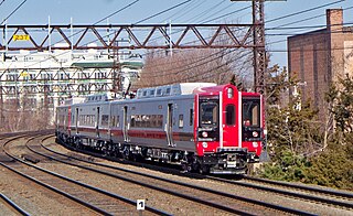
Metro-North Railroad's New Haven Line runs from New Haven, Connecticut, southwest to Mount Vernon, New York. There it joins the Harlem Line, where trains continue south to Grand Central Terminal in Manhattan. The New Haven Line's ridership, at 125,000 weekday and 39 million annual passengers, ranks as the busiest rail line in the United States. The busiest station is Stamford, with 8.4 million passengers, or 21% of the line's ridership.

Danbury Branch Commuter train line in Connecticut

The Danbury Branch is a diesel branch of the Metro-North Railroad New Haven Line from downtown Norwalk, Connecticut north to Danbury, mostly single-tracked. It opened in 1852 as the Danbury and Norwalk Railroad. Until the early 1970s the branch originally had passenger service from Danbury to Canaan, Connecticut, to Pittsfield, Massachusetts. Metro-North took over operation of the line from Conrail in 1983.

History of Norwalk, Connecticut

The history of Norwalk, Connecticut ranges from pre-contact cultures and Native Americans to the 21st century.

There are an assortment of public, private, and parochial schools in Norwalk, Connecticut.

East Norwalk Neighborhood in Fairfield, Connecticut, United States

East Norwalk is a neighborhood of Norwalk, Connecticut, located mostly in Norwalk's third taxing district with segments of its northernmost area within the first and fifth taxing districts. As one of the earliest settlements of Norwalk, it was so marked with a block of 'suitably inscribed' 'native granite' formally located on the corner of Fitch Street and East Avenue.

The Fairfield County Railroad was chartered May 1835. Its goal was to give Danbury, Connecticut, a rail link with the outside world. It became the Danbury and Norwalk Railroad by 1850 which in turn did not operate until 1852. This company preceded Danbury and Norwalk Railroad and by 1950 ceased to exist.

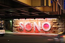
The Central or Midtown section of Norwalk, Connecticut is an urbanized area in roughly the geographic center of the city, north of the South Norwalk neighborhood and the Connecticut Turnpike. Wall Street, West Avenue and Belden Avenue are the main thoroughfares. It has also been called "Norwalk Center" or "Downtown Norwalk".

Beth Israel Synagogue (Norwalk, Connecticut) United States historic place

Built in 1906, Beth Israel Synagogue was an historic Orthodox synagogue building located at 31 Concord Street in the South Norwalk section of the city of Norwalk, Connecticut. The Moorish Revival style building is the only known synagogue building in Connecticut displaying Moorish onion domes, and is an unusual example of an urban wood-frame synagogue. Since 1972, the building has been owned and occupied by the Canaan Institutional Baptist Church.

South Main and Washington Streets Historic District United States historic place

The South Main and Washington Streets Historic District — 68-139 Washington St. and 2-24 South Main St. is a historic district in South Norwalk, Connecticut. The 110-acre (45 ha) district encompasses 35 buildings and two other structures. Varied architectural styles from the late 19th and early 20th centuries include Romanesque Revival, Second Empire, and Italianate architecture. Half of the area first became part of the National Register of Historic Places in 1977. The district was increased in 1985 with the addition of nine buildings on 2.5 acres (1.0 ha) and again in 1999, with another 10 buildings on 3 acres (1.2 ha), roughly along North Main Street from Washington Street to Ann Street.

Bridgeport, Connecticut City in Connecticut, United States

Bridgeport is a historic seaport city in the U.S. state of Connecticut. It is in Fairfield County, at the mouth of the Pequonnock River on Long Island Sound, 60 miles (97 km) from Manhattan and 40 miles (64 km) from The Bronx. It is bordered by the towns of Trumbull to the north, Fairfield to the west, and Stratford to the east.

South Norwalk Railroad Bridge

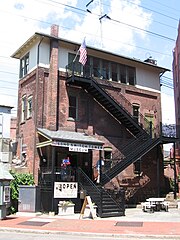
The South Norwalk Railroad Bridge is an 1895 bridge in Norwalk, Connecticut. It carries the four sets of Metro-North railroad tracks across the busy intersection of Main Street and Washington Street in the South Norwalk section of the city. The bridge is adjacent to the South Norwalk Switch Tower Museum, which showcases the railroad switch tower where tracks were physically switched at the intersection of the Danbury Branch and the New Haven Line.

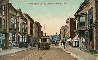
Connecticut Railway and Lighting Company was a streetcar and bus transit operator serving the region around Bridgeport, Norwalk, Derby, New Britain and Waterbury, Connecticut. It was formed in 1901 by United Gas Improvement Company of Philadelphia to manage the streetcar operations of the Connecticut Light and Power Company, which at the time included Central Railway and Electric Company, Norwalk Street Railway, and the Waterbury Traction Company. The newly formed Connecticut Railway and Lighting acquired Bridgeport Traction Company, Derby Street Railway, Milford Street Railway, Shelton Street Railway, Meriden, Southington and Compounce Tramway Company, and the Cheshire Street Railway. Connecticut Railway and Lighting was leased to the Consolidated Railway and in turn the Connecticut Company between 1906 and 1936. Streetcar operations were discontinued in 1937 when all lines were converted to bus. Transit operations continued until 1972, when all remaining bus operations were suspended and taken over by Connecticut Transit, except in Bridgeport- by the Greater Bridgeport Transit District in 1975.

The SoNo Collection is a shopping mall in the South Norwalk neighborhood of Norwalk, Connecticut. It was announced and developed by GGP Inc. in 2017, and continued by Brookfield Properties following its acquisition of GGP in 2018. The mall opened on October 11, 2019, and is the fourth mall in Fairfield County. The mall has adopted a phased opening process, including interactive art installations and community gathering spaces. It features southern Connecticut’s only Nordstrom and Bloomingdale's as the anchor stores. It is located next to Interstate 95 and Route 7.

References

  1. "SPECIAL TAXING DISTRICTS". OLR Research Report. Rute Pinho, Associate Analyst. Archived from the original on February 25, 2015. Retrieved February 9, 2017.
  2. "TAXING DISTRICTS". City of Norwalk. Government Websites by CivicPlus®. Archived from the original on February 11, 2017. Retrieved February 9, 2017.
  3. "South Norwalk, Connecticut". Acronyms.thefreedictionary.com. Retrieved August 2, 2018.
  4. https://www.seaport.org/Oyster-Festival
  5. "Archived copy". Archived from the original on January 15, 2015. Retrieved March 27, 2017.CS1 maint: archived copy as title (link)
  6. "Plan of Norwalk, Plan of South Norwalk. Fairfield County, Connecticut". Davidrumsey.com. Beers, Ellis, & Soule. 1867.
  7. "Old Well" . Retrieved August 3, 2018.
  8. 1 2 Weed, Samuel Richards; Norwalk Historical and Memorial Library Association (August 2, 2018). "Norwalk after two hundred & fifty years, an account of the celebration of the 250th anniversary of the charter of the town, 1651--September 11th--1901; including historical sketches of churches, schools, old homes, institutions, eminent men, patriotic and benevolent work, together with the record of soldiers and sailors enlisted in Norwalk from 1676 to 1898. The civic progress in the last century and statistics of commerce and other miscellany of local interest". South Norwalk, Conn., C. A. Freeman. Archived from the original on May 25, 2017. Retrieved August 2, 2018 via Internet Archive.
  9. Howard, R. H.; Crocker, Henry E. (August 2, 1879). A History of New England: Containing Historical and Descriptive Sketches of the Counties, Cities and Principal Towns of the Six New England States, Including, in Its List of Contributors, More Than Sixty Literary Men and Women, Representing Every County in New England. Crocker & Company. p.  300 . Retrieved August 2, 2018 via Internet Archive. South Norwalk Original Settlement.
  10. Conn.), South Norwalk (Norwalk), (August 2, 1898). "Charter of the City, Pub ... 1898". City Printing Company. Archived from the original on June 17, 2016. Retrieved August 2, 2018 via Google Books.CS1 maint: extra punctuation (link)
  11. Grant, Lisa Wilson. "Norwalk". Google Books. Arcadia Publishing. Archived from the original on April 28, 2016. Retrieved February 1, 2017.
  12. "The History of the Second Taxing District". Discovernorwalk.com. June 14, 2014. Archived from the original on August 4, 2017. Retrieved August 2, 2018.
  13. "Meriden Morning Record - Google News Archive Search". news.google.com. Retrieved August 2, 2018.
  14. "The Sono Collection".
  15. Lurye, Rebecca. "SoNo Collection, Norwalk's New Mall, A Retail Anomaly". courant.com. Retrieved August 2, 2018.
  16. "National Register of Historical Places - CONNECTICUT (CT), Fairfield County". Nationalregisterofhistoricplaces.com. Archived from the original on July 22, 2016. Retrieved August 2, 2018.
  17. "National Register of Historical Places - CONNECTICUT (CT), Fairfield County". Nationalregisterofhistoricplaces.com. Archived from the original on March 1, 2017. Retrieved August 2, 2018.
  18. 1 2 "National Register of Historical Places - CONNECTICUT (CT), Fairfield County". Nationalregisterofhistoricplaces.com. Archived from the original on March 1, 2017. Retrieved August 2, 2018.
  19. "Visit Us". Norwalkhistoricalsociety.org. Archived from the original on April 27, 2017. Retrieved February 11, 2017.
  20. "National Register of Historical Places - CONNECTICUT (CT), Fairfield County". Nationalregisterofhistoricplaces.com. Archived from the original on August 17, 2017. Retrieved August 2, 2018.
  21. "National Register of Historical Places - CONNECTICUT (CT), Fairfield County". Nationalregisterofhistoricplaces.com. Archived from the original on June 30, 2016. Retrieved August 2, 2018.
  22. "Police Department - Norwalk, CT - Official Website". Norwalkct.org. Archived from the original on January 8, 2017. Retrieved August 2, 2018.
  23. "Stations / Station Map - Norwalk, CT - Official Website". Norwalkct.org. Archived from the original on December 24, 2016. Retrieved August 2, 2018.