East Norwalk

Last updated

East Norwalk, Connecticut
Founders (AKA Founding) Stone Monument.jpg
Founding Monument in East Norwalk
Country Flag of the United States.svg United States
State Flag of Connecticut.svg  Connecticut
County Fairfield
City Norwalk
Time zone UTC-5:00 (Eastern)
  Summer (DST) UTC-4:00 (Eastern)
Area code(s) 475, 203

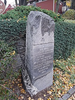
East Norwalk is a neighborhood of Norwalk, Connecticut, located mostly in Norwalk's third taxing district with segments of its northernmost area within the first and fifth taxing districts. As one of the earliest settlements of Norwalk, it was so marked with a block of 'suitably inscribed' 'native granite' [1] formally located on the corner of Fitch Street and East Avenue. [2]

Contents

History

East Norwalk is the location of Norwalk's original colonial settlements. The land was purchased from the Norwalke Indians by Roger Ludlow in 1640. Historical markers in the neighborhood include the Founding Monument [3] on East Ave and the First Settlers Monument [4] inside the East Norwalk Historical Cemetery.

British forces under General William Tryon arrived on July 10, 1779, at Fitch's Point [5] and destroyed most of Norwalk by fire; only six houses were spared. A portion, of then former Governor Thomas Fitch's house was left standing and in the 1950s it was moved to the Mill Hill Historic Park to make way for the construction of the Connecticut turnpike (I-95).

In 1913, East Norwalk combined with the Town of Norwalk, the City (formerly Borough) of Norwalk, and the city of South Norwalk into the present day City of Norwalk. East Norwalk is now within the city's third taxing district.

Neighborhood associations

East Norwalk Association: "The East Norwalk Improvement Association was founded in 1910 and "rebranded" as the East Norwalk Association in 2013. The association has been active in East Norwalk continuously for more than 100 years and founded its East Norwalk Association Library in 1915." [6]

East Norwalk Neighborhood Association (ENNA): Formerly the Eastern Norwalk Neighborhood Association which began in 2001 as 'VZSHAN', Van Zant to Sunset Hill Association of Neighbors formed to address zoning, development, traffic and other “quality of life” concerns shared by residents in neighborhoods along East Avenue on both sides of the Interstate. Today the East Norwalk Neighborhood Association area is Calf Pasture Beach north to Interstate 95 and Norwalk River and Harbor east to Westport. Residents of postal zip code 06855 are automatically members of ENNA. [7]

Surrounding neighborhoods

Norwalk's neighborhoods do not have official status, and as such are boundary deficient. Nonetheless, East Norwalk's location within the city of Norwalk can be roughly described as being south of Interstate 95, east of the Norwalk River, north of a line from the Norwalk River along 5th Street to Gregory Boulevard, west of a line along Gregory Boulevard to Emerson Street then along Stanley Street then along Strawberry Hill Avenue back to Interstate 95. [8]

Attractions, landmarks and facilities

One prominent local institution in the neighborhood is Overton's, a 60-year-old "landmark food stand" that closes down in the colder months. The owner also owns the neighboring Harbor Lights waterfront restaurant and the East Side cafe. The food stand was founded by Willis Overton in 1948 and sold to the Gavrielidis family in 2000 because the Gavrielidises were the only potential buyers who promised not to tear it down, according to Willis' son, Neil. [9]

East Norwalk Historical Cemetery

The First Settlers Monument in the East Norwalk Historical Cemetery First settlers norwalk.jpg
The First Settlers Monument in the East Norwalk Historical Cemetery

The burial location of some the first settlers of Norwalk including Governor Thomas Fitch, IV, and Thomas Fitch, V, the inspiration for the song "Yankee Doodle".

Veterans Memorial Park

"Veteran's Memorial Park and Marina" is situated on 35 acres, and includes a marina and boat launch site, a playground, bicycle and jogging paths, basketball courts, soccer, hockey, and football fields, baseball diamonds, visitor docks with full power available, a boating center and marina. The park also includes a walk esplanade overlooking scenic Norwalk Harbor." [10] It is also the site of the assembly of the annual Memorial Day parade.

The land, formally named Duffy's Field, was also once a dumpsite that was never environmentally tested. Dumping continued until the 1960s. Veterans Park was built before the state Department of Environmental Protection had a permitting process for old dumpsites.

Norwalk Oyster Festival

Located in Veterans Memorial Park.

Transportation

Public transport bus service within Norwalk is provided by Norwalk Transit District, also known as Wheels.
•Metro-North Railroad's New Haven Line runs through and stops at East Norwalk.

Emergency services

The city of Norwalk Fire Department operates 1 Fire Station in East Norwalk: Fire Station # 3 is located at 56 Van Zant St. Fire Station # 3 was the home of the Mayflower Volunteer Hook & Ladder Co. 1, one of the city's original volunteer fire companies.

Notes

  1. Scott, Angeline (1902). "Norwalk, Connecticut". The New England Magazine, Volume 32. New England Magazine Company. Retrieved February 7, 2017.
  2. "NORWALK CITY HALL AREA" . Retrieved January 7, 2017.
  3. Pelland, Dave. "FOUNDING MONUMENT, NORWALK". CT Monuments.net. Retrieved February 7, 2017.
  4. "First Settlers of Norwalk Memorial". Find a Grave. Retrieved February 7, 2017.
  5. Coughlin, Bill. "Fitch's Point". The Historical Marker Database. Retrieved February 7, 2017.
  6. "East Norwalk Association" . Retrieved January 9, 2017.
  7. "Eastern Norwalk Neighborhood Association" . Retrieved January 9, 2017.
  8. "East Norwalk neighborhood in Norwalk, Connecticut (CT), 06855 detailed profile". City Data.com. Retrieved January 4, 2017.
  9. Nickerson, John and Lucas, Jonathan, "Spring is on the menu: Overton's regulars flock to landmark food stand", news article in The Advocate of Stamford, Norwalk edition, page 1, March 15, 2007
  10. "Veteran's Memorial Park and Marina". Norwalk, CT – Official Website. CivicPlus Content Management System © 1997-2017 CivicPlus. All rights reserved. Retrieved January 10, 2017.

Coordinates: 41°06′11″N73°24′14″W / 41.103°N 73.404°W / 41.103; -73.404 (East Norwalk)

Related Research Articles

Brookfield, Connecticut Town in Connecticut, United States

Brookfield is a town in Fairfield County, Connecticut, United States, situated within the southern foothills of the Berkshire Mountains. The population was 17,528 at the 2020 census. The town is located 43 miles (69 km) northeast of New York City, making it part of the New York metropolitan area. In July 2013, Money magazine ranked Brookfield the 26th-best place to live in the United States, and the best place to live in Connecticut.

Fairfield County, Connecticut County in Connecticut, United States

Fairfield County is a county in the southwestern corner of the U.S. state of Connecticut, as well as the State’s fastest-growing from 2010 to 2020 and largest in terms of population. As of the 2010 census, the county's population was 916,829, and increased to 957,419 as of the 2020 census. The most populous county in the state, the county population represents a little over 25% of Connecticut's overall population and is one of its fastest-growing counties. The closest to the center of the New York metropolitan area, the county contains four of the state's largest cities–Bridgeport (1st), Stamford (3rd), Norwalk (6th), and Danbury (7th)–whose combined population of 433,368 is nearly half the county's total population.

Darien, Connecticut Town in Connecticut, United States

Darien is a coastal town in Fairfield County, Connecticut, United States 37 miles northeast of New York City. With a population of 21,000 and a land area of just under 13 square miles, it is the smallest town on Connecticut's "Gold Coast". It has the youngest population of any non-college town in Connecticut, a high rate of marriage, and high number of average children per household. Darien is also one of the wealthiest communities in the U.S.

Milford, Connecticut City in Connecticut, United States

Milford is a coastal city in New Haven County, Connecticut, United States, located between New Haven and Bridgeport. The population was estimated to be 53,195 in a July 2019 estimate. The city includes the village of Devon and the borough of Woodmont. Milford is part of the New York-Newark Bridgeport, NY-NJ-CT-PA Combined Statistical Area.

Stamford, Connecticut City in Connecticut, United States

Stamford is a city in the U.S. state of Connecticut. It is the second-most populous city in Fairfield County and Connecticut. With a population of 135,470, the city passed Hartford and New Haven in population as of the 2020 census,. Approximately halfway between Manhattan and New Haven at approximately 38 miles from each, Stamford is in the Bridgeport-Stamford-Norwalk-Danbury metropolitan statistical area which is a part of the New York City metropolitan area.

Norwalk, Connecticut City in Connecticut, United States

Norwalk is a city located in southwestern Connecticut, in southern Fairfield County, on the northern shore of Long Island Sound. Norwalk lies within both the New York metropolitan area and the Bridgeport metropolitan area.

South Norwalk, Connecticut Taxing District in Connecticut, United States

South Norwalk is a neighborhood and the Second Taxing District in Norwalk, Connecticut. The neighborhood was originally a settlement called 'Old Well' which became chartered as the city of 'South Norwalk' on August 18, 1870. The cities of Norwalk and South Norwalk were incorporated on June 6, 1913. The neighborhood is often referred to with the acronym 'SoNo'.

Interstate 95 (I-95) is the main north–south Interstate Highway on the East Coast of the United States, running in a general east–west compass direction for 111.57 miles (179.55 km) in Connecticut, from the New York state line to the Rhode Island state line. I-95 from Greenwich to East Lyme is part of the Connecticut Turnpike, during which it passes through the major cities of Stamford, Bridgeport, and New Haven. After leaving the turnpike in East Lyme, I-95 is known as the Jewish War Veterans Memorial Highway and passes through New London, Groton, and Mystic, before exiting the state through North Stonington at the Rhode Island border.

Overton Park United States historic place

Overton Park is a large, 342-acre (138 ha) public park in Midtown Memphis, Tennessee. The park grounds contain the Memphis Brooks Museum of Art, Memphis Zoo, a 9-hole golf course, the Memphis College of Art, Rainbow Lake, Veterans Plaza, the Greensward, and other features. The Old Forest Arboretum of Overton Park, one of the few remaining old growth forests in Tennessee, is a natural arboretum with labeled trees along trails.

East Norwalk station

East Norwalk station is a commuter rail station on the Metro-North Railroad New Haven Line, located in the East Norwalk neighborhood of Norwalk, Connecticut. The station building was constructed by Metro-North in the 1980s.

History of Norwalk, Connecticut

The history of Norwalk, Connecticut ranges from pre-contact cultures and Native Americans to the 21st century.

The Central or Midtown section of Norwalk, Connecticut is an urbanized area in roughly the geographic center of the city, north of the South Norwalk neighborhood and the Connecticut Turnpike. Wall Street, West Avenue and Belden Avenue are the main thoroughfares. It has also been called "Norwalk Center" or "Downtown Norwalk".

Pearl Harbor Memorial Bridge (Connecticut)

The Pearl Harbor Memorial Bridge, commonly referred to as the Q Bridge by locals, is an extradosed bridge that carries Interstate 95 over the mouth of the Quinnipiac River in New Haven, in the U.S. state of Connecticut. This bridge replaced the original 1,300 m (0.8 mi) span which opened on January 2, 1958. The old bridge had a girder and floorbeam design where steel beams supported a concrete bridge deck that carried three lanes of traffic in each direction with no inside or outside shoulders. The bridge was officially dedicated as the Pearl Harbor Memorial Bridge in 1995 to commemorate the attack on Pearl Harbor.

Spring Hill (Norwalk) Neighborhood in Fairfield, Connecticut, United States

Spring Hill is a section of Norwalk, Connecticut named after the hill on which most of the neighborhood sits. The neighborhood is located west of the Central section of Norwalk, across U.S. Route 7 and north of Interstate 95 and U.S. Route 1. Norwalk Hospital is on the eastern edge of the neighborhood. Riverside Cemetery is on the northeastern edge.

Calf Pasture Beach

Calf Pasture Beach is an historically significant park and beach in Norwalk, Connecticut.

Mill Hill Historic Park

Mill Hill Historic Park in Norwalk, Connecticut is a living history museum composed of three buildings: the circa 1740 Governor Thomas Fitch IV "law office", the circa 1826 Downtown District Schoolhouse, and the 1835 Norwalk Town Hall; as well as a historic cemetery also called the Town House Hill Cemetery. The museum is also known as the Mill Hill Historical Complex in some references and the sign at the parking lot reads Norwalk Mill Hill Museum.

Norwalk Harbor is a recreational and commercial harbor and seaport at the estuary of the Norwalk River where it flows into Long Island Sound in Norwalk, Connecticut, United States.

Rogers Park is a 56-acre public park and recreational facility in Danbury, Connecticut, United States, located at the end of Main Street at South Street. It hosts six baseball fields, four softball fields, a multi-purpose turf field, eight tennis courts, seven volleyball courts, four handball-paddleball courts, a spray park, a playground, an outdoor ice rink, a concession stand, a pond with a hiking/nature trail, the War Memorial building, several veterans monuments and the Charles Ives House.

Bridgeport, Connecticut City in Connecticut, United States

Bridgeport is a historic seaport city in the U.S. state of Connecticut, and its largest city. With a population of 148,654 in 2020, it is also the fifth-most populous in New England. Located in Fairfield County at the mouth of the Pequonnock River on Long Island Sound, it is 60 miles (97 km) from Manhattan and 40 miles (64 km) from The Bronx. It is bordered by the towns of Trumbull to the north, Fairfield to the west, and Stratford to the east. Bridgeport and other settlements in Fairfield County make up the Bridgeport-Stamford-Norwalk-Danbury metropolitan statistical area, the second largest metropolitan area in Connecticut. The Bridgeport-Stamford-Norwalk-Danbury metropolis forms part of the New York megacity.

East Norwalk Historical Cemetery

Established in c. 1655, the East Norwalk Historical Cemetery is Norwalk's oldest cemetery, and many of the area's first settlers are buried there. The cemetery is owned and maintained by the Third Taxing District, formally known as the East Norwalk Fire District of the Town of Norwalk, and before that it was known as the Down Town School District. Triangle shaped and surrounded clockwise by Gregory Boulevard, Cemetery Street and East Avenue it is situated in the neighborhood of East Norwalk.