
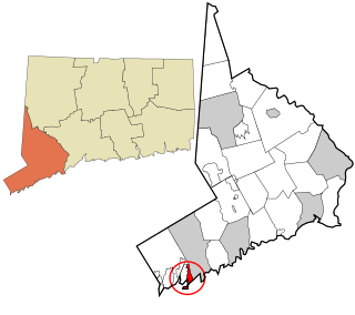
Fairfield County is a county in the southwestern corner of the U.S. state of Connecticut. It is the most populous county in the state and was also its fastest-growing from 2010 to 2020. As of the 2020 census, the county's population was 957,419, representing 26.6% of Connecticut's overall population. The closest to the center of the New York metropolitan area, the county contains four of the state's seven largest cities—Bridgeport (first), Stamford (second), Norwalk (sixth) and Danbury (seventh)—whose combined population of 433,368 is nearly half the county's total population.

Greenwich is a town in southwestern Fairfield County, Connecticut, United States. As of the 2020 census, it had a population of 63,518. It is the largest town on Connecticut's affluent Gold Coast. Greenwich is home to many hedge funds and financial services firms due to its residential setting and proximity to Manhattan.
Mianus, formerly Mayamus and Upper Landing, is a neighborhood in the town of Greenwich in the U.S. state of Connecticut. Unlike other Greenwich neighborhoods such as Cos Cob or Old Greenwich, Mianus does not have its own ZIP code or post office. Mianus lies partly in the Cos Cob ZIP code, partly in the Riverside ZIP code area, and partly in the Old Greenwich ZIP code area. It lies at an elevation of 23 feet and is home to an elementary school. Mianus was also home to the Mianus Motor Works, a marine-engine manufacturer.

Cos Cob is a neighborhood and census-designated place in the town of Greenwich, Connecticut, United States. It is located on the Connecticut shoreline in southern Fairfield County. It had a population of 6,873 at the 2020 census.

Byram is a neighborhood/section and census-designated place (CDP) in the town of Greenwich in Fairfield County, Connecticut, United States. It had a population of 4,146 at the 2010 census, and a census-estimated population of 4,216 in 2018. An endcap of Connecticut's Gold Coast, Byram is the southernmost point in the town of Greenwich and the U.S. state of Connecticut. It is separated from Port Chester, Westchester County, New York, by the Byram River. Byram was once known as East Port Chester.

The history of Greenwich, Connecticut, United States.

Green's Farms is the oldest neighborhood in the town of Westport in Fairfield County, Connecticut, United States. It was first listed as a census-designated place at the 2020 census.

Greenwich Public Schools is a school district located in Fairfield County, in Greenwich, Connecticut, United States. The district has boundaries that are coterminous with those of the town. Approximately 8,840 students in grades K–12 attend the Greenwich Public Schools.

Riverside is a neighborhood/section in the town of Greenwich in Fairfield County, Connecticut, United States. As of the 2020 census, it had a population of 8,843.
Old Greenwich is a coastal village in Fairfield County, Connecticut, United States. As of the 2010 census it had a population of 6,611.

Glenville Historic District, also known as Sherwood's Bridge, is a 33.9 acres (13.7 ha) historic district in the Glenville neighborhood of the town of Greenwich, Connecticut. It is the "most comprehensive example of a New England mill village within the Town of Greenwich". It "is also historically significant as one of the town's major staging areas of immigrants, predominantly Irish in the 19th century and Polish in the 20th century" and remains "the primary settlement of Poles in the town". Further, "[t]he district is architecturally significant because it contains two elaborate examples of mill construction, designed in the Romanesque Revival and a transitional Stick-style/Queen Anne; an excellent example of a Georgian Revival school; and notable examples of domestic and commercial architecture, including a Queen Anne mansion and an Italianate store building."
Compo is a census-designated place (CDP) in the town of Westport, Fairfield County, Connecticut, United States. It is in the south-central part of the town, lying between the Saugatuck River and the neighborhood of Saugatuck to the west, and Compo Cove, Sherwood Millpond, and the neighborhood of Greens Farms to the east. The CDP extends south to Compo Beach on Long Island Sound and north to U.S. Route 1. Interstate 95 crosses the middle of the CDP from east to west, with access from either Saugatuck or Greens Farms.

Wilton Center is a neighborhood/section and census-designated place (CDP) in the town of Wilton in Fairfield County, Connecticut, United States. As of the 2010 census it had a population of 732. The CDP partially overlaps the Wilton Center Historic District.

The Glenville School is a historic school building at 449 Pemberwick Road in the Glenville section of Greenwich, Connecticut, United States. It was listed on the National Register of Historic Places in 2003. It was one of several schools built in the town in the 1920s, when it consolidated its former rural school districts into a modern school system, with modern buildings.
The New Mill and Depot Building of the former Hawthorne Woolen Mill are located in Greenwich, Connecticut, United States. The two structures were built on an existing textile mill complex in the 1870s.

Pemberwick is a neighborhood/section and census-designated place in Greenwich in Fairfield County, Connecticut, United States. As of the 2010 census it had a population of 3,680.

Greenwich is a census-designated place (CDP) in Fairfield County, Connecticut, United States. It is one of several CDPs within the town of Greenwich and corresponds to the historic municipal center of the town and surrounding residential and commercial areas. As of the 2010 census, the population of the Greenwich CDP was 12,942, out of 61,171 in the entire town.

The Gold Coast, also known as Lower Fairfield County or Southwestern Connecticut, is an affluent part of Western Connecticut that includes the entire southern portion of Fairfield County as defined by the U.S. Census Bureau, Super-Public Use Microdata Area (Super-PUMA) Region 09600. The area is about 50 miles (80 km) northeast of New York City, and is home to many wealthy Manhattan business executives. Parts of the region are served by the Western Connecticut Council of Governments.
Rock Ridge is a census-designated place (CDP) in the town of Greenwich, Fairfield County, Connecticut, United States. It is in the western part of the town, just 1 mile (2 km) east of the New York state border. Rock Ridge was first listed as a CDP prior to the 2020 census.
Indian Field is a census-designated place (CDP) in the town of Greenwich, Fairfield County, Connecticut, United States. It is in the southern part of the town, on a peninsula between Indian Harbor to the west and Cos Cob Harbor to the east. It extends south into Captain Harbor, an inlet of Long Island Sound, and it extends north as far as U.S. Route 1. Interstate 95 crosses the CDP, with access from Exit 4.

