
Brookfield is a town in Fairfield County, Connecticut, United States, situated within the southern foothills of the Berkshire Mountains. The population was 17,528 at the 2020 census. The town is located 55 miles (89 km) northeast of New York City, making it part of the New York-Newark, NY-NJ-CT-PA combined statistical area. The town is part of the Western Connecticut Planning Region. In July 2013, Money magazine ranked Brookfield the 26th-best place to live in the United States, and the best place to live in Connecticut.

Fairfield County is a county in the southwestern corner of the U.S. state of Connecticut. It is the most populous county in the state and was also its fastest-growing from 2010 to 2020. As of the 2020 census, the county's population was 957,419, representing 26.6% of Connecticut's overall population. The closest to the center of the New York metropolitan area, the county contains four of the state's seven largest cities—Bridgeport (first), Stamford (second), Norwalk (sixth) and Danbury (seventh)—whose combined population of 433,368 is nearly half the county's total population.
Monroe is a town located in eastern Fairfield County, Connecticut, United States. The population was 18,825 at the 2020 census. The town is part of the Greater Bridgeport Planning Region.

Hamden is a town in New Haven County, Connecticut, United States. The town's nickname is "The Land of the Sleeping Giant". The town is part of the South Central Connecticut Planning Region. The population was 61,169 at the 2020 census.

Lebanon is a town in New London County, Connecticut, United States. The town is part of the Southeastern Connecticut Planning Region. The population was 7,142 at the 2020 census. The town lies just to the northwest of Norwich, directly south of Willimantic, 20 miles (32 km) north of New London, and 20 miles (32 km) east of Hartford. It is best known for its role in the American Revolution, when it was a major base of American operations, and for its historic town green, which is one of the largest in the nation and the only one still used partially for agriculture.
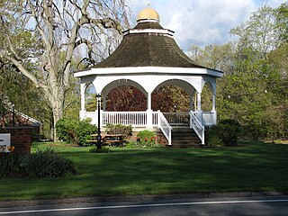
Pomfret is a town located in Windham County, Connecticut, United States, with a population of 4,266 according to the 2020 United States Census. The town is part of the Northeastern Connecticut Planning Region. The town was incorporated in 1713 and was named after Pontefract in West Yorkshire, England. The land on which Pomfret stands today was purchased from Native Americans in 1686 in a deal known as the "Mashmuket Purchase" or "Mashamoquet Purchase".

Shelton is a city in Fairfield County, Connecticut, United States. The population was 40,869 at the 2020 United States Census. The city is part of the Naugatuck Valley Planning Region.

Trumbull is a town located in Fairfield County, Connecticut, United States. The town is part of the Greater Bridgeport Planning Region, and borders on the cities of Bridgeport and Shelton, as well as the towns of Stratford, Fairfield, Easton and Monroe. The population was 36,827 during the 2020 census. The Trumbull area was the home of the Golden Hill Paugussett Indian Nation for thousands of years before the English settlement was made in 1639.

New Milford is a town in Litchfield County, Connecticut, United States. The town, part of Greater Danbury, as well as the New York Metropolitan Area, has a population of 28,115 as of the 2020 census. New Milford lies 14 miles (23 km) north of Danbury on the banks of the Housatonic River, and shares its border with the northeastern shore of Candlewood Lake. It is the largest town in the state of Connecticut in terms of land area at nearly 63.7 mi2 (164.9822 km2). The town center is listed as a census-designated place (CDP).

Gaylordsville is a village (neighborhood/borough) in the northwest corner of the town of New Milford, Litchfield County, Connecticut, United States. It was listed as a census-designated place (CDP) prior to the 2020 census.
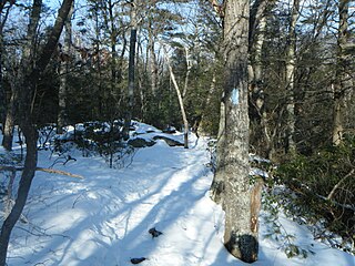
The Shenipsit Trail is a Blue-Blazed hiking trail located in Central Connecticut between 3.5 and 7 miles (11 km) east of the Connecticut River. It runs 50 miles (80 km) in a north-south direction. The southern trailhead is on Gadpouch Road in Cobalt, CT on the southern end of the Meshomasic State Forest. The northern trailhead is on Greaves Road past Bald Mountain and the Shenipsit State Forest in Stafford, CT. The trail runs primarily through the Shenipsit and Meshomasic State Forests, and Case Mountain, but also utilizes other public and private land holdings. The Native American name Shenipsit means at the great pool, referring to the Shenipsit Lake, which the trail passes by. The Shenipsit Trail is divided into three sections: South, Central, and North. The Shenipsit Trail is one of the blue-blazed hiking trails managed by the Connecticut Forest and Park Association (CFPA).

Route 127 is a state highway in southwestern Connecticut, running entirely from Bridgeport to Trumbull. It serves as a minor arterial, connecting all four major freeways in the Bridgeport area.

Trumbull, a town in Fairfield County, Connecticut, in the New England region of the United States, was originally home to the Golden Hill Paugussett Indian Nation, and was colonized by the English during the Great Migration of the 1630s as a part of the coastal settlement of Stratford.
Bridgeport is the most populous city in the U.S. state of Connecticut and the fifth-most populous city in New England, with a population of 148,654 in 2020. Located in eastern Fairfield County at the mouth of the Pequonnock River on Long Island Sound, it is a port city 60 miles (97 km) from Manhattan and 40 miles (64 km) from The Bronx. It borders the towns of Trumbull to the north, Fairfield to the west, and Stratford to the east. Bridgeport and other towns in Fairfield County make up the Greater Bridgeport Planning Region, as well as the Bridgeport–Stamford–Norwalk–Danbury metropolitan statistical area, the second largest metropolitan area in Connecticut. The Bridgeport–Stamford–Norwalk–Danbury metropolis forms part of the New York metropolitan area.

The Pequonnock River is a 16.7-mile-long (26.9 km) waterway in eastern Fairfield County, Connecticut. Its watershed is located in five communities, with the majority of it located within Monroe, Trumbull, and Bridgeport. The river has a penchant for flooding, particularly in spring since the removal of a retention dam in Trumbull in the 1950s. There seems to be a sharp difference of opinion among historians as to just what the Indian word Pequonnock signifies. Some insist it meant cleared field or open ground; others are sure it meant broken ground; while a third group is certain it meant place of slaughter or place of destruction.
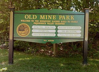
The Old Mine Park Archaeological Site is a historic site in the Long Hill section of Trumbull, Connecticut, United States. It was mined from 1828 to 1920 and during 1942-1946, and has been incorporated in a municipal park. It was added to the National Register of Historic Places in 1990.

The Tunxis Trail is a 79-mile (127 km) Blue-Blazed hiking trail "system" that traverses the western ridge of the central Connecticut Valley. The mainline trail is not completely contiguous, notably there are two gaps of several miles.

The Paugussett Trail is a 14-mile (23 km) Blue-Blazed hiking trail "system" in the lower Housatonic River valley in Fairfield County and, today, is entirely in Shelton and Monroe, Connecticut. Much of the trail is in Indian Well State Park and the Town of Monroe's Webb Mountain Park. The mainline trail is primarily southeast to northwest with three short side or spur trails.
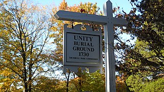
The Unity Burial Ground is a small graveyard located on the southeast end of White Plain in the Nichols section of Trumbull, Connecticut. It is located a few rods north of the site of the first meeting house that was built in the parish of Unity, off of White Plains Road. The cemetery was laid out in 1730 and the first burial was that of 7 year old Samuel Bennitt on June 21, 1731. There are over 110 gravestones, 90 unmarked field stones and 241 known grave sites, and most of the original stones face east. This is unusual, as it runs contrary to the common practice of placing stones so that they face the road. The latest known burial was for Charles E Booth Jr. on August 17, 1935.

Long Hill is a neighborhood and census-designated place (CDP) in the town of Trumbull in Fairfield County, Connecticut, United States. It is located west of the Pequonnock River. The main thoroughfare is Connecticut Route 111, present-day Main Street. It was listed as a census-designated place prior to the 2020 census.


