Candlewood Orchards, Connecticut | |
|---|---|
 Sign at Main Entrance | |
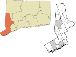 Location within the Western Connecticut Planning Region and the state of Connecticut | |
 Candlewood Orchards  Candlewood Orchards | |
| Coordinates: 41°28′30″N73°26′24″W / 41.47500°N 73.44000°W | |
| Country | |
| State | |
| Counties | Fairfield |
| Region | Western CT |
| Town | Brookfield |
| Area | |
• Total | 0.29 sq mi (0.75 km2) |
| • Land | 0.29 sq mi (0.75 km2) |
| • Water | 0 sq mi (0.0 km2) |
| Elevation | 450 ft (140 m) |
| Time zone | UTC-5 (Eastern (EST)) |
| • Summer (DST) | UTC-4 (EDT) |
| ZIP Code | 06804 (Brookfield) |
| Area codes | 203/475 |
| FIPS code | 09-11640 |
| GNIS feature ID | 2805938 [2] |
Candlewood Orchards is a private residential community and census-designated place (CDP) in the town of Brookfield, Fairfield County, Connecticut, United States. It is in the northwestern part of the town, on the eastern shore of Candlewood Lake. It is bordered to the north by Candlewood Shores and to the west and south by the town of New Fairfield.
Candlewood Orchards was first listed as a CDP prior to the 2020 census.
