
Southcote is a hamlet in the parish of Linslade, in Bedfordshire, England. It is in the civil parish of Leighton-Linslade. The hamlet name is Anglo Saxon in origin and means 'southern cottage'.
Warbstow is a village and civil parish in Cornwall, England, United Kingdom. The parish has a population of 439 according to the 2001 census, increasing to 520 at the 2011 census.
Jacobstow is a civil parish and village in north Cornwall, England, United Kingdom. The village is located east of the A39 road approximately seven miles (11 km) south of Bude.

St Veep is a civil parish in Cornwall, England, United Kingdom, situated above the east bank of the River Fowey about three miles (5 km) south-east of Lostwithiel. It is bordered by the parishes of St Winnow to the north-west, Boconnoc to the north, Lanreath to the east Polperro to the south-east and Lanteglos to the south. The River Fowey forms its western boundary. The parish is named after Saint Veep of whom little is known.
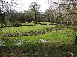
Penhallam is the site of a fortified manor house near Jacobstow in Cornwall, England. There was probably an earlier, 11th-century ringwork castle on the site, constructed by Tryold or his son, Richard fitz Turold in the years after the Norman invasion of 1066. Their descendants, in particular Andrew de Cardinham, created a substantial, sophisticated manor house at Penhallam between the 1180s and 1234, building a quadrangle of ranges facing onto an internal courtyard, surrounded by a moat and external buildings. The Cardinhams may have used the manor house for hunting expeditions in their nearby deer park. By the 14th century, the Cardinham male line had died out and the house was occupied by tenants. The surrounding manor was broken up and the house itself fell into decay and robbed for its stone. Archaeological investigations between 1968 and 1973 uncovered its foundations, unaltered since the medieval period, and the site is now managed by English Heritage and open to visitors.

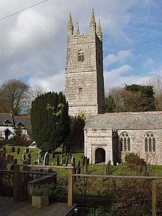
Poundstock is a civil parish and a hamlet on the north coast of Cornwall, England, United Kingdom. The hamlet is situated four miles (6.5 km) south of Bude half-a-mile west of the A39 trunk road about one mile from the coast.
Kents is a hamlet in the parish of Jacobstow, Cornwall, England.

Pencuke is a hamlet near Higher Crackington in northeast Cornwall, England, UK.

Porthmeor is a hamlet that consists of two farms, Higher and Lower Porthmeor, in the parish of Zennor in Cornwall, England. It should not be confused with Porthmeor beach at St Ives. Higher Porthmeor lies along the B3306 road which connects St Ives to the A30 road and Lower Porthmeor is nearer the coast.
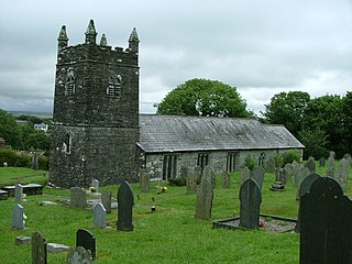
St James’ Church, Jacobstow is a Grade I listed parish church in the Church of England in Jacobstow, Cornwall.

Southcott is a surname of an ancient and prominent family from the English counties of Devon and Cornwall.

On 25 December 2013, Christmas Day, a landslide occurred in the village of Calstock in the county of Cornwall, United Kingdom. The landslide, which hit late in the morning, was believed to have been caused by a burst of heavy rainfall and numerous village wells surrounding the landslide. The landslide collapsed the road of Lower Kelly, which was a vital and only road connection to the town of Calstock, trapping forty cars.

Poundstock is an electoral division of Cornwall in the United Kingdom and returns one member to sit on Cornwall Council. The current Councillor is Nicky Chopak, a Liberal Democrat.

Carharrack, Gwennap and St Day was an electoral division of Cornwall in the United Kingdom which returned one member to sit on Cornwall Council between 2013 and 2021. It was abolished at the 2021 local elections, being succeeded by Redruth Central, Carharrack and St Day and Lanner, Stithians and Gwennap.

Southcott is a hamlet east of Bideford in the parish of Westleigh in the district of North Devon, in the county of Devon, England.

