
The Tamar is a river in south west England that forms most of the border between Devon and Cornwall. A part of the Tamar Valley is a World Heritage Site due to its historic mining activities.
Botolph Claydon is a hamlet in the civil parish of East Claydon, in Buckinghamshire, England. It is situated about 9 miles (14 km) east of Bicester in Oxfordshire, and 7 miles (11 km) north west of Aylesbury.

East Devon is a local government district in Devon, England. Its council is based in the town of Honiton, although Exmouth is the largest town. The district also contains the towns of Axminster, Budleigh Salterton, Cranbrook, Ottery St Mary, Seaton and Sidmouth, along with numerous villages and surrounding rural areas.

Bargeddie is a village in North Lanarkshire, Scotland, just inside the suburban fringe of Glasgow, 8 miles (13 km) east of the city centre, and close to the junction of the M73 and M8 motorways. The nearest major town is Coatbridge, 2 miles (3 km) to the east.

Bransbury is a hamlet in Hampshire, England, part of the parish of Barton Stacey. The nearest village is Barton Stacey, halfway between Winchester and Andover; there is a junction for Bransbury on the A303 towards Exeter. Bransbury has twenty-two dwellings: a collection of agricultural workers’ cottages with gardens of generous proportions, Bransbury Manor, which dates from the 18th century, and Bransbury Mill, a Grade II listed building. The Crook and Shears Inn public house was converted into a dwelling in the late 20th century. The hamlet straddles the River Dever.

Bovey Tracey is a town and civil parish in Devon, England, on the edge of Dartmoor, its proximity to which gives rise to the slogan used on the town's boundary signs, "The Gateway to the Moor". It is often known locally as "Bovey". It is about 10 miles south-west of Exeter and lies on the A382 road, about halfway between Newton Abbot and Moretonhampstead. The village is at the centre of the electoral ward of Bovey. At the 2011 census the population of this ward was 7,721.
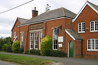
All Saints is a civil parish in East Devon, Devon, England. It has a population of 498 according to the 2001 census. The parish includes the hamlets of All Saints, Smallridge, Churchill, Alston and Waggs Plot. This area also has one cricket pitch, a primary school, pre-school and a church.

Alverdiscott is a village, civil parish, former manor and former ecclesiastical parish in the Torridge district of Devon, England, centred 5.5 miles (9 km) south-south-west of Barnstaple.

Buckland-Tout-Saints is a village and civil parish in the South Hams district of Devon, England. In the 2001 census it had a population of 178, up from a population of only 37 in 1901. The parish also includes the hamlets of Bearscombe, Goveton and Ledstone. The parish is surrounded clockwise from the north by the parishes of Woodleigh, East Allington, Frogmore and Sherford, Kingsbridge, Churchstow, and a short boundary with Loddiswell.

Perranzabuloe is a coastal civil parish and a hamlet in Cornwall, England, United Kingdom. Perranzabuloe parish is bordered to the west by the Atlantic coast and St Agnes parish, to the north by Cubert parish, to the east by St Newlyn East and St Allen parishes and to the south by Kenwyn parish. The hamlet is situated just over a mile (2 km) south of the principal settlement of the parish, Perranporth; the hamlet is also seven miles (11 km) south-southwest of Newquay. Other settlements in the parish include Perrancoombe, Goonhavern, Mount and Callestick. The parish population was 5,382 in the 2001 census, increasing to 5,486 at the 2011 census.
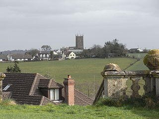
St Giles in the Wood is a village and civil parish in the Torridge district of Devon, England. The village lies about 2.5 miles east of the town of Great Torrington, and the parish, which had a population of 566 in 2001 compared with 623 in 1901, is surrounded clockwise from the north by the parishes of Huntshaw, Yarnscombe, High Bickington, Roborough, Beaford, Little Torrington and Great Torrington. Most of the Victorian terraced cottages in the village, on the east side of the church, were built by the Rolle Estate.

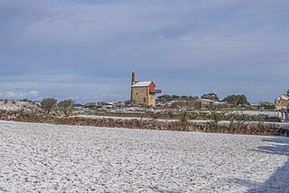
Meldon is a hamlet in West Devon, on the edge of Dartmoor in Devon, England. It is 4 km south-west of Okehampton. Its main features are the Meldon Quarry and Meldon Reservoir and the nearby Meldon Viaduct.

Okehampton Hamlets is a civil parish in the Borough of West Devon and the English county of Devon, it runs independently from the Okehampton Town Council, meetings are held at the Meldon Village Hall.

Westleigh is a village and civil parish in the North Devon district, in the English County of Devon.
Carnebone is a small hamlet and farm in the parish of Wendron in Cornwall, England. It lies to the east of Wendron, to the northeast of Trevenen, just to the west of Seworgan, along the A394 road, 3.8 miles (6.1 km) northeast of Helston.
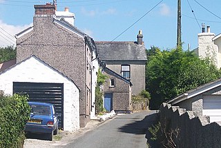
Norris Green is a village in Cornwall, England, UK. It was enlarged from a farming hamlet so that it now adjoins the neighbouring village of Higher Metherell. Both settlements are within the civil parish of Calstock which borders the River Tamar, the county boundary with Devon in south-east Cornwall.

Southcott is a hamlet in the civil parish of Okehampton Hamlets, in West Devon, England. The hamlet name is Anglo Saxon in origin and means 'southern cottage'.

Southcott is a hamlet west of Great Torrington in the parish of Frithelstock in the district of Torridge, Devon, England.
Southcott, formerly also Southcote, is a hamlet north of Dartmoor in the parish of Winkleigh in the district of Torridge, Devon, England.

