Newington may refer to several places:

The London Borough of Southwark in South London forms part of Inner London and is connected by bridges across the River Thames to the City of London and London Borough of Tower Hamlets. It was created in 1965 when three smaller council areas amalgamated under the London Government Act 1963. All districts of the area are within the London postal district. It is governed by Southwark London Borough Council.

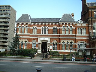
Newington is a district of South London, just south of the River Thames, and part of the London Borough of Southwark. It was an ancient parish and the site of the early administration of the county of Surrey. It was the location of the County of London Sessions House from 1917, in a building now occupied by the Inner London Crown Court.

Lambeth is a London borough in South London, England, which forms part of Inner London. Its name was recorded in 1062 as Lambehitha and in 1255 as Lambeth. The geographical centre of London is at Frazier Street near Lambeth North tube station, though nearby Charing Cross on the other side of the Thames in the City of Westminster is traditionally considered the centre of London.

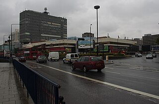
Elephant and Castle is an area of South London, England, in the London Borough of Southwark. The name also informally refers to much of Walworth and Newington, due to the proximity of the London Underground station of the same name. The name is derived from a local coaching inn.

New Kent Road is a 1 kilometre (0.6 mi) road in the London Borough of Southwark. The road was created in 1751 when the Turnpike Trust upgraded a local footpath. This was done as part of the general road improvements associated with the creation of Westminster Bridge; in effect it was possible to travel from the West End/ Westminster to the south-east without having to go via the Borough of Southwark but could now cross St George's Fields to the junction of Newington Causeway and Newington Butts which is where New Kent Road starts at Elephant & Castle. The route runs eastward for a few hundred yards to the junction of Great Dover Street and Tower Bridge Road, known as Bricklayers Arms, where it joins the original route to the south-east Old Kent Road.
The Metropolitan Borough of Southwark was a metropolitan borough in the County of London from 1900 to 1965. It was created to cover the western section of the ancient borough of Southwark and the parish of Newington. In common with the rest of inner London, the borough experienced a steady decline in population throughout its existence. The borough council made an unsuccessful attempt to gain city status in 1955. Its former area is now the northwestern part of the current London Borough of Southwark.

Camberwell was a civil parish and metropolitan borough in south London, England. Camberwell was an ancient parish in the county of Surrey, governed by an administrative vestry from 1674. The parish was included in the area of responsibility of the Metropolitan Board of Works in 1855 and became part of the County of London in 1889. The parish of Camberwell became a metropolitan borough in 1900, following the London Government Act 1899, with the parish vestry replaced by a borough council. In 1965 the borough was abolished and its former area became part of the London Borough of Southwark in Greater London.

Lambeth was a civil parish and metropolitan borough in south London, England. It was an ancient parish in the county of Surrey. The parish was included in the area of responsibility of the Metropolitan Board of Works in 1855 and became part of the County of London in 1889. The parish of Lambeth became a metropolitan borough in 1900, following the London Government Act 1899, with the parish vestry replaced by a borough council.

The region of Greater London, including the City of London, is divided into 73 parliamentary constituencies which are sub-classified as borough constituencies, affecting the type of electoral officer and level of expenses permitted.
Newington Causeway is a road in Southwark, London, between the Elephant and Castle and Borough High Street. Elephant & Castle Underground station is at the southern end. It follows the route of the old Roman road Stane Street.

Bermondsey and Old Southwark is a constituency in the House of Commons of the UK Parliament. Since 2015, it has been represented by Neil Coyle, who was elected as a Labour MP but was suspended from the party from 2022 to 2023 following an accusation of racism.
Newington Butts is a former hamlet, now an area of the London Borough of Southwark, London, England, that gives its name to a segment of the A3 road running south-west from the Elephant and Castle junction. The road continues as Kennington Park Road leading to Kennington; a fork right is Kennington Lane, leading to Vauxhall Bridge. Michael Faraday was born in Newington Butts.

Hackney North was a parliamentary constituency in "The Metropolis". It returned one Member of Parliament (MP) to the House of Commons of the Parliament of the United Kingdom.

Peckham was a borough constituency in South London which returned one Member of Parliament (MP) to the House of Commons of the Parliament of the United Kingdom. Elections were held using the first-past-the-post voting system.
Hackney South was a parliamentary constituency in "The Metropolis". It was represented by nine Members of Parliament to the House of Commons of the Parliament of the United Kingdom, only two of whom, Horatio Bottomley and Herbert Morrison, were elected more than once.
Battersea South was a parliamentary constituency, originally in the County of London and later in Greater London. It returned one Member of Parliament (MP) to the House of Commons of the UK Parliament.
Lambeth was a constituency 1832—1885 loosely equivalent in area to the later administrative units: the London Borough of Lambeth and the south-west and centre of the London Borough of Southwark. It returned two members of parliament (MPs) to the House of Commons of the UK Parliament by the bloc vote version of the first-past-the-post system.

Lambeth North was a borough constituency centred on the Lambeth district of South London. It returned one Member of Parliament (MP) to the House of Commons of the Parliament of the United Kingdom, elected by the first past the post system.

Southwark St George the Martyr was a civil parish in the metropolitan area of London, England and part of the ancient Borough of Southwark. In 1855 the parish vestry became a local authority within the area of responsibility of the Metropolitan Board of Works. It became part of the Metropolitan Borough of Southwark in 1900 and was abolished as a civil parish in 1930.

