
Methuen is a 23-square-mile city in Essex County, Massachusetts, United States. The population was 53,059 at the 2020 census. Methuen lies along the northwestern edge of Essex County, just east of Middlesex County and just south of Rockingham County, New Hampshire. The city is bordered by Haverhill to the northeast, North Andover to the southeast, Lawrence and Andover to the south, Dracut to the west, Pelham, New Hampshire to the northwest, and Salem, New Hampshire to the north. Methuen is located 17 miles (27 km) southwest from Newburyport, 30 miles (48 km) north-northwest of Boston and 25 miles (40 km) south-southeast of Manchester, New Hampshire.

The Mechanic Street Historic District encompasses a historic 19th-century mill and mill village in a 14-block area of the Pawcatuck section of Stonington, Connecticut. Extending along the Pawcatuck River and south of West Broad Street, the area includes a large brick mill complex on the banks of the river, and a neighborhood of well-preserved worker housing on the road grid to its west. The district was listed on the National Register of Historic Places in 1988.

The Dorchester-Milton Lower Mills Industrial District is a historic district on both sides of the Neponset River in the Dorchester area of Boston and in the town of Milton, Massachusetts. It encompasses an industrial factory complex, most of which was historically associated with the Walter Baker & Company, the first major maker of chocolate products in the United States. The industrial buildings of the district were built between about 1868 and 1947. They were listed as part of the district on the National Register of Historic Places in 1980, with a slight enlargement in 2001. The buildings have been adapted for mixed industrial/retail/residential use.
The Baldwinville Village Historic District encompasses the historic elements of the village of Baldwinville, a 19th-century mill village in northern Templeton, Massachusetts. Although its industrial elements have largely been lost, the district retains period housing and civic buildings. It was listed on the National Register of Historic Places in 1986.

David Nevins Jr. was a wealthy Yankee merchant in the city of Methuen, Massachusetts during the industrial boom of the late 19th century.

Mill River Historic District is a historic district encompassing the traditional center of government and a former industrial mill village along the Konkapot River in the village of Mill River in New Marlborough, Massachusetts. The district is roughly bounded by Main Street and River Church, Southfield, Clayton, School, and Hayes Hill Roads. It encompasses about 425 acres (172 ha), and contains mostly 19th century residential and civic buildings, as well as remnants of 19th century industrial activity.

The South Lee Historic District encompasses the historic portion of the village of South Lee in Lee, Massachusetts. Extending mainly along Massachusetts Route 102 between Fairview Street and the Stockbridge town line, the village is a well-preserved 19th-century mill village, with fine Federal and Greek Revival buildings and a later 19th-century paper mill. It was listed on the National Register of Historic Places in 1999.

The Cushman Village Historic District is a historic district encompassing a portion of the Cushman Village area of Amherst, Massachusetts, which was a significant mill village during the 19th century. It is centered on the triangle formed by Bridge, Henry, and Pine Streets in northeastern Amherst, and arose because of the presence of falls on the Mill River, whose water power was harnessed for mills as early as the mid-18th century. Two houses survive from the colonial period. The village, although it was defined for many years by the mills, no longer has any industrial buildings, as they were demolished or destroyed by fire. Most of the houses in the district were built before 1860, the peak of the village's industrial activity. The district was listed on the National Register of Historic Places in 1992.

The Ware Millyard Historic District encompasses a 19th-century mill complex and industrial mill village in the town of Ware, Massachusetts. It is roughly bounded by South Street, the Ware River, Upper Dam Complex, Park Street, Otis Avenue and Church Street. The area includes surviving mill buildings, the oldest of which date to the 1840s, and a collection of tenement-style housing built for the millworkers, built between 1845 and the 1880s.

The Andover Village Industrial District encompasses one of the 19th century industrial mill villages of Andover, Massachusetts known locally as "The Village". The growth of this village contributed to the decision in the 19th century to separate the more rural area of North Andover from the town. It is centered on a stretch of the Shawsheen River between North Main Street on the east and Moraine Street on the west. Most of the district's properties lie on Stevens Street, Red Spring Road, Shawsheen Road, and Essex Street, with a few properties also located on adjacent roads.

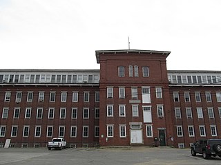
The Arlington Mills Historic District encompasses a major 19th century textile manufacturing complex in Lawrence and Methuen, Massachusetts. Developed between 1865 and 1925, it was one of the state's largest textile operations at its height. At the time of its listing on the National Register of Historic Places in 1985, the mill complex was owned by Malden Mills.

The North Canal Historic District of Lawrence, Massachusetts, encompasses the historic industrial heart of the city. It is centered on the North Canal and the Great Stone Dam, which provided the waterpower for its many mill complexes. The canal was listed on the National Register of Historic Places in 1975, while the district was first listed in 1984, and then expanded slightly in 2009.

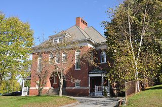
The Pleasant–High Historic District encompasses the earliest area of non-agricultural residential development in Methuen, Massachusetts. It encompasses houses along High and Pleasant Streets from just east of Broadway to Vine Street, as well as a few that face on adjoining streets. The district was listed on the National Register of Historic Places in 1984; on its western boundary it abuts the Spicket Falls Historic District.

Henry Coffin Nevins was an industrialist from an established New England family in the city of Methuen, Massachusetts.

The Central Mills Historic District encompasses a historic mill complex on the Quinebaug River in central Southbridge, Massachusetts. Located at the corner of Foster and North Streets, the site consists of three brick buildings, the oldest of which has portions dating to 1837. Despite being extensively rebuilt in the early 20th century, the complex has an appearance that is more typical of 19th century mills.

The Hamilton Woolen Company Historic District encompasses the well preserved "Big Mill" complex of the Hamilton Woolen Company, built in the mid 19th century. Located at the confluence of McKinstry Brook and the Quinebaug River in central Southbridge, Massachusetts, the complex consists of a cluster of mill buildings and a rare collection of 1830s brick mill worker housing units located nearby. The district was listed on the National Register of Historic Places in 1989.

The Exeter Waterfront Commercial Historic District encompasses the historic commercial and residential waterfront areas of Exeter, New Hampshire. The district extends along the north side of Water Street, roughly from Main Street to Front Street, and then along both sides of Water and High streets to the latter's junction with Portsmouth Street. It also includes properties on Chestnut Street on the north side of the Squamscott River. This area was where the early settlement of Exeter took place in 1638, and soon developed as a shipbuilding center. The district was listed on the National Register of Historic Places in 1980. It was enlarged in 1986 to include the mill complex of the Exeter Manufacturing Company on Chestnut Street.
The Salmon Falls Mill Historic District encompasses a historic mill complex on Front Street in Rollinsford, New Hampshire. The complex includes four major structures and seven smaller ones, on about 14 acres (5.7 ha) of land along the Salmon Falls River. They were built between about 1840 and the mid-1860s, and have an unusual architectural unity, for additions made to the buildings were done with attention to matching design elements from the existing structures. The Number 2 Mill, built in 1848, was an early location where a turbine was used instead of a waterwheel to provide power to the mill machinery. The district was listed on the National Register of Historic Places in 1980.
The Lewiston Mills and Water Power System Historic District encompasses the major 19th-century mill complexes and associated water power systems in Lewiston, Maine. Developed beginning in 1850, Lewiston's canals and mills were the largest textile mill complex in the state, and one of the best-preserved mature large-scale expressions of the Lowell system of cotton textile manufacturing, perfected at Waltham and Lowell, Massachusetts earlier in the 19th century. The district includes a series power canals and mill complexes developed over a 100-year period, along with mill worker housing and transportation infrastructure. It was listed on the National Register of Historic Places in 2015.

The Manchaug Village Historic District is a historic district encompassing the 19th century industrial village center of Manchaug in Sutton, Massachusetts. Developed in the 1820s around textile mills on the Mumford River, it was the largest industrial area in Sutton, with at least three mill complexes in operation. The district is centered on the junction of Main Street with Manchaug, Putnam Hill, and Whitins Roads.


