Spiti Valley

Last updated

Spiti Valley
Spiti
Spiti River Kaza Himachal Jun18 D72 7232.jpg
Spiti River upstream of Kaza
Floor elevation2,950–4,100 m (9,680–13,450 ft) [1]
Geography
Location Lahaul and Spiti district
State/Province Himachal Pradesh, India
Population centersLosar, Kaza, Tabo, Sumdo, Chango
View of Spiti Valley and Key Monastery in winter, Jan. 2008 Kee monastery Spiti Valley (edited).jpg
View of Spiti Valley and Key Monastery in winter, Jan. 2008

Spiti Valley (pronounced as Piti in Bhoti Language) is a cold desert mountain valley located high in the Himalayas in the north-eastern part of the northern Indian state of Himachal Pradesh. The name "Spiti" means "The middle land", i.e. the land between Tibet and India. [2]

Contents

The local population follows Vajrayana Buddhism similar to that found in the nearby Tibet and Ladakh regions. The valley and surrounding region are among the least populated regions in India. Spiti valley is a gateway to the northernmost reaches of the nation. Spiti forms part of the Lahaul and Spiti district. The sub-divisional headquarters (capital) is Kaza, [3] which is situated on the bank of the Spiti River at an elevation of about 12,500 feet (3,800 m).

Spiti valley is surrounded by high mountain ranges. Spiti valley is separated from Lahaul valley by the high Kunzum Pass, at 15,059 feet (4,590 m). [3] A road connects these two divisions of Lahaul and Spiti district, but is cut off frequently in winter and spring due to heavy snow. A southern route to India proper, via the Sutlej in the Kinnaur district and Shimla, is periodically closed for brief periods in the winter storms of November through June, but road access is usually restored a few days after the storm ends.

History

Tabo Monastery viewed from monks' caves TaboMonastery-Tabo-Spiti-Himachal-D72 6768.JPG
Tabo Monastery viewed from monks' caves

It is believed that Spiti came into existence as a principality after the decline of central power in India as was the case with Lahaul. Local rulers had the title of Nonos. They were either descendants of a native family of Spiti or chiefs sent to look after the affairs of Spiti by the rulers of Ladakh. In the 10th century, Spiti was part of the kingdom of Ngari Khorsum established by Kyide Nyimagon of the Tibetan Royal lineage. After his death, Zanskar and Spiti were given to his youngest son Detsukgon, while the eldest son Lhachen Palgyigon became the King of Ladakh. After that, the history of Spiti was linked with the history of Ladakh for a long time. This region became autonomous whenever the rulers of Ladakh were weak. However the rulers of Spiti periodically sent tributes to Ladakh, Chamba and Kullu. [4]

Spiti became practically free after the Tibet–Ladakh–Mughal War of 1679-83. This prompted Man Singh, Raja of Kullu, to invade Spiti and establish a loose control over this principality. Later on, in the 18th century, control once again passed back to Ladakh. An official was sent from Leh as Governor, but he usually went away after the harvest time, leaving the local administration in the hands of the Wazir or Nono. There was a headman for a group of villages for day-to-day administrative affairs. [4]

Spiti briefly came under the Dogra rule (as part of the Sikh Empire) between 1842 and 1846, after which it was annexed to the British Empire.. Mansukh Das, hereditary Wazir of Bushahr, was entrusted with the local administration of this region from 1846-48. The Wazir had to pay the British revenue of only Rs. 700 annually for the whole of Spiti. In 1849, Spiti came directly under the control of the Assistant Commissioner, Kooloo (Kullu). [5] Kooloo was a sub-division of Kangra district, Punjab. In 1941, Spiti was made part of the Lahaul tehsil (sub-division) of Kullu district, with its headquarters at Keylong. After the formation of Lahaul & Spiti into a district in 1960, Spiti was formed into a sub-division with its headquarter at Kaza. [6] Lahaul and Spiti district was merged with Himachal Pradesh on 1 November 1966 on enactment of the Punjab Reorganisation Act.

Culture

Huge mani stone in the Spiti Valley, India Spiti - huge mani stone.jpg
Huge mani stone in the Spiti Valley, India

The local population follows Vajrayana Buddhism similar to that found in the nearby Tibet and Ladakh regions. Spiti valley is a research and cultural centre for Buddhists. Highlights include Key Monastery and Tabo Monastery, one of the oldest monasteries in the world and a favourite of the Dalai Lama. [7] It was the location of the scenery and cinematography in the Indian films Paap , Highway [ disambiguation needed ] and Milarepa , a biographical adventure tale about one of Buddhism's most famous Tibetan saints. The Buddhist monastery in the valley served as the locus of the set and some of the monks appeared in the film. The Pin Valley of Spiti is home to the few surviving Buchen Lamas of the Nyingmapa sect of Buddhism.

Spiti is a summer home to hundreds of semi-nomadic Gaddi sheep and goat herders who come to this valley for grazing their animals from the surrounding villages and sometimes as far as 250 km (160 mi). They enter the valley during summer as the snow melts and leave just a few days before first snowfall of the season.

Transport

Deep gorge in alluvium bed, Spiti River, and NH-505, Jun '18 NH505 Spiti Kaza Losar Jun18 D72 7797.jpg
Deep gorge in alluvium bed, Spiti River, and NH-505, Jun '18

Spiti valley is accessible throughout the year via Kinnaur from Shimla on a difficult 412-kilometre-long (256 mi) road. Tourists from outside India need inner line permits to enter Spiti through Kinnaur. Spiti's border starts at Samdo (74 km (46 mi) from Kaza) which is quite near to the India–China border. In summer it can be reached via Manali through the Atal tunnel and Kunzum Pass. Kaza, the headquarters of the Spiti subdivision, is 201 km (125 mi) from Manali. The road joining Manali to Spiti is treacherous and in bad condition as compared to the Shimla to Spiti road.

Due to the high altitude one is likely to feel altitude sickness in Spiti. The Shimla to Spiti route is advised for travelers coming from lower altitudes as it gives them enough time to get acclimatized to the high altitude. This is because the road runs parallel to the Sutlej river initially, climbing steadily to 2,550 metres (8,370 ft) at the confluence of the Spiti and Satluj near Khab. From Khab, NH-505 runs along the Spiti River, climbing steeply up to Nako (elev. 3,620 metres (11,880 ft)) before continuing to Kaza. NH-505 enters Lahaul at Kunzum La.

Geography

The Spiti emerges from a gorge to merge into the Satluj near Khab, Jun '18 Confluence Spiti Satluj Jun18 D72 6744.jpg
The Spiti emerges from a gorge to merge into the Satluj near Khab, Jun '18
Barren, high mountains with sparse vegetation along Spiti tributary near Kunzum Pass Losar-Kunzum Road Jun18 D72 7836.jpg
Barren, high mountains with sparse vegetation along Spiti tributary near Kunzum Pass

The Spiti River originates from the Kunzum range. Tegpo and Kabzian streams are two of its tributaries. Water draining the famous Pin Valley National Park is also a part of the Spiti river system. Its position across the main Himalayan range deprives it from the benefit of the South-West monsoons that causes widespread rain in most parts of India from June to September. The river attains peak discharge in late summers due to glacier melting. After flowing through Spiti valley, the Spiti River meets the Satluj near Khab and Namgia in Kinnaur district traversing a length of about 150 km from the North-West. [8] Steep mountains rise to very high altitudes on either side of the Spiti River and its numerous tributaries. The mountains are barren and largely devoid of vegetative cover. The main settlements along the Spiti River and its tributaries are Kaza and Tabo.

Over millenia, the Spiti River and its tributaries such as the Pin River, have cut deep gorges in the uplifted sedimentary strata. With little rain or snow there is not much of weathering of the steep valley sides. As vegetation is sparse, the rock strata in the steep cliffs are easily visible to the geologist, without excavation or drilling. Thomson during his 1847 expedition noted 3 forms of alluvia in the Spiti valley. The first is deposits of fine clay. The second is triangular platforms that slope gently from the mountains to the river, usually ending in a steep cliff. The third are enormous masses of great depth, 400–600 ft (120–180 m) above the river bed. The river has cut deep gorges through these platforms. The latter two consist of clay, pebbles and boulders. Thomson speculated that the valley appeared to have been a lake bed in the past though he could not conceive mechanisms to explain the phenomena. [9]

Now, we know that the valley was uplifted from the ocean bed due to the movement of tectonic plates. [10] . The Moravian geologist Ferdinand Stoliczka discovered a major geological formation near Mud village in Spiti in the 1860s. Stoliczka identified a number of layers or successions, one of which he named as the Muth succession. [11] This was later renamed as the Muth System by Hayden (1908) and as the Muth Formation by Srikantia (1981). [12] For more details, see the Geology of Mud village.

Places to visit in Spiti Valley

Kibber village. Jun '18 Kibber Spiti Himachal Jun18 D72 7488.jpg
Kibber village. Jun '18
Pin valley in Spiti Pin Valley, Spiti.jpg
Pin valley in Spiti

Places to visit include these: [13] [14]

Best time to visit Spiti Valley

The best time to visit Spiti Valley is May to October. During this summer season, Spiti is accessible from Manali and from Shimla. In winters the road from Manali is closed for almost 6 months due to heavy snowfall. Spiti is accessible during most of the winter from Shimla. Besides tourists, many film-makers visit Spiti in winter for shooting. [15] In winter 2021-22, national ice-hockey and ice-skating championships were held in Kaza. [16]

See also

Related Research Articles

Kullu district District of Himachal Pradesh, India

Kullu is a district in Himachal Pradesh, India. The district lies in central Himachal and is famous for its tourist stations and Himalayan Treks connecting the trails with far remote regions between the adjacent districts of Lahaul and Spiti, Kinnaur ,Shimla, Mandi and Kangra districts which are bordered at North - North East, East, south, West and South Of Kullu respectively. The District is also a home to some of the Ancient settlements, Traditional Handloom and Apple Cultivation. It stretches from the Town of Rampur in the south to the Rohtang Pass in the North. The Main Kullu Valley which falls between the Pir Panjal Himalayas and Northern Edge Of The Dhauladhar or Bhangal Region lies at an elevation ranging from as less as 833 M to 3330 M from Aut Tunnel North Portal to Atal Tunnel South Portal On NH 3 and NH 505.

Rohtang Pass Mountain pass

Rohtang Pass is a high mountain pass on the eastern end of the Pir Panjal Range of the Himalayas around 51 km (32 mi) from Manali in the Indian state of Himachal Pradesh. It connects the Kullu Valley with the Lahaul and Spiti Valleys of Himachal Pradesh, India.

Lahaul and Spiti district District of Himachal Pradesh in India

The Lahaul and Spiti district in the Indian state of Himachal Pradesh consists of the two formerly separate districts of Lahaul and Spiti. The present administrative centre is Kyelang in Lahaul. Before the two districts were merged, Kardang was the capital of Lahaul, and Dhankar the capital of Spiti. The district was formed in 1960, and is the fourth least populous district in India . It is the least densely populated district of India, according to the Census of India 2011.

Manali, Himachal Pradesh Town in India

Manali is a town in the Indian state of Himachal Pradesh. It is situated in the northern end of the Kullu Valley, formed by the Beas River. The town is located in the Kullu district, approximately 270 kilometres (170 mi) north of the state capital of Shimla and 544 kilometres (338 mi) northeast of the national capital of Delhi. With a population of 8,096 people recorded in the 2011 Indian census Manali is the beginning of an ancient trade route through Lahaul and Ladakh, over the Karakoram Pass and onto Yarkand and Hotan in the Tarim Basin of China. Manali is a popular tourist destination in India and serves as the gateway to the Lahaul and Spiti district as well as the city of Leh in Ladakh.

Tabo, Himachal Pradesh Town and village in Himachal Pradesh, India

Tabo is a small town in the Lahaul and Spiti district on the banks of the Spiti River in Himachal Pradesh, India. The town lies on the road between Rekong Peo and Kaza, the sub-divisional headquarters of Spiti. The town surrounds a Buddhist monastery which, according to legend, is said to be over a thousand years old. The Dalai Lama has expressed his desire to retire to Tabo, since he maintains that the Tabo Monastery is one of the holiest. In 1996, the Dalai Lama conducted the Kalachakra initiation ceremony in Tabo, which coincided with the millennium anniversary celebrations of the Tabo monastery. The ceremony was attended by thousands of Buddhists from across the world. Tabo Monastery's spiritual head is Tsenshap Serkong Rinpoche.

Kullu Town in Himachal Pradesh, India

Kullu is a municipal council town that serves as the administrative headquarters of the Kullu district of the Indian state of Himachal Pradesh. It is located on the banks of the Beas River in the Kullu Valley about 10 kilometres (6.2 mi) north of the airport at Bhuntar.

Geography of Himachal Pradesh

The state of Himachal Pradesh is spread over an area 55,673 km2 (21,495 sq mi) and is bordered by Jammu and Kashmir and Ladakh on the north, Punjab on the southwest, Haryana on the south, Uttarakhand on the southeast, a small border with Uttar Pradesh in the south, and Tibet on the east. Entire Himachal Pradesh lies in the mountainous Himalaya region, rich in natural resources

Dhankar Gompa

Dhankar Gompa is a village and also a Gompa, a Buddhist temple in the district of Lahaul and Spiti in India. It is situated at an elevation of 3,894 metres in the Spiti Valley above Dhankar Village, between the towns of Kaza and Tabo. The complex is built on a 1000-foot (300-metre) high spur overlooking the confluence of the Spiti and Pin Rivers - one of the world's most spectacular settings for a gompa. Dhang or dang means cliff, and kar or khar means fort. Hence Dhangkar means fort on a cliff.

The development of tribal areas in Himachal Pradesh is one of the major steps taken by the state government for its economic development. The border districts of Kinnaur, Lahaul, Spiti and the Pangi and Bharmour tehsils of Chamba districts are the major tribal areas of the state. They are located near the borders of Tibet and Indian States of Jammu and Kashmir. Other backward areas include Shillai in Sirmaur district, and deep cut-off valleys in the Kullu and upper stretches of Kangra districts. Due to poor accessibility, life in these areas had grown in isolation.

Key Monastery Monastery in Spiti, Himachal Pradesh, India

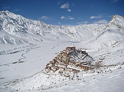
Kye Gompa is a Tibetan Buddhist monastery of the Gelugpa sect located on top of a hill at an altitude of 4,166 metres (13,668 ft) above sea level, close to the Spiti River, in the Spiti Valley of Himachal Pradesh, Lahaul and Spiti district, India.

Khab Village in Himachal Pradesh, India

Khab is a small village in the state of Himachal Pradesh, India. It is located in the Sutlej river valley near the India-Tibet border. National Highway 5 connects Khab with state capital Shimla. Khab sangam is the confluence of Spiti river and Sutlej river. The Spiti river flowing through the spiti valley here meets the Sutlej, which originates from Mansarovar Lake in Tibet. The ancient monastery of Tashigang Gompa is nearby. The peak of Reo Purgil, which rises to 22,400 feet (6,800 m), is visible and the cold desert of Spiti lies across the nearby bridge.

Kaza, Himachal Pradesh Town in Himachal Pradesh, India

Kaza, also spelled Kaze, Karze, Karzey, is a town and the subdivisional headquarters of the remote Spiti Valley in the western Himalayas in the Lahaul and Spiti district of the northern Indian state of Himachal Pradesh. Spiti is a high altitude or cold desert having close similarities to the neighbouring Tibet and Ladakh regions in terms of terrain, climate and the Buddhist culture. Kaza, situated along the Spiti River at an elevation of 3,650 metres (11,980 ft) above mean sea level, is the largest township and commercial center of the Spiti valley.

Buddhism in Himachal Pradesh

Buddhism in the Indian state of Himachal Pradesh has been a long recorded practice. The spread of Buddhism in the region has occurred intermediately throughout its history. Starting in the 3rd century BCE, Buddhism was propagated by the Maurya Empire under the reign of Ashoka. The region would remain an important center for Buddhism under the Kushan Empire and its vassals. Over the centuries the following of Buddhism has greatly fluctuated. Yet by experiencing revivals and migrations, Buddhism continued to be rooted in the region, particularly in the Lahaul, Spiti and Kinnaur valleys.

Western Himalayas Western section of the Himalayas

The Western Himalayas refers to the western half of the Himalayas, in northern Pakistan and northwestern India. It is also known as the Punjab Himalayas. Four of the five tributaries of the Indus River in Punjab rise in the Western Himalayas; while the fifth, the Sutlej cuts through the range after rising in Tibet.

Tourism in Himachal Pradesh Tourism in the Indian state of Himachal Pradesh

Tourism in Himachal Pradesh relates to tourism in the Indian state of Himachal Pradesh. This is popularly renowned for its Himalayan landscapes and popular hill-stations. Many outdoor activities such as rock climbing, mountain biking, paragliding, ice-skating, trekking, rafting, and heli-skiing are popular tourist attractions in Himachal Pradesh.

National Highway 505 (India) National Highway in Himachal Pradesh, India

National Highway 505, commonly called NH 505, is a national highway in India. It is a spur road of National Highway 5. NH-505 traverses the state of Himachal Pradesh in India. NH505 a high altitude road, covers Kinnaur and Lahaul and Spiti districts of Himachal Pradesh, mainly running along Spiti river in Spiti valley. The highway from Kaza to Gramphu remains closed for 6–9 months in a year due to heavy snowfall and closure of Kunzum La pass at an altitude of 4,550 m (14,930 ft).

Gue (Lahul and Spiti) Village in Lahul and Spiti District, Himachal Pradesh, India

Gue is a village in the Lahul & Spiti district of the state of Himachal Pradesh in India. In this little village lays the perfectly well-preserved 500-year-old mummy of Sangha Tenzing. It was a Buddhist monk from Tibet. It was found in a sitting position, with his skin and hair intact. The village is about 40 km from the Tabo Monastery. The latitude 31.11 and longitude 77.16 are the geocoordinate of the Gue. Current Gue is controlled by India but claimed by Zanda County, Ngari Prefecture, Tibet, China.

Kaurik is village in the Lahul and Spiti district, in Himachal Pradesh, India. It is in the valley of the Parang River before its confluence with the Spiti River. It is close to the border with Tibet. The Tibetan village on the opposite of the border is Tsurup Sumgyi. Current Kaurik is controlled by India but claimed by Zanda County, Ngari Prefecture, Tibet, China.

Losar Khas Government office in Himachal Pradesh

Losar Khas or Losar is a village on the right bank of the Spiti River in District Lahaul Spiti in the state of Himachal Pradesh, India. The Losar Gram Panchayat located in Losar is a local government body for the village of Losar Khas and 12 nearby villages in Development Block Spiti.

Mud village, Spiti Village in Himachal Pradesh, India

Mud is a small village in the cold desert region of Spiti in Himachal Pradesh, India. Located at an altitude of 3,810 m (12,500 ft) on the left bank of the Pin River, a right bank tributary of the Spiti River, the village nestles at the base of the Parbati range that towers almost vertically 1,600 m (5,200 ft) above. Mud is near the boundary of the Pin Valley National Park and is a convenient base for treks in the park, and to the neighbouring districts of Kullu and Kinnaur. It is the last village on the Spiti side of the Pin Parbati trek to Kullu and the Pin Bhaba trek to Kinnaur.

References

  1. "Losar - Chango, OpenStreetMap". OpenStreetMap. Retrieved 31 August 2020.
  2. Kapadia (1999), p. 209.
  3. 1 2 "Himachal Tourism - Lahaul & Spiti District". Department of Tourism & Civil Aviation, Government of Himachal Pradesh. Archived from the original on 10 June 2008. Retrieved 28 September 2008.
  4. 1 2 Kapadia (1999), Ch. 2.
  5. Harcourt, A.F.P. (1871). The Himalayan Districts of Kooloo, Lahoul and Spiti. London: W.H. Allen & Sons. p. 132.
  6. "District Lahaul and Spiti: History". Government of Himachal Pradesh . Retrieved 15 October 2021.{{cite web}}: CS1 maint: url-status (link)
  7. "Lahaul & Spiti District, Himachal Pradesh, India". District Lahaul & Spiti, Government of India. Archived from the original on 23 July 2008.
  8. "Khab, Himachal, OpenStreetMap.org". OpenStreetMap.org. Retrieved 14 June 2020.
  9. Thomson, Thomas (1852). Western Himalayas and Tibet. London: Reeve and Co. pp. 27, 123–124.
  10. "Plate tectonics: Formation and break-up of continents". Wikipedia . Retrieved 13 January 2022.{{cite web}}: CS1 maint: url-status (link)
  11. Stoliczka, F. (1866). "Geological Sections across the Himalayan Mountains from Wangtu Bridge on the River Sutlej to Sungdo on the Indus, with an account of the formations in Spiti, accompanied by a revision of all known fossils from that district". Memoirs of the Geological Survey of India. Geological Survey of India. V: 1–154.
  12. Parcha, S.K.; Pandey, Shivani (September 2011). "Devonian Ichnofossils from the Farakah Muth Section of the Pin Valley, Spiti Himalaya". Journal Geological Society of India. Bangalore: Geological Society of India. 78: 263–270.
  13. "Places to Visit in Spiti Valley | Welcome to the Heaven!". Being Himalayan. 3 February 2019. Retrieved 22 March 2019.
  14. "Spiti Valley Circuit Tour". Raacho Trekkers. 21 April 2022. Retrieved 21 April 2022.
  15. Sharma, Ashwani (3 December 2021). "Himachal Wakes Up To Blanket Of Snow In Lahaul-Spiti, Winter Rain Freezes Shimla". Outlook (Indian magazine) . Retrieved 18 July 2022.
  16. Bisht, Gaurav (16 July 2022). "Himachal govt sets up highest gym at Kaza in Spiti valley". Hindustan Times .

Bibliography

Coordinates: 32°17′N78°00′E / 32.283°N 78.000°E / 32.283; 78.000