
Helper is a city in Carbon County, Utah, United States, approximately 110 miles (180 km) southeast of Salt Lake City and 7 miles (11 km) northwest of the city of Price. It is known as the "Hub of Carbon County". The population was 2,201 at the 2010 census.

Thistle is a ghost town in Spanish Fork Canyon in southeastern Utah County, Utah, United States. During the era of steam locomotives, the town's primary industry was servicing trains for the Denver and Rio Grande Western Railroad. The fortunes of the town were closely linked with those of the railroad until the changeover to diesel locomotives, when the town started to decline.

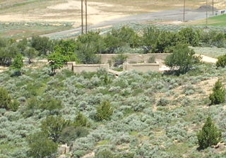
Castle Gate is a ghost town located in Carbon County in eastern Utah, United States. Castle Gate was a mining town approximately 90 miles (140 km) southeast of Salt Lake City. The name of the town was derived from a rock formation near the mouth of Price Canyon. This formation features two sheer sandstone walls on either side of the Price River, which appear to open like a giant gate as travelers approach this narrow section of the canyon.
Tono, Washington is a ghost town in Southwest Washington. It was a company-owned mining town founded in 1907 by the Washington Union Coal Company, a subsidiary of the Union Pacific Railroad to supply coal for their steam locomotives. Tono was located in southern Thurston County about 20 miles south of Olympia, Washington, 5 miles south of Tenino, 2 miles east of Bucoda at the end of a railroad spur. The town was named Tono in 1909 by one of the many Japanese railroad workers. Folk etymology states the name is a contraction of "ton of coal".

Mohrland is a ghost town located in Emery County, Utah, United States. Lying in Cedar Creek Canyon near the Carbon County line, Mohrland was Emery County's largest coal mining town, with a history more typical of Carbon County's coal camps than of most Emery County communities.

Sego is a ghost town in Grand County, Utah, United States. It lies in the narrow, winding Sego Canyon, in the Book Cliffs some 5 miles (8.0 km) north of Thompson Springs. Formerly an important eastern Utah coal mining town, Sego was inhabited about 1910–1955. The town is accessed via the grade of the Ballard & Thompson Railroad, a spur from the Denver and Rio Grande Western built by the founders of the town to transport the coal.

Clear Creek is a census-designated place on the western edge of Carbon County, Utah, United States. It is located at the south end of State Route 96 and the Pleasant Valley Branch of the Union Pacific Railroad (ex-D&RGW).
The Ghost Town Trail is a rail trail in Western Pennsylvania that stretches 36 miles (58 km) from Black Lick, Indiana County, to Ebensburg, Cambria County. Established in 1991 on the right-of-way of the former Ebensburg and Black Lick Railroad, the trail follows the Blacklick Creek and passes through many ghost towns that were abandoned in the early 1900s with the decline of the local coal mining industry. Open year-round to cycling, hiking, and cross-country skiing, the trail is designated as a National Recreation Trail by the United States Department of the Interior.
Grass Creek is a ghost town in Summit County, Utah, United States. Lying some 8 miles (13 km) northeast of Coalville, it was once an important coal mining town. Grass Creek was inhabited circa 1860–1940.

Silver City is a ghost town located at the mouth of Dragon Canyon on the west flank of the East Tintic Mountains in northeast Juab County in central Utah, United States. It was a silver mining town approximately 90 miles (140 km) south-southwest of Salt Lake City. This area was considered part of the Tintic Mining District and also produced bismuth, copper, gold, and lead. Settlement began with the first mining strikes here in 1869. Silver City was inhabited until 1930, after the mines played out. Jesse Knight, known as the "Mormon Wizard" for his ability to find ore easily, decided to build a smelter in Silver City because it had the flattest ground in all of the Tintic Mining District. Silver City had several mines in 1890, but the mines hit water and were abandoned. Now there is little left other than a few holes where mines were, and a number of tailings piles. The Silver City Cemetery, however, survives and is listed on the National Register of Historic Places.
Knightsville is a ghost town located in the East Tintic Mountains on the northern slope of Godiva Mountain, approximately 2 miles (3.2 km) east of Eureka, in the northeastern corner of Juab County in central Utah, United States. A silver mining camp, Knightsville was established and operated as a company town by local mining entrepreneur Jesse Knight. The town was inhabited from 1896 until approximately 1940.

Standardville is a ghost town in Carbon County, Utah, United States. Standardville was established after coal was discovered in the area in 1912. The layout of the town was so well-planned, it became the "standard" for all mining towns to follow, which resulted in the town name of Standardville. In 1922, a group of striking miners killed a mine guard and wounded two miners before escaping. In 1930, 20 miners were killed in a mine explosion caused by carbon monoxide gas. In 1950, the mine shut down and people began to relocate elsewhere. A couple families remained until the 1970s, after which Standardville was abandoned.
Coal City is a ghost town in Carbon County, Utah, United States. Established in 1885, Coal City was initially a farming community until coal was discovered in the area. Small-scale mining began to take place, and because the mining operations were a mile or two away from the mines at National and Consumers, it was assumed that the citizens of the town would lack workplace stress. Coal production began to decline in 1935, and the town was essentially abandoned with just two residences occupied by the late 1960s.
Winter Quarters is a ghost town in Carbon County, Utah, United States. Coal was discovered in the area in 1875, and later that year, the Pleasant Valley Coal Company began coal mining operations. A group of coal miners were delayed during an early winter storm in 1877, which led to the town's name of Winter Quarters. On May 1, 1900, an explosion in the Winter Quarters Number Four mine killed 200 miners. Despite the mine explosion, the coal mining operations remained active until 1922, when the opening of a new mine in Castle Gate caused many people to relocate there. By 1930, Winter Quarters was abandoned.
Peerless is a ghost town in Carbon County, Utah, United States. It is located just 3 miles (4.8 km) west of Helper.
Dragon is a ghost town in Uintah County, at the extreme eastern edge of Utah, United States. Founded in about 1888 as a Gilsonite mining camp, Dragon boomed in the first decade of the 20th century as the end-of-line town for the Uintah Railway. Although it declined when the terminus moved farther north in 1911, Dragon survived as the largest of the Gilsonite towns. It was abandoned after its mining operations stopped in 1938 and the Uintah Railway went out of business in 1939.

The Knight–Allen House is a historic house located in Provo, Utah. It is listed on the National Register of Historic Places.

The Knight Block is a historic building located on South University Avenue in downtown Provo, Utah, United States. It is listed on the National Register of Historic Places.
Morley was a town in Las Animas County, Colorado, that existed between 1878 and 1956. The town was located near the summit of Raton Pass and was originally a railroad stop before being developed into a coal mining town by the Colorado Fuel and Iron Company (CF&I). Morley was a CF&I company town for fifty years until 1956 when the mine was closed and the town demolished.

Cambria (1889-1928) is a ghost town located in the Black Hills of Weston County, Wyoming, United States. It was a successful coal mining town for decades.


