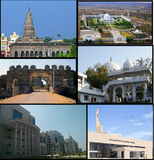
Kalaburagi, also known as Gulbarga, is a city in the Indian state of Karnataka. It is the administrative headquarters of the Kalaburagi district and is the largest city in the region of North Karnataka (Kalyana-Karnataka). Kalaburagi is 623 km north of the state capital city of Bangalore. It was incorporated into the newly formed Mysore State through the States Reorganisation Act in 1956.

The Deccan Plateau is a large plateau in southern India between the Western Ghats and the Eastern Ghats, and loosely defined as the peninsular region between these ranges that is south of the Narmada river. A rocky terrain marked by boulders, it ranges between 100 metres (330 ft) and 1,000 metres (3,300 ft), with an average elevation of about 600 metres (2,000 ft).

The Deccan sultanates were five late-medieval Indian kingdoms—on the Deccan Plateau between the Krishna River and the Vindhya Range—that were ruled by Muslim dynasties: namely Ahmadnagar, Berar, Bidar, Bijapur, and Golconda. The sultanates had become independent during the break-up of the Bahmani Sultanate. In 1490, Ahmadnagar declared independence, followed by Bijapur and Berar in the same year. Golconda became independent in 1518, and Bidar in 1528.

Bijapur, now officially called Vijayapura, is the district headquarters of Vijayapura district of the Karnataka state of India. It is also the headquarters for Vijayapura Taluka. Bijapur city is well known for its historical monuments of architectural importance built during the rule of the Adil Shahi dynasty. It is also well known for the sports by the popular Karnataka premier league team as Bijapur Bulls. Bijapur is located 530 km (330 mi) northwest of the state capital Bangalore and about 550 km (340 mi) from Mumbai and 384 km (239 mi) west of the city of Hyderabad.

The Bahmani Sultanate was a Persianate Sunni Muslim empire of the Deccan in South India. It was the first independent Muslim kingdom of the Deccan, and was known for its perpetual wars with its Hindu rivals of Vijayanagara, which would outlast the Sultanate.

Bidar is a city in the north-eastern part of Karnataka state in India. It is the headquarters of the Bidar district which borders Maharashtra and Telangana. It is a rapidly urbanising city in the wider Bidar Metropolitan area. The city is well known for its many sites of architectural, historical and religious importance.

Raichur District is an administrative district in the Indian state of Karnataka. It is located in the northeast part of the state and is bounded by Yadgir district in the north, Bijapur and Bagalkot district in the northwest, Koppal district in the west, Bellary district in the south, Jogulamba Gadwal district of Telangana and Kurnool district of Andhra Pradesh in the east.

Kalaburagi district, formerly known as Gulbarga district, is one of the 31 districts of Karnataka state in southern India. Kalaburagi city is the administrative headquarters of the district. The district is the headquarters of Kalaburagi division.

Uttara Karnataka, is a geographical region in Deccan plateau from 300 to 730 metres elevation that constitutes the region of the Karnataka state in India and the region consists of 13 districts. It is drained by the Krishna River and its tributaries the Bhima, Ghataprabha, Malaprabha, and Tungabhadra. North Karnataka lies within the Deccan thorn scrub forests ecoregion, which extends north into eastern Maharashtra. Most parts of the region has black fertile soil ideal for agriculture.
Basavakalyana is a City and municipal council in the Bidar District of the Indian state of Karnataka.

The history of Karnataka goes back more than two millennia. Several great empires and dynasties have ruled over Karnataka and have contributed greatly to the history, culture and development of Karnataka
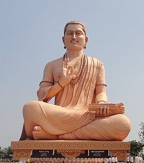
Religion in Karnataka has played a very important role in shaping modern Indian religions and philosophy.

Malkheda, also known as Malkhed, is a town in Karnataka, India. It is located on the banks of Kagina River in Sedam Taluk of Kalaburagi district, around 40 km from Kalaburagi.

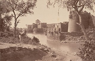
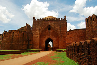
Bidar Fort is a fort at Bidar, Karnataka, India. The fort, the city and the district are all affixed with the name Bidar. Sultan Ahmad Shah I of the Bahmanid Dynasty shifted his capital from Gulbarga to Bidar in 1427 and built his fort along with a number of Islamic monuments. There are over 30 monuments inside Bidar fort.
The Gulbarga Fort is located in Kalaburagi in the Kalaburagi district of North Karnataka. It was subsequently significantly enlarged in 1347 by Al-ud-din Hasan Bahmani of the Bahmani Dynasty after he cut off his ties with the Delhi Sultanate; Islamic monuments such as mosques, palaces, tombs, and other structures were also built later within the refurbished fort. The Jama Masjid built later, within the fort, in 1367, is a unique structure built in Persian architectural style, fully enclosed, with elegant domes and arched columns, which is unlike any other mosque in India. It was built to commemorate the establishment of the dynastic rule of the Bahmani kingdom at Kalaburagi fort between 1327 and 1424. It remained the capital of the Bahmani Kingdom till 1424 where after the capital was shifted to Bidar Fort, as Bidar had better climatic conditions.

The name Karnataka is derived from Karunadu, meaning "lofty land" or "high plateau," due to its location on the Deccan Plateau. The name can also mean "land of black soil" in Kannada. The recorded history of Karnataka goes back to the Ramayana and Mahabharata epics. The capital of "Baali" and "Sugriva" referenced in the Ramayana is said to be Hampi. Karnataka is mentioned in the Mahabharata as "Karnata Desha." Historically, the region was also called "Kuntala Rajya."
The history of Telangana, located on the high Deccan Plateau, includes its being ruled by the Satavahana Dynasty, the Kakatiya Dynasty (1083–1323), the Musunuri Nayaks (1326–1356), the Delhi Sultanate, the Bahmani Sultanate (1347–1512), Golconda Sultanate (1512–1687) and Asaf Jahi dynasty (1724-1950).
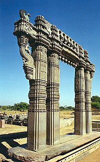
Deccani Architecture refers to the architectural styles developed during the Deccan sultanate period. The Deccan sultanates were five dynasties that ruled late medieval kingdoms, namely, Bijapur, Golkonda, Ahmadnagar, Bidar, and Berar in south-western India. The Deccan sultanates were located on the Deccan Plateau. Their architecture was a regional variant of Indo-Islamic architecture, heavily influenced by the styles of the Delhi Sultanate and later Mughal architecture, but sometimes also directly from Persia and Central Asia.

Warangal district, formerly Warangal Rural district, is a district in the Indian state of Telangana. The district shares boundaries with Mahabubabad, Jangaon, Hanamkonda, Mulugu and Bhupalpally districts. As of June 2021, Hanamkonda tentatively serves as the district headquarters of both Hanamkonda and Warangal districts. Warangal is proposed to replace Hanamkonda as the new headquarters of the Warangal district.