
Jama Masjid is a mosque in Srinagar, Jammu and Kashmir, India. Situated at Nowhatta in the Old City, the Mosque was commissioned by Sultan Sikandar in 1394 CE and completed in 1402 CE, at the behest of Mir Mohammad Hamadani, son of Mir Sayyid Ali Hamadani, and is regarded as one of the most important mosques in Kashmir. The mosque is located downtown, a central zone in the religio-political life in Srinagar. Thronged by Muslims every Friday, it is a prime tourist attractions of Srinagar.
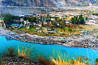
Bandipore or Bandipora is the headquarters of district of Bandipore in the union territory of Jammu and Kashmir, India. It is located on the northern banks of Wullar Lake—the second-largest freshwater lake in Asia. Bandipora has a terraced garden similar to that of Nishat Bagh in Srinagar. Bandipora is bound by mountains on three sides and by Wular Lake on the fourth. As per folklore, the name of Bandipora originated either from Bund of Wular as Bund e pur, from the local folk-singing bands (bāṇd) as Baand e pur or from the enclosed (band) geographical location as Bandh e pur.
Nowshera is a town and the headquarters of an eponymous tehsil of Rajouri district in the Jammu division of the Indian Union Territory of Jammu and Kashmir. It is governed by a Municipal committee and in rural area of Nowshera consists of 14 panchayats governed by local bodies under the supervision of district administration.Thakur dwara lies in the mid of town Nowshera
Ramban is a town in Ramban district of Jammu and Kashmir, India, which is the district headquarters of Ramban district. It lies on the banks of the Chenab river in Chenab Valley on the National Highway-1A at about 120 km from Jammu and about 130 km from Srinagar, making it almost the central point on the Jammu-Srinagar National Highway.
Potha Sharif is a village and union council of Murree Tehsil in the Murree District of Punjab, Pakistan. It is located in the north-east of the tehsil at 33°57'0N 73°30'0E, and is bounded to the north by Phagwari, to the south by Sehr Bagla, to the west by Rawat and to the east by Kashmir. The village contains the mazar of the Sufi saint Hazarat Dada Malik Suraj Abbasi, forefather of the Potha Shareef people. He had seven sons and their descendants are currently present in Potha Shareef. People visit the mazar from different areas of the country to offer tribute.

Bandipore district is an administrative district of Indian-administered Jammu and Kashmir in the disputed Kashmir region. It is one of the 20 districts in the Jammu and Kashmir. Bandipore town is the administrative headquarters of the district. Bandipore is located in the foothills of the snow-clad peaks of Harmukh overlooking the shores of Wular Lake and has produced hundreds of scholars and intellectuals. The district is known for its tourist places such as Wular Vintage Park, Athwatoo and Gurez valley. Before 1947, this town was a big trade and literary centre of Kashmir. This district was carved out from the erstwhile Baramulla district in 2007. The district is bounded by Kupwara district from the north, Baramulla district from west and Kargil district in Ladakh and Ganderbal district from the east. This district occupies an area of 398 km2. The district has a population of 392,232 as per 2011 census.
Hanji-Bough is a small village in Magam tehsil of district Budgam in Indian union territory of Jammu and Kashmir. According to Census 2011 the location code or village code of Hanji-Bough village is 000453. Hanji-Bough village falls in Magam Tehsil of Budgam district in Jammu & Kashmir, India. It is situated 10 km away from sub-district headquarter Beerwah and 25 km away from district headquarter Budgam. As per 2009 stats, Peth Kanihama is the gram panchayat of Hanji-Bough village.
Achabal is the village in Baramulla district, Jammu and Kashmir |Jammu and Kashmir. It is around 5 km (3.1 mi) away from Sopore town. The village is surrounded by the villages of like Lorihama, Alsafa Colony, Ladoora and Ferozpora. This village is accessible by the National Highway from Ferozpora-Achabal link road which connects it to Handwara, Kupwara and other northern regions of Kashmir. It is also accessible by Ladoora-Sopore road. There is a branch of Jammu & Kashmir Bank in the main market.
Shangus is an assembly constituency and a tehsil in Anantnag district of the Indian union territory of Jammu and Kashmir. It is the biggest village in Anantnag District in terms of Population and area. Jamia Masjid Shangus popular as Masjid e Mukaram is the 2nd largest Masjid in J&K after Jamia Masjid, Srinagar and was built by Shangus Auqaf in 1963.
Downtown, popularly known as Shahar-e-Khaas, is the largest and the most densely populated area of the city of Srinagar in the union territory of Jammu and Kashmir, India. The area is mostly located on the banks of Jhelum river about five km (3.1 mi) from city center. The area is considered as the core point in the city as the first inhabitants of the Srinagar lived there. In general, the whole area to the north of city centre Lal Chowk is considered a part of downtown although some areas hold high significance. The Jamia Masjid, Srinagar and many other shrines are located here, which makes it the central spiritual, religious, political and moral center of whole Kashmir.
Chakloo is a village on the bank of the Jhelum River, in the Baramulla District of Jammu and Kashmir, India. It is 7 km from the Baramulla. There are two bridges which connect the village to Kanispora via Ladoora, and Kawaja Bagh via Jambazpora respectively. Its Block is Nadihal, Constituency Rafiabad, Post Office Rohama, Zone/ Police Station/ Tehsil/ District Baramulla, and Jammu and Kashmir. There are Eight Mohalas in the village namely sadeeque colony, Alnoor colony,Usmaan Abaad, Eidgah colony, Gazi Mohalla,sofi mohalla, Dar Mohalla, and Peer Mohalla. Recently the village was given a new administrative unit (Nayabat).
Khulhama is a small village situated next to Nadihal, in Bandipora District, in the Indian union territory of Jammu and Kashmir. Its name is derived from Khul - stream or river, and Hama - region or village. It is located below the foot of Nadihal and includes a large wetland.

Aragam is a village in the Himalayan region of North Kashmir, located about 58 kilometres (36 mi) from Srinagar on the route from Srinagar to Bandipore. Aragam is located on the banks of Wular Lake and surrounded by wooded mountains on three sides. The location/village code is 002767. Aragam village is located in Bandipora Tehsil of Bandipore district in Jammu and Kashmir, India. It is situated 9 kilometres (5.6 mi) away from Bandipora, which is both district and sub-district headquarters of Aragam village.
Onagam is a village on the banks of Badshah Canal in Bandipora district, Jammu and Kashmir, India.
Lankreshipora is a moderate size village located almost 2.5 km from main Bandipora town in the Indian union territory of Jammu and Kashmir. It is an industrial area situated on the banks of Wular Lake and a canal called Mudhmati Nala. Almost forty percent of the population is directly or indirectly associated with local band saw industries. Lankreshipora is known to supply raw material like wooden boxes for fruit packaging mostly to South Kashmir districts like Anantnag, Kulgam, Pulwama. Most people are dependent on fishing, carpet weaving and other handicrafts. Lankreshipora has been ignored by the local politicians from decades due to which it is one of the most underdeveloped villages in the whole district. The literacy rate is almost below 20 percent, however, the new generation is showing promise both in education and sports. Lack of education, sanitary and medical facilities are evident.

Hathlangoo previously known as Hashmatpora is a village in the Sopore tehsil of Baramulla district, in the Indian union territory of Jammu and Kashmir. It is located 8 km (5.0 mi) away from sub-district headquarter Sopore and 22 km (14 mi) away from district headquarters Baramulla. It is one of the largest villages in Zaingair. The Hathlangoo village has Janwara Village in the South, Magraypora in the North, Botingoo in the Northwest, Malmapanpora in the West and Wular Lake in the East.
Aloosa or Aaloosa is a town located in Bandipora tehsil of Bandipora district, Jammu and Kashmir, India. The village has a total population of 11044, of which 5629 are males while 5415 are females as per Population Census 2011.
Ajas is a village and tehsil located in Bandipora district of the Indian administered union territory of Jammu and Kashmir. The village is located at a distance of 21 kilometres from the district headquarters Bandipore. The village is situated on the banks of the famous and largest freshwater lake of India, the Wular Lake. Its circumference is partly bound by huge mountains and dense green forests. The is one of the wildlife area and only one wildlife range in Bandipora. There are hundreds of Wild Animals like, Leopard, Black Bear, Mask Dear and many other Wild Animals. A large stream flows through the village and is called the "BudKul".
Kondur or Kandoora is the largest village in the Sukhnag River valley, located on the eastern banks of the Sukhnag River. It lies on the Beerwah-to-Doodhpathri road and is 26 kilometres (16 mi) from Srinagar, the largest city and summer capital of the union territory of Jammu and Kashmir, which is the southern portion of the wider Indian-administered Kashmir region.

Patushay, alternatively known as Potshai, stood as an independent village within the scenic Bandipora district of Jammu and Kashmir, India. Its fate intertwined with Qazipora, leading to the emergence of a consolidated community named Qazipora Patushi. Situated at a distance of 4 km from the bustling Bandipora town and 59 km from the vibrant city of Srinagar, Patushay owes its name to the amalgamation of "Poàt," signifying antiquity, and "Shay," representing a site rich in historical significance.

