South Goa district is one of two districts that together constiitue the state of Goa, India, within the region known as the Konkan. It is bounded by North Goa district to the north, the Uttara Kannada district of Karnataka state to the east and south, while the Arabian Sea forms its western coast.
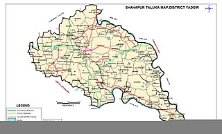
Shahapur is a city and taluka headquarter located in the Yadgir district of Indian state of Karnataka. Shahapur is 597 km north of Bangalore and well connected by road to Gulbarga (70 km), Hyderabad (240 km), Bidar (160 km), Raichur (90 km) and Yadgir (32 km).

Bidar district is the northernmost part of the Karnataka state in India. The administrative headquarters of district is Bidar city. Geographically, it resembles the "Crown of the State", occupying its northeastern end. It is bounded by Kamareddy and Sangareddy districts of Telangana state on the eastern side, Latur and Osmanabad districts of Maharashtra state on the western side, Nanded district of Maharashtra state on the northern side and Kalaburagi district on the southern side.

Kalaburagi district, formerly known as Gulbarga district, is one of the 31 districts of Karnataka state in southern India. Kalaburagi city is the administrative headquarters of the district. The district is the headquarters of Kalaburagi division.
Yadgiri is a city and the administrative headquarters of Yadgir district in the Indian state of Karnataka. It is also the administrative headquarters of Yadgir Taluka, one of the six taluks of Yadgir.
Bhalki is a town in Bidar district in the Indian state of Karnataka.It is 30 km from Bidar.It is the headquarters of Bhalki taluka panchayat.It is well connected by roadways and railways The karanja river one of the main river of Bidar district flows through bhalki taluka.
Chitagoppa is a taluka and town in Bidar district of Karnataka. Up until 2017, the city was under the administration of Humnabad. Chitguppa is divided into 23 wards. It is 15 kilometres (9.3 mi) from Humnabad and 53 kilometres (33 mi) from Bidar. The city is known for having the largest marketplace in the Bidar district and its corn production.It shares border with Kalaburagi district.The nearest highway is NH-65 which passes through Chitguppa taluk.
Koratagere is a Panchayat Town in Tumkur district in the Indian state of Karnataka.
Molakalmuru is a taluk in Chitradurga district in the Indian state of Karnataka. It is near the border of Karnataka and Andhra Pradesh. It borders the Rayadurg taluk of Ananthpur district of Andhra Pradesh. Legend has it that its name means "broken knees" in Kannada, referencing a battle between the native Indians and the British in which, due to the rocky and hilly terrain, British soldiers suffered many broken knees in their defeat. The town is famous for the unique Molkalmuru sarees manufactured here.
Nitte is a village in Karkala Taluk, Udupi District, Karnataka, India. It is located on the way from Padubidri to Karkala, about 26 kilometres southeast of the district capital Udupi, and 7 kilometres southwest of the taluka capital Karkala. In the year 2011, the village is home to 12,354 inhabitants.

Koppa is a panchayat town in Chikkamagaluru district in the Indian state of Karnataka. It is the headquarters of Koppa sub-district. The name "Koppa" is derived from the Kopada Veerabadra Swamy Temple, a historic site that attracts devotees from the Malnad region.
Joida is a town located in the Uttara Kannada district in the Indian state of Karnataka. The town is the headquarters of the eponymous taluk. Earlier it was known as Supa taluka but as Supa village got submerged due to dam built across river Kali, Joida taluka came into existence. Joida town has a Post office, branch of nationalised banks and a Police station.

Narayanapur is a village situated 3 kilometres away from Basavakalyan taluk of Bidar district in the Indian state of Karnataka.
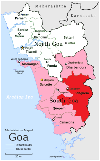
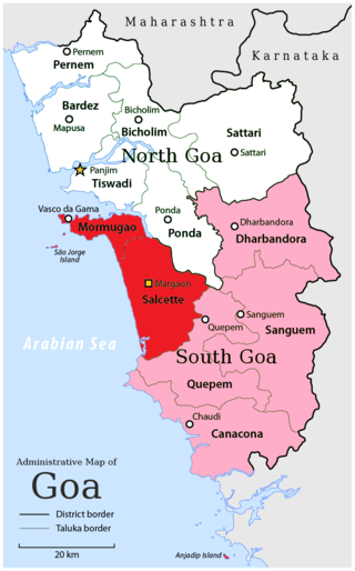
Sanguemtaluka is an administrative region of Goa state, India.

Pondataluka is a subdivision of the district of north Goa, in the Indian state of Goa. Its administrative headquarters is the township of Ponda.
Naigaon is a town and taluka in Nanded district of Maharashtra state in India. Naigaon (Bz.) is located 41.2 km south of the district headquarters city of Nanded and 60 km west from neighboring city of Nizamabad in Telangana State. Naigaon lies on MSH - 6. It is approximately 600 km from the State capital Mumbai. It is the Center of Naigaon Taluka. Naigaon is one of the rapidly growing towns in the Nanded District. The economy is primarily based on agriculture and related business.
Jat is a town and taluka headquarters in Miraj subdivision of Sangli district in southern Maharashtra.
Bantwal taluk is a taluk of Dakshina Kannada district. The headquarters is the town of Bantwal, an eastern suburb of Mangalore.
Aurad Shahajani is a Town located in the Nilanga Taluka of Latur District It's 20 kilometres Away From the City Of Nilanga And 68 Kilometres Away From The City Of Bidar And It's Situated In Maharashtra And Karnataka Border
Hebbal is a village in Khanapur taluka of Belgavi district, Karnataka, India. Its village code is 597576.


