
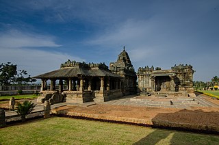
Hoysala architecture is the building style in Hindu temple architecture developed under the rule of the Hoysala Empire between the 11th and 14th centuries, in the region known today as Karnataka, a state of India. Hoysala influence was at its peak in the 13th century, when it dominated the Southern Deccan Plateau region. Large and small temples built during this era remain as examples of the Hoysala architectural style, including the Chennakesava Temple at Belur, the Hoysaleswara Temple at Halebidu, and the Kesava Temple at Somanathapura. Other examples of Hoysala craftsmanship are the temples at Belavadi, Amruthapura, Hosaholalu, Mosale, Arasikere, Basaralu, Kikkeri and Nuggehalli. Study of the Hoysala architectural style has revealed a negligible Indo-Aryan influence while the impact of Southern Indian style is more distinct.

Haveri is a district in the state of Karnataka, India with the potential to become a tourist hub. As of 2011, it had a population of 1,597,668 of which 20.78% were urban residents.

Bagalkot district, is an administrative district in the Indian state of Karnataka. The district headquarters is located in the town of Bagalkot. The district is located in northern Karnataka and borders Belgaum, Gadag, Koppal, Raichur and Bijapur. The new Bagalkot district was carved out of Bijapur in 1997 via Government of Karnataka directive Notification RD 42 LRD 87 Part III. The bifurcated Bagalkot district consists of nine taluks — Badami, Bagalkot, Bilagi, Guledgudda, Rabkavi Banhatti, Hunagund, Ilkal, Jamakhandi and Mudhol.

Gulbarga district, officially known as Kalaburagi district, is one of the 30 districts of Karnataka state in southern India. Gulbarga city is the administrative headquarters of the district. The district is the headquarters of Gulbarga division.
Gadag District is a district in the state of Karnataka, India. It was formed in 1997, when it was split from Dharwad District. As of 2011, it had a population of 1064570. The overall population increased by 13.14 percent from 1991 to 2001. Gadag District borders Bagalkot District on the north, Koppal District on the east, Bellary District on the southeast, Haveri District on the southwest, Dharwad District on the west and Belgaum District on the northwest. It features monuments from the Western Chalukya Empire. It has seven talukas/ tehsils: Gadag, Gajendragad,, Ron, Shirhatti, Nargund, Lakshmeshwar and Mundargi.

North Karnataka is a geographical region in Deccan plateau from 300 to 730 metres elevation that constitutes the northern part of the Karnataka state in India. It is drained by the Krishna River and its tributaries the Bhima, Ghataprabha, Malaprabha, and Tungabhadra. North Karnataka lies within the Deccan thorn scrub forests ecoregion, which extends north into eastern Maharashtra. Most parts of the region has black fertile soil ideal for agriculture.

Annigeri is a taluk of Dharwad district in the state of Karnataka, India, located 20 km west of Gadag en route to Hubli and 35 km from Hubli.
Basavakalyan or Basavakalyana is a City and taluka in Bidar District, Karnataka, India. and was historically known as Kalyan and Basavakalyan is the Second Largest Municipality City in Bidar District.

Gadag-Betageri is a city municipal council in Gadag district in the state of Karnataka, India. It is the administrative headquarters of Gadag District. The original city of Gadag and its sister city Betageri have a combined city administration. The municipality of Gadag-Betageri has a population of 172,813 and an area of 54.0956 km2 (20.8864 sq mi). Kanaginahal of Gadag is the birthplace of the first co-operative society in Asia. The temples of Veera Narayana and Trikuteshwara are places of religious and historic importance.

Dravidian architecture or the South Indian temple style is an architectural idiom in Hindu temple architecture that emerged in the southern part of the Indian subcontinent or South India and in Sri Lanka, reaching its final form by the sixteenth century. It is seen in Hindu temples, and the most distinctive difference from north Indian styles is the use of a shorter and more pyramidal tower over the garbhagriha or sanctuary called a vimana, where the north has taller towers, usually bending inwards as they rise, called shikharas. However, for modern visitors to larger temples the dominating feature is the high gopura or gatehouse at the edge of the compound; large temples have several, dwarfing the vimana; these are a much more recent development. There are numerous other distinct features.
Karnataka, the sixth largest state in India, has been ranked as the third most popular state in the country for tourism in 2014. It is home to 507 of the 3600 centrally protected monuments in India, the largest number after Uttar Pradesh. The State Directorate of Archaeology and Museums protects an additional 752 monuments and another 25,000 monuments are yet to receive protection. Tourism centres on the ancient sculptured temples, modern cities, the hill ranges, forests and beaches. Broadly, tourism in Karnataka can be divided into four geographical regions: North Karnataka, the Hill Stations, Coastal Karnataka and South Karnataka.
Balligavi a town in Shikaripura taluk Shivamogga district of Karnataka state, India, is today known as Belagami or Balagame. Its ancient names are Baligrama, Dakshina Kedara, Valliggame and Valligrame. Dakshina Kedara means Kedarnath of the South. A place of antiquity, it is known for its ancient monuments. Balligavi is located 72 km from Shivamogga city and 21 km from Shikaripura town and 2.3 km from Shiralakoppa in Shikaripura taluk. Balli in Kannada means creeper or vine.

Sudi, is a panchayat town in the Gadag District of Karnataka, India. It is about 30 km from Badami, 12 km from Gajendragad and 3 km from Itagi Bhimambika temple. In the past it was an important town of the Kalyani Chalukyas during 1000 AD. It is notable for rare stone carved monuments like Twin towered temple, Mallikarjuna temple and nagakunda , and few other structural temples. For long time these structures were abandoned, but recently they caught the eye of the Indian Archaeological Department.

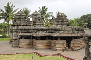
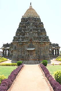
Western Chalukya architecture, also known as Kalyani Chalukya or Later Chalukya architecture, is the distinctive style of ornamented architecture that evolved during the rule of the Western Chalukya Empire in the Tungabhadra region of modern central Karnataka, India, during the 11th and 12th centuries. Western Chalukyan political influence was at its peak in the Deccan Plateau during this period. The centre of cultural and temple-building activity lay in the Tungabhadra region, where large medieval workshops built numerous monuments. These monuments, regional variants of pre-existing dravida temples, form a climax to the wider regional temple architecture tradition called Vesara or Karnata dravida. Temples of all sizes built by the Chalukyan architects during this era remain today as examples of the architectural style.
The Mahadeva Temple is located in the town of Itagi in Yelburga Taluk, in the Koppal District of Karnataka state, India. It is about 7 km (4 mi) from Kuknur and 20 km (12 mi) from Lakkundi.

Malkheda, also known as Malkhed,) is a town in Karnataka, India. It is located on the banks of Kagina River in Sedam Taluk of Gulbarga district, around 40 km from Kalaburagi.

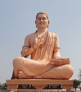
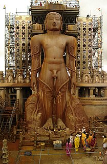
The antiquity of architecture of Karnataka can be traced to its southern Neolithic and early Iron Age, Having witnessed the architectural ideological and utilitarian transformation from shelter- ritual- religion. Here the nomenclature 'Architecture' is as old as c.2000 B.C.E. The upper or late Neolithic people in order to make their shelters, they constructed huts made of wattle and doab, that were buttressed by stone boulders, presumably having conical roof resting on the bamboo or wooden posts into red murram or paved granite chips as revealed in archaeological excavations in sites like Brhamagiri, Sanganakallu, Tekkalakota, Piklihal. Megaliths are the dominant archaeological evidence of the early Iron Age. There are more than 2000 early Iron Age burial sites on record, who laid the foundation for a high non-perishable architecture in the form of various distinct architectural styles of stone built burials, which are ritualistic in its character. The active religious architecture is evident 345 with that of the Kadamba Dynasty. Karnataka is a state in the southern part of India originally known as the State of Mysore. Over the centuries, architectural monuments within the region displayed a diversity of influences, often relaying much about the artistic trends of the rulers of twelve different dynasties. Its architecture ranges dramatically from majestic monolith, such as the Gomateshwara, to Hindu and Jain places of worship, ruins of ancient cities, mausoleums and palaces of different architectural hue. Mysore Kingdom (Wodeyar) rule has also given an architectural master structure in the St. Philomena's Church at Mysore which was completed in 1956, in addition to many Dravidian style architectural temples. Two of the monuments are listed under the UNESCO World Heritage List of 22 cultural monuments in India. Styles of Indo-Saracenic, Renaissance, Corinthian, Hindu, Indo-Greek and Indo-British style palaces were built in Mysore, the city of palaces. Sikh architecture at Bidar (1512) and also in Bangalore in 1956 can also be cited as having an impact on the architectural composition of the state.
Bidar is a historic place located in the north-eastern part of the South Indian state of Karnataka. Bidar enjoys a picturesque situation, having been situated and built on the brink of a plateau, and thus commanding lovely views of the lowlands (talghat) towards the north and the east. Its latitude is 17°55'N., its longitude 77°32' E., and the height above the sea-level 2,330 feet (710 m). The climate is bracing and the temperature in the hottest season does not usually rise above 105 °F (41 °C). The Bidar plateau is an irregular oblong, 22 miles (35 km) in length and 12 miles (19 km) in extreme breadth.

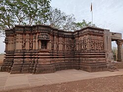
Iswara temple also known by other names Kamalishwara temple, Kamaleshwara temple, Kalleshwara temple, Eshwara temple is located in Jalasangvi village, about 10 km north-west of Humnabad Taluk of Bidar district, Karnataka, India. According to the inscriptions found the temple was built during the reign of the celebrated emperor Vikramaditya VI of Kalyana Chalukya dynasty.
