
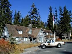
The Rising Sun Auto Camp, also known as the Roes Creek Auto Camp, East Glacier Auto Camp or simply Rising Sun preserves a portion of the built-up area of Glacier National Park that documents the second phase of tourist development in the park. Rising Sun is located along the Going-to-the-Sun Road, approximately 7 miles (11 km) from the east entrance to Glacier National Park, Montana, United States. Rising Sun is a wayside area that has a National Park Service campground, a camp store and gift shop, picnic area, restaurant, as well as a motel and guest cabins which are managed by the park's concessionaire, Xanterra Parks & Resorts. In the immediate area, there is also a boat dock as well as sightseeing boats which allow visitors to tour Saint Mary Lake, the second largest lake in the park. "The most popular spot for [Glacier] tourists is Rising Sun, an overlook of Goose Island in St. Mary Lake and one of the most photographed spots in the park."
Babb is a small unincorporated farming and ranching community in Glacier County, Montana, United States, on the Blackfeet Indian Reservation. The community experiences a large influx of tourists in the summer months as it is the gateway to the Many Glacier area of Glacier National Park. For statistical purposes, the United States Census Bureau has defined Babb as a census-designated place (CDP). It had a population of 174 at the 2010 census.

Grand Canyon Village Historic District comprises the historic center of Grand Canyon Village, on the South Rim of the Grand Canyon in Grand Canyon National Park, Arizona. The district includes numerous landmark park structures, many of which are National Historic Landmarks themselves, or are listed on the National Register of Historic Places. The town design as a whole is also significant for its attention to integration with the Grand Canyon landscape, its incorporation of National Park Service Rustic design elements, and for the idiosyncratic design of park concessioner structures such as the El Tovar Hotel.
Munson Valley Historic District is the headquarters and main support area for Crater Lake National Park in southern Oregon. The National Park Service chose Munson Valley for the park headquarters because of its central location within the park. Because of the unique rustic architecture of the Munson Valley buildings and the surrounding park landscape, the area was listed as a historic district on the National Register of Historic Places (NRHP) in 1988. The district has eighteen contributing buildings, including the Crater Lake Superintendent's Residence which is a U.S. National Historic Landmark and separately listed on the NRHP. The district's NRHP listing was decreased in area in 1997.

The Clackamas Lake Ranger Station Historic District is a Forest Service compound consisting of eleven historic buildings located in the Mount Hood National Forest in the Cascade Mountains of northern Oregon. It was originally built as a district ranger station for the Clackamas Lake Ranger District. It was later converted to a summer guard station. Today, the Forest Service rents the historic ranger's residence to recreational visitors. The Clackamas Lake Ranger Station is listed as a historic district on the National Register of Historic Places.
The Headquarters Historic District of Glacier National Park comprises the administrative and housing buildings near West Glacier, Montana on the west side of the park. The area contains a mixture of styles, ranging from National Park Service Rustic to more modern structures built immediately after World War II.

The Upper Lake McDonald Ranger Station in Glacier National Park was a formerly isolated site that became an administrative center with the opening of the Going-to-the-Sun Road. The National Park Service Rustic cabin was typical of the preferred style for western park structures of the period. The ranger station is similar to its counterparts at Belly River and Sherburne, as well as the Polebridge Ranger Station residence.

The Polebridge Ranger Station in Glacier National Park was the first administrative area in the park, predating the park's establishment. The ranger station was destroyed by fire, leaving the residence.
The East Glacier Ranger Station, east of Glacier National Park, is characteristic of park buildings constructed in the 1920s and 1930s. It was designed by Daniel Ray Hull of the National Park Service Office of Plans, as a frame building compatible in style with the prevailing National Park Service Rustic style. It is the center of a group of related buildings, including several residential structures.

The Cut Bank Ranger Station in Glacier National Park was one of the first buildings built in Glacier by the National Park Service. Built in 1917, the design is in keeping with park hotel structures built by the Great Northern Railway in a Swiss chalet style that predated the fully developed National Park Service Rustic style.

The Logan Pass Visitor Center in Glacier National Park was constructed at the summit of the Going-to-the-Sun Road during the Mission 66 park facilities improvement program. The design concept was originated by architect Cecil J. Doty of the National Park Service Western Office of Design and Construction. Burt L. Gewalt of the Kalispell, Montana architectural firm Brinkman and Lenon was responsible for the construction documents, carried out between 1960 and 1962. Construction was completed in 1966. The visitor center uses common Mission 66 themes such as a broad, gently sloping roof, native stone, and glulam timber construction.

The Saint Mary Visitor Center in Glacier National Park, with the connected Saint Mary Checking Station and Entrance Station was constructed at the east entrance to the Going-to-the-Sun Road during the Mission 66 park facilities improvement program. It was designed by Burt L. Gewalt of the Kalispell, Montana architectural firm Brinkman and Lenon, and was completed in 1967. The complex uses common Mission 66 themes such as native stone, and glulam timber construction, combined with a dramatic roof structure that echoes the mountain peaks in the background. The stone in the walls came from the Going-to-the-Sun Road. The view of the "St. Mary" webcam on the Glacier National Park official website is broadcast from the center and shows the westward-facing view over St. Mary Lake, which includes a distant view of Logan's Pass. There is also an osprey nest about one hundred meters to the east of the building, which can be viewed from the visitor parking lot and from the park's osprey webcam.

The Swiftcurrent Auto Camp Historic District preserves a portion of the built-up area of Glacier National Park that documents the second phase of tourist development in the park. After the creation of a series of hotels for train-borne visitors including the nearby Many Glacier Hotel, courtesy of the Great Northern Railway's hotel concession, facilities were developed for the increasing numbers of automobile-borne tourists, drawn to Glacier by the Going-to-the-Sun Road. The Swiftcurrent Auto Camp at Swiftcurrent Lake was created for these new tourists. It includes a rustic general store, built in 1935 by the Glacier Park Hotel Company, surrounded by a number of log tourist cabins., as well as a shower and laundry house and other supporting structures.

The Belly River Ranger Station Historic District in Glacier National Park includes several historic structures, including the original ranger station, now used as a barn. The rustic log structures were built beginning in 1912. Other buildings include a woodshed, built in 1927 to standard National Park Service plans and a cabin used as a fire cache.

The Grand Canyon North Rim Headquarters is a historic district on the North Rim of the Grand Canyon in Grand Canyon National Park, Arizona. Established from 1926 through the 1930s, the district includes examples of rustic architecture as applied to employee residences, administrative facilities and service structures.

The Fall River Entrance Historic District in Rocky Mountain National Park preserves an area of park administration buildings and employee residences built in the National Park Service Rustic style. The area is close to Estes Park, Colorado, at the original primary entrance to the east side of the park. The area includes the Bighorn Ranger Station, several houses, and some utility buildings. The buildings were designed in the 1920s and 1930s by the National Park Service Branch of Plans and Designs. Many of the 1930s buildings were built by Civilian Conservation Corps labor.
The Zigzag Ranger Station is a Forest Service compound consisting of twenty rustic buildings located in Oregon's Mount Hood National Forest. It was built as the administrative headquarters for the Zigzag Ranger District. It is located in the small unincorporated community of Zigzag, Oregon. Many of the historic buildings were constructed by the Civilian Conservation Corps between 1933 and 1942. Today, the Forest Service still uses the ranger station as the Zigzag Ranger District headquarters. The ranger station is listed on the National Register of Historic Places.

The Lake McDonald Lodge Coffee Shop is a visitor services building in the Lake McDonald district of Glacier National Park, Montana, USA. The coffee shop was built in 1965 as part of the National Park Service's Mission 66 program to upgrade visitor facilities, in order to increase visitor dining capacity. Under the Mission 66 projects, visitor facilities were usually comprehensive in nature, providing a range of visitor services. Specialized concession buildings like the Coffee Shop were unusual in Mission 66. It was leased to the Glacier Park Company for operation, in anticipation of the construction of lodging facilities by the company.
Architects of the National Park Service are the architects and landscape architects who were employed by the National Park Service (NPS) starting in 1918 to design buildings, structures, roads, trails and other features in the United States National Parks. Many of their works are listed on the National Register of Historic Places, and a number have also been designated as National Historic Landmarks.

The Saint Mary Ranger Station is a ranger station in Glacier National Park in the U.S. state of Montana. The log cabin was built in 1913 on the east side of the park overlooking Upper Saint Mary Lake. The oldest administrative structures in the park., it features an architecture that foreshadows the National Park Service Rustic style.


