
Skyline Drive is a 105-mile (169 km) National Parkway that runs the entire length of the National Park Service's Shenandoah National Park in the Blue Ridge Mountains of Virginia, generally along the ridge of the mountains. The drive's northern terminus is at an intersection with U.S. Route 340 (US 340) near Front Royal, and the southern terminus is at an interchange with US 250 near Interstate 64 (I-64) in Rockfish Gap, where the road continues south as the Blue Ridge Parkway. The road has intermediate interchanges with US 211 in Thornton Gap and US 33 in Swift Run Gap. Skyline Drive is part of Virginia State Route 48, which also includes the Virginia portion of the Blue Ridge Parkway, but this designation is not signed.

Park Ridge is an active commuter railroad station in the borough of Park Ridge, Bergen County, New Jersey. Located at the intersection of Park and Hawthorne Avenues, the station services trains on the Pascack Valley Line, which runs from Hoboken Terminal to Spring Valley station in New York. The station contains a single low-level side platform split by Park Avenue and a wooden station depot, built by the Hackensack and New York Extension Railroad. As a result, Park Ridge station is not handicap accessible under the Americans with Disabilities Act of 1990.

Bowman Lake is in the northwestern portion of Glacier National Park in Montana. The lake is accessed via a 6 miles (9.7 km) unpaved road from the small town of Polebridge. At 1,706 acres (690 ha), Bowman Lake is the third largest lake in the park, after Lake McDonald and Saint Mary Lake.

The North Entrance Road Historic District comprises Yellowstone National Park's North Entrance Road from Gardiner, Montana to the park headquarters at Mammoth Hot Springs, Wyoming, a distance of a little over five miles (8 km). The North Entrance Road was the first major road in the park, necessary to join the U.S. Army station at Fort Yellowstone to the Northern Pacific Railroad station at Gardiner. The road includes the Roosevelt Arch at the northern boundary of the park and winds through rolling terrain before crossing the Gardner River and joining the Grand Loop Road.

The Jackson Lake Ranger Station is the last Depression-era U.S. Forest Service ranger station in its original location in Grand Teton National Park. When first established, the park comprised only the mountainous terrain above Jackson Hole, while the remainder of what would eventually become the park was administered by the Forest Service as part of Teton National Forest. The Jackson Lake Station was built in 1933 as close as possible to Park Service property as possible as a kind of resistance to the park's expansion. The station was one of five Forest Service stations in the area, and was taken over by the National Park Service when Jackson Hole National Monument was established in 1943, later becoming an enlarged Grand Teton National Park. It is the only such station not to have been moved or altered by the Park Service.

The Jenny Lake Ranger Station Historic District comprises an area that was the main point of visitor contact in Grand Teton National Park from the 1930s to 1960. Located near Jenny Lake, the buildings are a mixture of purpose-built structures and existing buildings that were adapted for use by the National Park Service. The ranger station was built as a cabin by Lee Mangus north of Moose, Wyoming about 1925 and was moved and rebuilt around 1930 for Park Service use. A store was built by a concessioner, and comfort stations were built to Park Service standard plans. All buildings were planned to the prevailing National Park Service Rustic style, although the ranger station and the photo shop were built from parts of buildings located elsewhere in the park.

The Upper Lake McDonald Ranger Station in Glacier National Park was a formerly isolated site that became an administrative center with the opening of the Going-to-the-Sun Road. The National Park Service Rustic cabin was typical of the preferred style for western park structures of the period. The ranger station is similar to its counterparts at Belly River and Sherburne, as well as the Polebridge Ranger Station residence.

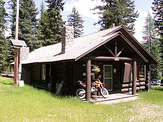
The Polebridge Ranger Station in Glacier National Park was the first administrative area in the park, predating the park's establishment. The ranger station was destroyed by fire, leaving the residence.

The Sherburne Ranger Station in Glacier National Park is an example of the National Park Service Rustic style. Located in the Swiftcurrent portion of the park, it was built in 1926. It is part of a small historic district that includes a mess hall and subsidiary structures, formerly known as the Sherburne Road Camp, established in 1931. The ranger station closely resembles the ranger stations at Belly River and Lake McDonald. A checking station at the road remains substantially intact.

The Belly River Ranger Station Historic District in Glacier National Park includes several historic structures, including the original ranger station, now used as a barn. The rustic log structures were built beginning in 1912. Other buildings include a woodshed, built in 1927 to standard National Park Service plans and a cabin used as a fire cache.

The Kintla Lake Ranger Station in Glacier National Park is a rustic log structure that was built by the Butte Oil Company in 1900 at Kintla Lake. It was taken over by the National Park Service and used as a ranger station. It is significant as a remnant of early oil exploration activities in the Glacier area. A boathouse was built by the National Park Service in 1935 to the same design as the boathouses at Upper Lake McDonald and Saint Mary ranger stations. A fire cache cabin, identical to those at Logging Creek, Polebridge and Lake McDonald ranger stations was built in 1934.
The Skyland Camp-Bowman Lake Ranger Station in Glacier National Park was originally built as the Culver Boys' Military Academy. The main building, known variously as the Skyland Camp Messhall, Culver Boys' Military Academy Messhall and Skyline Chalet, was built in 1920 and is a good example of National Park Service Rustic architecture. The main cabin, known as "Rainbow Lodge" was built by the boys of the academy in 1920 from red cedar logs, and is more elaborate and carefully detailed than typical ranger stations of this period. The interior is dominated by a stone fireplace.

The Numa Ridge Fire Lookout in Glacier National Park is significant as one of a chain of staffed fire lookout posts within the park. The low two-story timber-construction structure with a pyramidal roof was built in 1933. The lookout was built to a standard plan originated by the U.S. Forest Service as part of a program to provide overlapping fire lookout coverage within the park.

The Bowman Lake Patrol Cabin in Glacier National Park, Montana, United States, is a rustic back-country log cabin. Built in 1934, the cabin has a single room, with a front porch extension to create a shelter from snowfall.

The Fall River Pass Ranger Station in Rocky Mountain National Park was designed by National Park Service landscape architect Daniel Ray Hull in the National Park Service Rustic style. Built in 1922, the stone structure is similar in design to the Chasm Lake Shelter. Between 1933 and 1937 the ranger station was converted to a museum. The ranger station is associated with the construction of the nearby Trail Ridge Road. Located above the tree line, the building has a trap door in the roof to allow access when the door is blocked by drifting snow.

The following articles relate to the history, geography, geology, flora, fauna, structures and recreation in Glacier National Park (U.S.), the U.S. portion of the Waterton-Glacier International Peace Park.

The historical buildings and structures of Grand Teton National Park include a variety of buildings and built remains that pre-date the establishment of Grand Teton National Park, together with facilities built by the National Park Service to serve park visitors. Many of these places and structures have been placed on the National Register of Historic Places. The pre-Park Service structures include homestead cabins from the earliest settlement of Jackson Hole, working ranches that once covered the valley floor, and dude ranches or guest ranches that catered to the tourist trade that grew up in the 1920s and 1930s, before the park was expanded to encompass nearly all of Jackson Hole. Many of these were incorporated into the park to serve as Park Service personnel housing, or were razed to restore the landscape to a natural appearance. Others continued to function as inholdings under a life estate in which their former owners could continue to use and occupy the property until their death. Other buildings, built in the mountains after the initial establishment of the park in 1929, or in the valley after the park was expanded in 1950, were built by the Park Service to serve park visitors, frequently employing the National Park Service Rustic style of design.
Architects of the National Park Service are the architects and landscape architects who were employed by the National Park Service (NPS) starting in 1918 to design buildings, structures, roads, trails and other features in the United States National Parks. Many of their works are listed on the National Register of Historic Places, and a number have also been designated as National Historic Landmarks.

The Los Burros Ranger Station is a forest ranger station situated in Apache County, Arizona. The station was staffed by rangers who traveled to the nearby Lake Mountain Lookout.

The Bowman Lake Road was listed on the National Register of Historic Places in 1996. It was deemed significant " for its association with federal development of the North Fork region.... The site's period of significance extends from construction in 1914, when park officials began concerted efforts to develop the Bowman Lake area as part of its fire-control and recreation-development programs, until the end of the historic period as defined by the National Register (1945)."


