St Matthew's, Preston

Last updated

St Matthew’s
Electoral ward of St Matthews in Preston.png
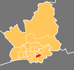
Location in the City of Preston district
Location map United Kingdom Preston 2012.svg
Red pog.svg
St Matthew’s
Location in Preston
Lancashire UK location map.svg
Red pog.svg
St Matthew’s
Location within Lancashire
Population8,187 (2011)
District
Ceremonial county
Region
Country England
Sovereign state United Kingdom
UK Parliament
Councillors
  • Javed Iqbal – Labour
  • Albert Richardson – Labour
  • Veronica Afrin – Labour
List of places
UK
England
Lancashire
53°46′05″N2°40′44″W / 53.768°N 2.679°W / 53.768; -2.679 Coordinates: 53°46′05″N2°40′44″W / 53.768°N 2.679°W / 53.768; -2.679

St Matthew's is an electoral ward in Preston, Lancashire, England. The ward is adjacent to the larger Ribbleton to the east but is considered to be an area with a distinct community of its own.

Contents

The ward is named after the large St Matthew's Church within its borders. Three members of Preston City Council, elected 'in thirds' in first past the post elections each year, are returned from the ward.

The ward forms part of the Lancashire County Council electoral division of Preston East.

Demographics

The 2001 census showed a population of 6,462 within St Matthew's, of which over half (58%) classed themselves as Christian. The next highest religious population is Muslim at just under 17%. The population at the 2011 Census was 8,187. [1]

Nearly half of the adult population have no education qualifications, one of the highest figures in the city of Preston.

Boundaries

St Matthew's is a rectangle sized ward with the city centre and Deepdale at one side, Fishwick to the south, and Ribbleton to the east. Preston Prison is at the south-west of the ward, which is otherwise populated by terraced housing and shopping units and warehouses. A number of Preston Bus and Stagecoach services run across the ward towards Ribbleton, Longridge and beyond.

Current members

ElectionMemberParty
2007 Preston Council election Javed IqbalLabour Party
2008 Preston Council election Veronica AfrinLabour Party
2014 Preston City Council election Roy LeemingLabour Party

Demographics

From the 2001 census, [2] St George's ward had a population of 5,049. Of this figure, 26.7% described themselves as Muslim.

See also

Related Research Articles

Moor Park, Preston Human settlement in England

Moor Park is a large park to the north of the city centre of Preston, Lancashire, England. Moor Park is also the name of the electoral ward covering the park and the surrounding area. The ward borders the traditional boundary of Fulwood. The population of the ward as at the 2011 census was 5,211.

Fulwood, Lancashire Human settlement in England

Fulwood is an area and unparished area in Lancashire, England, forming much of the northern half of the unparished part of the City of Preston district. It had a population of 28,535 in 2011 and is made up of five wards.

2006 Preston City Council election

The City Council elections for the City of Preston, Lancashire were held on 4 May 2006 on the same day as other 2006 United Kingdom local elections. Nineteen electoral wards were fought. The only change was that Labour gained one seat from the Liberal Democrats, continuing to be the largest party, but the Council remained under no overall control

2007 Preston City Council election

Elections to the Preston City Council took place on 3 May 2007.

Cadley, Lancashire Human settlement in England

Cadley is a largely residential suburban area of Preston, Lancashire, England, and an electoral ward. The population of the ward taken at the 2011 census was 4,589. It is usually considered to be a district of the larger suburb of Fulwood, but was historically separate as evidenced, for instance, in the name of Fulwood and Cadley County Primary School.

Ashton-on-Ribble Human settlement in England

Ashton-on-Ribble is a suburb of Preston, Lancashire, England. The population of the Ashton Ward taken at the 2011 census was 4,459.

Ribbleton Human settlement in England

Ribbleton is a suburb and ward of the city of Preston, Lancashire, England. It is located to the east of the city centre, between the A59 New Hall Lane and the B6243 Longridge Road. The M6 motorway also runs through the area. The ward had a population of 7,351 recorded in the 2001 census increasing to 8,548 at the 2011 Census.

Brookfield, Preston Human settlement in England

Brookfield is an electoral ward of the city of Preston, in Lancashire, England. It is located north-east of the city centre, in the suburb of Ribbleton. At the 2001 census the ward had a population of 7,625, reducing to 7,301 at the 2011 Census. The area is represented on the city council by three Labour councillors. The area forms part of the Preston East division of Lancashire County Council, represented by one Labour councillor.

Preston is a city of Lancashire, England. The districts of Preston vary in size and shape, many of which reflect the districts developed from former villages and boroughs which now lie within the boundaries of the city of Preston. Districts of Preston have little administrative purpose: for local elections voters in each return either two, or three, councillors to Town Hall. For the purposes of national General elections, the parliamentary constituencies representing the city use the electoral districts as "building bricks"

Riversway Human settlement in England

Riversway is an electoral ward in Preston, Lancashire, England. The ward is named for its location close to the River Ribble, and the historical links to the former Port of Preston. The ward can be split into three distinct areas; the former Docklands, now a shopping area and residential community, with new build apartments and housing overlooking the dock; Broadgate, the residential area built during the Industrial Revolution; and Christ Church, a community of traditional terraced housing.

Deepdale, Preston Human settlement in England

Deepdale is an electoral ward in Preston, Lancashire, England. The population of the ward as taken at the 2011 census was 6,103. The ward is home to the Deepdale football stadium of Preston North End. The ward is a predominantly urban area of terraced housing, notable for one of the largest South Asian populations in the city.

Preston Rural North Human settlement in England

Preston Rural North is an electoral ward in the City of Preston, Lancashire, England. The ward is the largest by area in the city, containing the smaller and smallest villages from the northern areas of Preston, from Woodplumpton bordering the M55 motorway junction at Broughton, to Beacon Fell at the border of the borough of Wyre.

Ingol Human settlement in England

Ingol is an electoral ward and suburb of Preston, Lancashire, England. The population of the Ward as taken at the 2011 census was 7,369. The ward also includes the district of Tanterton. The ward is coterminous with the civil parish of Ingol and Tanterton, created in 2012.

Preston Rural East Human settlement in England

Preston Rural East is an electoral ward in the City of Preston, Lancashire, England. The ward is in the eastern and northeastern part of the city near the M55 motorway moving out towards Sherwood and Grimsargh. The population of the ward at the 2011 census was 4,577.

Greyfriars, Preston Human settlement in England

Greyfriars is a largely residential suburban area of Preston, Lancashire, England, and an electoral ward. It is nowadays usually considered to be a district of the larger suburb of Fulwood, but was historically separate as evidenced, for instance, in the name of the private home from which the name is taken.

Sharoe Green Human settlement in England

Sharoe Green is a largely residential suburban area of Preston, Lancashire, England, and an electoral ward. It is nowadays usually considered to be a district of the larger suburb of Fulwood. Preston golf course is within the ward boundaries, and the Royal Preston Hospital, now the sole main provider of NHS hospital treatment in the city.

St Georges, Preston Human settlement in England

For the church of the same name, see Church of St George the Martyr, Preston.

College (Preston ward) Human settlement in England

College is an electoral ward and one of the districts of Preston. The population of the Ward as taken at the 2011 census was 3,578. College is in the Fulwood area in northern Preston, Lancashire, England. The ward is based in the Sharoe Green area with the name being derived from the central placement of Preston College.

City of Preston, Lancashire City & Non-metropolitan district in England

The City of Preston is a city and non-metropolitan district in Lancashire, England. On the north bank of the River Ribble, it was granted city status in 2002, becoming England's 50th city in the 50th year of Queen Elizabeth II's reign. The City of Preston district has a population of 143,135 (mid-2019 est.), and lies at the centre of the Central Lancashire sub-region, with a population of 335,000.

Elections to Preston City Council took place on 3 May 2012, the same day as other 2012 United Kingdom local elections.

References

  1. UK Census (2011). "Local Area Report – St Matthew's 2011 Census Ward (1237324289)". Nomis. Office for National Statistics . Retrieved 11 March 2018.
  2. Office for National Statistics