Brookfield, Preston

Last updated

Brookfield
Brookfieldinpreston.JPG
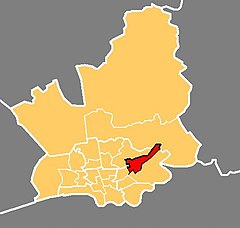
Location in the City of Preston district
Location map United Kingdom Preston 2012.svg
Red pog.svg
Brookfield
Location in Preston
Lancashire UK location map.svg
Red pog.svg
Brookfield
Location within Lancashire
Population7,301 (2011)
District
Ceremonial county
Region
Country England
Sovereign state United Kingdom
UK Parliament
  • Preston
Councillors
  • John Browne – Labour
  • Nerys Eaves – Labour
  • Philip Corker – Labour
List of places
UK
England
Lancashire
53°46′55″N2°39′58″W / 53.782°N 2.666°W / 53.782; -2.666 Coordinates: 53°46′55″N2°39′58″W / 53.782°N 2.666°W / 53.782; -2.666

Brookfield is an electoral ward of the city of Preston, in Lancashire, England. It is located north-east of the city centre, in the suburb of Ribbleton. At the 2001 census the ward had a population of 7,625, [1] reducing to 7,301 at the 2011 Census. [2] The area is represented on the city council by three Labour councillors. The area forms part of the Preston East division of Lancashire County Council, represented by one Labour councillor.

Contents

The area is mainly residential, and the majority of homes are privately owned although there is also a large council estate. The ward also contains a modern business park, which includes the head office of Booths, a regional chain of supermarkets. This is close to junction 31A on the M6 motorway.

Current members

ElectionMemberParty
2015 Preston City Council election Nerys EavesLabour Party
2013 Preston City Council election Philip CorkerLabour Party
2014 Preston City Council election John BrowneLabour Party

[3]

Transport

The M6 motorway runs through the area, but until recently there was no junction nearby. Junction 31A has now been built, but there is no connection to or from the Lancaster direction. [4] Ribbleton railway station was near the Ribbleton ward boundary but the line has now closed. Bus services are provided by Preston Bus.

Related Research Articles

Metropolitan Borough of Wigan Metropolitan borough in England

The Metropolitan Borough of Wigan is a metropolitan borough of Greater Manchester, in North West England. It is named after the main settlement of Wigan. It covers the towns of Atherton, Ashton-in-Makerfield, Golborne, Hindley, Ince-in-Makerfield, Leigh and Tyldesley. The borough also covers the villages and suburbs of Abram, Aspull, Astley, Bryn, Hindley Green, Lowton, Mosley Common, Orrell, Pemberton, Shevington, Standish, Winstanley and Worsley Mesnes.

Old Swan Human settlement in England

Old Swan is an eastern neighbourhood of Liverpool, Merseyside, England, bordered by Knotty Ash, Stoneycroft, Broadgreen, Fairfield and Wavertree. At the 2011 Census, the population was 16,461.

Civil parishes in Lancashire

A civil parish is a subnational entity, forming the lowest unit of local government in England. There are 219 civil parishes in the ceremonial county of Lancashire; Blackpool is completely unparished; Pendle and Ribble Valley are entirely parished. At the 2001 census, there were 587,074 people living in the 219 parishes, accounting for 41.5 per cent of the county's population.

Preston (UK Parliament constituency) Parliamentary constituency in the United Kingdom, 1983 onwards

Preston is a constituency represented in the House of Commons of the UK Parliament since 2000 by Sir Mark Hendrick, a member of the Labour Party and Co-operative Party.

Bamber Bridge Human settlement in England

Bamber Bridge is an urban village in Lancashire, England, 3 miles (5 km) south-east of Preston, in the borough of South Ribble. The name derives from the Old English "bēam" and "brycg", which probably means "tree-trunk bridge". The population was 13,945 at the 2011 Census.

Altham, Lancashire Human settlement in England

Altham is a village and civil parish in the Borough of Hyndburn, in Lancashire, England. It is the only parish in the borough – the remainder is an unparished area. The village is 4.3 miles (6.9 km) west of Burnley, 2.9 miles (4.7 km) north of Accrington, and 2 miles (3.2 km) north-east of Clayton-le-Moors, and is on the A678 Blackburn to Burnley road.

Preston City Council elections

One third of Preston City Council in Lancashire, England is elected each year, followed by one year without election to allow for the Lancashire County Council elections. Preston is a non-metropolitan district forming a lower-tier of local government under Lancashire County Council.

Fulwood, Lancashire Human settlement in England

Fulwood is an area and unparished area in Lancashire, England, forming much of the northern half of the unparished part of the City of Preston district. It had a population of 28,535 in 2011 and is made up of five wards.

2006 Preston City Council election

The City Council elections for the City of Preston, Lancashire were held on 4 May 2006 on the same day as other 2006 United Kingdom local elections. Nineteen electoral wards were fought. The only change was that Labour gained one seat from the Liberal Democrats, continuing to be the largest party, but the Council remained under no overall control

2007 Preston City Council election

Elections to the Preston City Council took place on 3 May 2007.

Cadley, Lancashire Human settlement in England

Cadley is a largely residential suburban area of Preston, Lancashire, England, and an electoral ward. The population of the ward taken at the 2011 census was 4,589. It is usually considered to be a district of the larger suburb of Fulwood, but was historically separate as evidenced, for instance, in the name of Fulwood and Cadley County Primary School.

Ribbleton Human settlement in England

Ribbleton is a suburb and ward of the city of Preston, Lancashire, England. It is located to the east of the city centre, between the A59 New Hall Lane and the B6243 Longridge Road. The M6 motorway also runs through the area. The ward had a population of 7,351 recorded in the 2001 census increasing to 8,548 at the 2011 Census.

Haighton Human settlement in England

Haighton is a civil parish in the City of Preston, Lancashire, England. It is a rural area north east of the urban city of Preston, beyond Fulwood and Brookfield.

Preston is a city of Lancashire, England. The districts of Preston vary in size and shape, many of which reflect the districts developed from former villages and boroughs which now lie within the boundaries of the city of Preston. Districts of Preston have little administrative purpose: for local elections voters in each return either two, or three, councillors to Town Hall. For the purposes of national General elections, the parliamentary constituencies representing the city use the electoral districts as "building bricks"

Preston Rural North Human settlement in England

Preston Rural North is an electoral ward in the City of Preston, Lancashire, England. The ward is the largest by area in the city, containing the smaller and smallest villages from the northern areas of Preston, from Woodplumpton bordering the M55 motorway junction at Broughton, to Beacon Fell at the border of the borough of Wyre.

St Matthews, Preston Human settlement in England

St Matthew’s is an electoral ward in Preston, Lancashire, England. The ward is adjacent to the larger Ribbleton to the east but is considered to be an area with a distinct community of its own.

Transport in Preston

Preston is a city in Lancashire, around 50 kilometres (31 mi) north-west of Manchester.

City of Preston, Lancashire City & Non-metropolitan district in England

The City of Preston is a city and non-metropolitan district in Lancashire, England. On the north bank of the River Ribble, it was granted city status in 2002, becoming England's 50th city in the 50th year of Queen Elizabeth II's reign. The City of Preston district has a population of 143,135 (mid-2019 est.), and lies at the centre of the Central Lancashire sub-region, with a population of 335,000.

2011 Preston City Council election

Elections to the Preston City Council took place on 5 May 2011, the same day as other 2011 United Kingdom local elections. This was also the date of the 2011 United Kingdom Alternative Vote referendum. At this election, The Labour Party regained majority control of the council.

Elections to Preston City Council took place on 3 May 2012, the same day as other 2012 United Kingdom local elections.

References

  1. "Archived copy" (PDF). Archived from the original (PDF) on 29 October 2007. Retrieved 7 November 2007.CS1 maint: archived copy as title (link)
  2. UK Census (2011). "Local Area Report – Brookfield 2011 Census Ward (1237324273)". Nomis. Office for National Statistics . Retrieved 10 March 2018.
  3. Preston City Council
  4. How to Find Us [ permanent dead link ]