Barton, Preston

Last updated

Barton
Parish Church of St Lawrence, Barton - geograph.org.uk - 410945.jpg
Saint Lawrence's church
Location map United Kingdom City of Preston.svg
Red pog.svg
Barton
Shown within the City of Preston district
Lancashire UK location map.svg
Red pog.svg
Barton
Location within Lancashire
Area3.81 sq mi (9.9 km2)  [1] 987.66 hectares
Population1,150 (2011)
  Density 302/sq mi (117/km2)
OS grid reference SD516373
Civil parish
  • Barton
District
Shire county
Region
Country England
Sovereign state United Kingdom
Post town PRESTON
Postcode district PR3
Dialling code 01772
Police Lancashire
Fire Lancashire
Ambulance North West
UK Parliament
List of places
UK
England
Lancashire
53°49′48″N2°44′06″W / 53.830°N 2.735°W / 53.830; -2.735

Barton is a linear village and civil parish in the City of Preston, Lancashire, England. The parish had a population of 1,150, of whom 552 were male and 598 were female, according to the 2011 census. [1]

Contents

Geography

The village is about 6 miles (10 km) north of Preston and 2 miles (3 km) north of Broughton. The parish is bound by the A6 road to the west. A bridge carries the A6 over the West Coast Main Line railway north of the village hall. The M6 motorway also passes through the parish, splitting the village, west of the motorway, from the rest of the parish.

Barton Brook flows north east to south west through the parish and is so named from the point where Sparling Brook joins Westfield Brook south of Barton Old Hall. [2] A marker for the parish boundary with Broughton is on the A6 at Cardwell Bridge over the brook. The bridge was rebuilt in 1921 after being damaged by floods. [3]

Barton Grange was built as the country residence for John Healey, a local mill owner and was later the home of Levi Collison MP. In 1940 it was requisitioned by the War Office and is now a hotel. [4]

Barton is named on the base of three milestones along the Garstang Road. One is now in Broughton after parish boundary changes. All three are listed by Historic England.

History

The parish church of St Lawrence was re-built in 1895 to a design by Richard Knill Freeman. [5] [6] It is a Grade II listed building. [7] It is part of the Fellside Team of parishes. [8]

The Boar's Head public house on the Garstang Road near St Lawrence's was part of village life for two hundred years. Its external appearance was described in 1872; rails at the front, little white stones all round bordered by bright flowers, "scrupulously clean" front steps with roses blooming above, and a "fierce yet faded representation of a wild animal's head, with savage tusks, and a tongue swinging beautifully to the left". [9] The public house closed in 2017, the building was severely damaged by a deliberately started fire two years later and demolished in 2022 to make way for a housing development. [10]

Barton and Broughton railway station at Newsham, ¾ mile to the south of Barton, opened in 1840 and closed to passenger traffic in 1939. [11]

Amenities

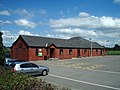
Barton St Lawrence CofE Primary School is on Jepps Avenue. The village hall on the northern edge of the village was built in 1924. [12] Barton Bowling Club and Barton and Myerscough Tennis Club each have facilities next to the hall.

Newsham

Newsham was added to Barton parish in 1894, it was previously in Goosnargh parish. [2] St Mary's Newhouse Catholic Church in Station Lane, Newsham was consecrated in 1906, the building replacing earlier ones. [13] St Mary & St Andrew's Catholic Primary School, previously known as Newhouse School, also on Station Lane, is a 1988 amalgamation on the existing site of St Mary's with St Andrew's, Cottam. The school buildings date from 1857. [14] A. Hewitson who wrote regular columns for the Preston Chronicle in the 1870s under the nom de plume Atticus failed to be stirred by the views from the catholic chapel, saying, "nothing very picturesque can be seen . . . ". [15]

Governance

Barton is within the City of Preston electoral ward of Preston Rural North, and the Preston Rural electoral division of Lancashire County Council. The civil parish of Barton was part of Preston Rural District throughout its existence from 1894 to 1974. [16] In 1974 the parish became part of the Borough of Preston, which became a city in 2002.

See also

Related Research Articles

<span class="mw-page-title-main">Bolton-le-Sands</span> Human settlement in England

Bolton-le-Sands is a large village and civil parish of the City of Lancaster in Lancashire, England. The parish had a population of 4,098 recorded in the 2001 census, increasing to 4,127 at the 2011 Census.

<span class="mw-page-title-main">Goosnargh</span> Village and parish in Lancashire, England

Goosnargh is a village and civil parish in the City of Preston district of Lancashire, England.

<span class="mw-page-title-main">Grimsargh</span> Human settlement in England

Grimsargh is a village and civil parish in the City of Preston, Lancashire, England. located 6 miles (10 km) east of Preston.

<span class="mw-page-title-main">Clayton-le-Woods</span> Human settlement in England

Clayton-le-Woods is a large village and civil parish of the Borough of Chorley, in Lancashire, England. According to the census of 2001, it has a population of 14,528. At the 2011 census the population of Cuerden civil parish was included within Clayton-le-Woods, giving a total of 14,532.

<span class="mw-page-title-main">Broughton, Lancashire</span> Human settlement in England

Broughton is a village and civil parish in the City of Preston, Lancashire, England, approximately 4 miles (6 km) north of Preston city centre. According to the 2001 census it had a population of 1,735, decreasing to 1,722 at the 2011 Census, increasing to 2,467 at the 2021. The parish is included in Preston Rural East ward of Preston city council, and the Preston Rural division of Lancashire County council.

<span class="mw-page-title-main">Pilling</span> Human settlement in England

Pilling is a village and civil parish within the Wyre borough of Lancashire, England. It is 6.5 miles (10.5 km) north-northeast of Poulton-le-Fylde, 9.4 miles (15.1 km) south-southwest of Lancaster and 14.5 miles (23.3 km) northwest of Preston, in a part of the Fylde known as Over Wyre.

<span class="mw-page-title-main">Claughton, Wyre</span> English village and parish also known as Claughton-on-Brock

Claughton is a sparse village and civil parish in the county of Lancashire in the north of England, in the Borough of Wyre. The population of the civil parish at the 2011 census was 633. It is sometimes called Claughton-on-Brock to distinguish it from another Claughton in Lancashire in the Lune valley between Lancaster and Hornby.

<span class="mw-page-title-main">Bonds, Lancashire</span> Village in England

Bonds is a village in Lancashire, England. It lies immediately south of Garstang town centre, on the opposite bank of the River Wyre. It is bounded by the Lancaster Canal to the south and west. Garstang, Bonds, Bowgreave and Catterall form an almost continuous built-up area, which was bypassed by the A6 road in 1928.. While it is often regarded as a de facto suburb of Garstang, Bonds forms part of a different civil parish: Barnacre-with-Bonds.

<span class="mw-page-title-main">Garstang</span> Human settlement in England

Garstang is an ancient market town and civil parish within the Wyre borough of Lancashire, England. It is 10 miles (16 km) north of the city of Preston and the same distance south of Lancaster.

<span class="mw-page-title-main">Nether Wyresdale</span> Human settlement in England

Nether Wyresdale is a civil parish in Lancashire, England. In the 2001 United Kingdom census, it had a population of 613, rising to 655 at the 2011 Census.

<span class="mw-page-title-main">Richard Knill Freeman</span> British architect

Richard Knill Freeman was a British architect who began his career at Derby and moved to Bolton, Lancashire in the late 1860s. His work, in Victorian Gothic style and typically recalling the Decorated Period of later medieval architecture, can be seen in several cities and towns across the north of England. He worked in total on about 140 buildings, of which about half survive in some form.

<span class="mw-page-title-main">Myerscough and Bilsborrow</span> Human settlement in England

Myerscough and Bilsborrow is a civil parish in the Borough of Wyre in Lancashire, England. It was formed on 1 April 2003 as a merger of the former parishes of Bilsborrow and Myerscough, and lies on the eastern border of the Fylde plain.

<span class="mw-page-title-main">St Mary's Church, Goosnargh</span> Church in Lancashire, England

The Church of St Mary the Virgin is an Anglican church in Goosnargh, a village north of Preston in Lancashire, England. The church dates from the Middle Ages; it was enlarged in the 16th century and restored twice in the 19th century.

Elections to Preston City Council took place on 3 May 2012, the same day as other 2012 United Kingdom local elections.

<span class="mw-page-title-main">St Hilda's Church, Bilsborrow</span> Church in Lancashire, England

St Hilda's Church is in Bilsborrow Lane in the village of Bilsborrow, Lancashire, England. It is an active Anglican parish church in the deanery of Garstang, the archdeaconry of Lancaster, and the diocese of Blackburn. Its benefice is united with those of St Mary the Virgin, Goosnargh, St Lawrence, Barton, St Eadmer, Bleasdale, and St James, Whitechapel, to form the Fellside Team Ministry.

Barton is a civil parish in the City of Preston, Lancashire, England. It contains ten listed buildings that are recorded in the National Heritage List for England. Of these, one is at Grade II*, the middle grade, and the others are at Grade II, the lowest grade. The parish contains the village of Barton and surrounding countryside. Running through it is the Lancaster Canal, and a bridge crossing it and an aqueduct are listed. The other listed buildings include farm buildings, milestones, a church, and a cross.

<span class="mw-page-title-main">St Lawrence's Church, Barton</span> Church in Lancashire, England

St Lawrence's Church is in Garstang Road, Barton, Preston, Lancashire, England. It is an active Anglican parish church in the diocese of Blackburn. The church was built in 1895–96, and was designed by R. Knill Freeman. It is constructed in sandstone, and consists of a nave, aisles, a chancel and a southwest steeple. The church holds services on Sundays and Wednesdays. It is recorded in the National Heritage List for England as a designated Grade II listed building.

Broughton is a civil parish in the City of Preston, Lancashire, England. It contains 15 listed buildings that are recorded in the National Heritage List for England. Of these, one is at Grade II*, the middle grade, and the others are at Grade II, the lowest grade. The parish contains the village of Broughton, and surrounding countryside. The listed buildings consist of three houses, a cottage that has been converted into a museum, two churches, one of which has associated listed structures, two schools, a pinfold, two war memorials, and a milestone.

References

  1. 1 2 UK Census (2011). "Local Area Report – Barton Parish (E04005234)". Nomis. Office for National Statistics . Retrieved 27 May 2019.
  2. 1 2 Farrer, William; Brownbill, J (1912). Township:Barton in A History of the County of Lancaster: Volume 7. London: Victoria County History. pp. 127–128 via British History Online.
  3. "Barton Brook in flood after Saturdays rains" . Lancashire Post . No. 10748. 24 October 1921. p. 2. Retrieved 3 September 2023 via British Newspaper Archive.
  4. "A short history of Barton Grange". Barton Grange Hotel.
  5. Church of St Lawrence, Barton, Archiseek, retrieved February 2011
  6. "Knill Freeman". Archived from the original on 29 June 2011. Retrieved 18 October 2014.
  7. "Church of Saint Lawrence - Barton - Lancashire - England". British Listed Buildings.
  8. "Fellside Team Ministry - Saint Lawrence (Barton)". Archived from the original on 18 October 2014.
  9. Atticus (Hewitson, A) (1872). Our Country Churches and Chapels: Antiquarian, Historical, Ecclesiastical and Critical Sketches. "Chronicle" Office, Preston and Simpkin, Marshall and Company, London. p. 65. Retrieved 30 August 2023 via Google Books.
  10. Faulkener, Paul (8 November 2021). "Historic Preston pub that was gutted in an arson attack is to be flattened". Lancashire Post. Retrieved 30 August 2023.
  11. Quick, Michael (September 2022). Railway Passenger Stations in Great Britain - A Chronology (PDF) (5th ed.). Railway and Canal History Society. p. 70.
  12. "About". Barton Village Hall. Retrieved 1 September 2023.
  13. "St Mary Newhouse: Home". www.stmarynewhouse.co.uk. Retrieved 29 August 2023.
  14. "Background Information". St Mary & St Andrew's Catholic Primary School. 21 September 2016. Retrieved 29 August 2023.
  15. Atticus (1872). Our Country Churches and Chapels: Antiquarian, Historical, Ecclesiastical and Critical Sketches. London: Simpkin & Marshall. p. 555.
  16. Preston RD, Vision of Britain, accessed 9 June 2014

Commons-logo.svg Media related to Barton, Preston at Wikimedia Commons