The Preston and Wyre Railway was promoted to open up agricultural land in the Fylde in Lancashire, access a new port at what became Fleetwood and the Lancaster Canal at Preston: it opened in 1840. An associated company built the dock leading to the company changing its name to the Preston and Wyre Railway, Harbour and Dock Company. Passenger business was more buoyant than expected, and the company built branch lines to the nascent resort of Blackpool and Lytham that opened in 1846. At that time the line was leased by the Lancashire and Yorkshire Railway and later the London and North Western Railway took a share in the lease which was later converted to outright ownership. The Preston and Wyre Railway continued to be jointly owned as the Preston and Wyre Joint Railway.
The Lancaster and Preston Junction Railway opened its twenty-mile line in 1840 in Lancashire, England. The company was not commercially successful. When the Lancaster and Carlisle Railway opened in 1846, the L&PJR became part of a busy trunk railway. It had never had the money to provide substantial track equipment or proper signalling arrangements. Most of the line is in use today as part of the West Coast Main Line railway and has been electrified. None of the L&PJR stations is still in use.
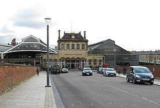
Preston railway station in Preston, Lancashire, England, is a major station on the West Coast Main Line, roughly half-way between London Euston and Glasgow Central. It is served by Avanti West Coast, Northern Trains and TransPennine Express services, plus Caledonian Sleeper overnight services between London and Scotland. It is also served by the Calder Valley line to Leeds and York, and by branch lines to Blackpool, Ormskirk, and Colne.

Southport railway station serves the town of Southport, Merseyside, England. The station is the terminal of the Southport branch of the Northern Line of the electric Merseyrail network, and the diesel-operated Manchester-Southport Line. It is the fourth busiest station on the Merseyrail network. The station and services to Liverpool and Hunts Cross are operated by Merseyrail, with Manchester services operated by Northern Trains.

Meols Cop railway station serves the Blowick suburb of the coastal town of Southport, Merseyside, England. The station has an island platform and is served by Northern Trains‘ Manchester Victoria/Manchester Piccadilly - Southport via Wigan Wallgate branch services, on which it is the last stop before the terminus.
There have been three locations for Fleetwood railway station in Fleetwood, Lancashire, England. The first, from 1840 to 1883, was in Dock Street, opposite Church Street. The second, from 1883 to 1966, was in Queen's Terrace. From 1966 to 1970, the station previously known as Wyre Dock railway station was renamed "Fleetwood".

Deepdale railway station was on the Longridge Branch Line in Preston, Lancashire, England.

Grimsargh railway station was on the single track Preston and Longridge Railway. It served the village of Grimsargh in Lancashire, England.
Longridge railway station was a passenger terminus of the Preston and Longridge Railway. It served the town of Longridge in Lancashire, England.
Whittingham is a civil parish in the City of Preston, Lancashire, England. The parish measures 4 miles (6 km) east-to-west, from the outskirts of Longridge to the outskirts of Broughton, but only 1 mile (1½ km) north-to-south. Its population was 2,189 in 2001, reducing to 2,027 at the time of the 2011 Census. The village of Goosnargh is at its centre.
The Preston and Longridge Railway (P&LR) was a branch line in Lancashire, England. Originally designed to carry quarried stone in horse-drawn wagons, it became part of an ambitious plan to link the Lancashire coast to the heart of Yorkshire. The ambition was never achieved, but the line continued to carry passengers until 1930 and goods until 1967.

Ribbleton railway station was on the Preston and Longridge Railway in Ribbleton, a suburb of Preston, Lancashire, England.
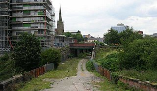
Maudland Bridge railway station was once the Preston terminus of the Longridge Branch Line, in Lancashire, England. It was located on Maudland Road, between a bridge over the Lancaster Canal and Cold Bath Street. The Maudlands district of Preston gets its name from the medieval St. Mary Magdalen's leper hospital, which once stood near the present-day St Walburge's Church.
Longton Bridge was a railway station on the West Lancashire Railway in England. It served the village of Longton.
Deepdale Street railway station was the original Preston terminus of the Preston and Longridge Railway in Lancashire, England, when it first opened in 1840. It was located in Deepdale Street, off Deepdale Road, on what was then the outskirts of Preston. The rail line was originally designed to carry quarried stone from Longridge to Preston, so the passenger facilities were quite rudimentary and there were many sidings near the station for unloading stone.
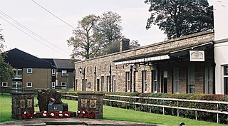
The Whittingham Hospital Railway (W.H.R.) was a private light railway operated by Lancashire County Council to serve Whittingham lunatic asylum. Opened in 1889, it carried goods and passengers between Grimsargh on the Preston and Longridge Railway and the hospital grounds. It closed to all traffic in 1957.
The original Lytham railway station was the Lytham terminus of a branch of the Preston and Wyre Joint Railway from Kirkham in Lancashire, England. It opened, along with the branch, on 16 February 1846; the road it was located in became known as Station Road. It was built in a Renaissance style from Longridge stone. A branch was also built to the dock at Lytham Pool.

Preston is a city in Lancashire, around 50 kilometres (31 mi) north-west of Manchester.

The first Lancaster railway station was the northern terminus of the Lancaster and Preston Junction Railway, located in the Greaves area of the city of Lancaster, Lancashire, England. It was open from 1840 to 1849, by which time it had been superseded by Lancaster Castle railway station. Some books refer to the station as "Lancaster (Greaves)" or "Lancaster " to distinguish it from later stations in the city, although whilst open it was known simply as "Lancaster" as there was no other station of that name at the same time.
Maxwell House railway station served Preston, Lancashire, England, from 1842 to 1844 on the Lancaster and Preston Junction Railway.


