Star Hill, Delaware | |
|---|---|
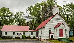 Star Hill AME Church | |
 Star Hill  Star Hill | |
| Coordinates: 39°06′19″N75°32′26″W / 39.10528°N 75.54056°W | |
| Country | United States |
| State | Delaware |
| County | Kent |
| Elevation | 36 ft (11 m) |
| Time zone | UTC-5 (Eastern (EST)) |
| • Summer (DST) | UTC-4 (EDT) |
| Area code | 302 |
| GNIS feature ID | 214689 [1] |
Star Hill is an unincorporated community in Kent County, Delaware, United States. Star Hill is located at the intersection of U.S. Route 13 and Voshells Mill Road/Voshells Mill Star Hill Road, south of Camden. [2]
Star Hill was an early community of African American settlement in Kent County. The Star Hill AME Church is located in Star Hill; the church served as a safe haven along the Underground Railroad and held anti-slavery meetings. [3] Today the church is home to the Star Hill Museum, which features exhibits about African American history in Kent County, slavery and the Underground Railroad. [4]
