
Sterling County is a county located on the Edwards Plateau in the U.S. state of Texas. As of the 2020 census, its population was 1,372, making it the ninth-least populous county in Texas. Its county seat is Sterling City. The county is named for W. S. Sterling, an early settler in the area. Sterling County was one of 30 prohibition, or entirely dry, counties in the state of Texas, but is now a moist county.
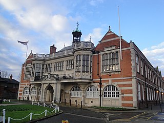
Hendon is an urban area in the London Borough of Barnet, northwest London 7 miles (11 km) northwest of Charing Cross. Hendon was an ancient manor and parish in the county of Middlesex and a former borough, the Municipal Borough of Hendon; it has been part of Greater London since 1965. Hendon falls almost entirely within the NW4 postcode, while the West Hendon part falls in NW9. Colindale to the northwest was once considered part of Hendon but is today separated by the M1 motorway.

Wells is a town in Hamilton County, New York, United States. The population was 674 at the 2010 census. The town is named after Joshua Wells, a land agent, who built the first mills in the area. It is in the Adirondack Park and on the eastern border of the county. It is northwest of Schenectady.

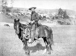
A cowboy is an animal herder who tends cattle on ranches in North America, traditionally on horseback, and often performs a multitude of other ranch-related tasks. Cattle drives ensure the herds' health in finding pasture and bring them to market. The historic American cowboy of the late 19th century arose from the vaquero traditions of northern Mexico and became a figure of special significance and legend. A subtype, called a wrangler, specifically tends the horses used to work cattle. In addition to ranch work, some cowboys work for or participate in rodeos. Cowgirls, first defined as such in the late 19th century, had a less well-documented historical role, but in the modern world work at identical tasks and have obtained considerable respect for their achievements. Cattle handlers in many other parts of the world, particularly in South America and stockmen and jackaroos in Australia, perform work similar to the cowboy.
The American frontier, also known as the Old West, and popularly known as the Wild West, encompasses the geography, history, folklore, and culture associated with the forward wave of American expansion in mainland North America that began with European colonial settlements in the early 17th century and ended with the admission of the last few contiguous western territories as states in 1912. This era of massive migration and settlement was particularly encouraged by President Thomas Jefferson following the Louisiana Purchase, giving rise to the expansionist attitude known as "manifest destiny" and historians' "Frontier Thesis". The legends, historical events and folklore of the American frontier, known as the frontier myth, have embedded themselves into United States culture so much so that the Old West, and the Western genre of media specifically, has become one of the defining features of American national identity.

North West is a province of South Africa. Its capital is Mahikeng. The province is located to the west of the major population centre and province of Gauteng and south of Botswana.
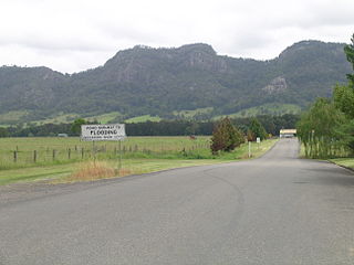
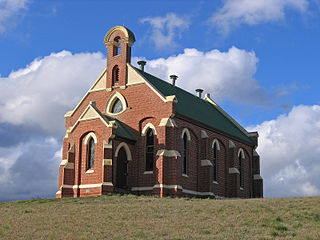
Gloucester, a town in dairy and beef cattle country, is located in Mid-Coast Council, within the Barrington Coast hinterland of the lower Mid North Coast of the state of New South Wales, Australia. It is the closest town to world heritage Barrington Tops National Park.

Blaydon is a town in the Metropolitan Borough of Gateshead, Tyne and Wear, England, and historically in County Durham. Blaydon, and neighbouring Winlaton, which Blaydon is now contiguous with, form the town of Blaydon-on-Tyne. The Blaydon/Winlaton ward had a population in 2011 of 13,896.
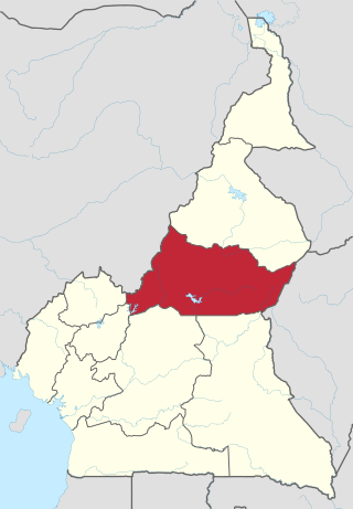
The Adamawa Region is a constituent region of the Republic of Cameroon. It borders the Centre and East regions to the south, the Northwest and West regions to the southwest, Nigeria to the west, the Central African Republic (CAR) to the east, and the North Region to the north.

Moyo District is a district in Northern Region of Uganda. Like many other Ugandan districts, it is named after its "chief town", Moyo, where the district headquarters are located.
Benambra is a small town 28 kilometres (17 mi) north-east of Omeo and 430 kilometres (267 mi) east of the state capital Melbourne, in the Australian Alps of East Gippsland, Victoria, Australia. Nearby towns include Swifts Creek, Ensay, and the major town of Bairnsdale. At the 2016 census, Benambra and the surrounding area had a population of 149.

Loughborough Junction is an area of South London, in the London Borough of Lambeth, which is located equidistant between Brixton, Camberwell and Herne Hill.
Phokeng is a town in Rustenburg of the North West province of South Africa. It is the capital of the Royal Bafokeng Nation. Historically, it was known as Magatostad among white South Africans.

There is evidence of prehistoric human habitation in the region known today as the U.S. state of Wyoming stretching back roughly 13,000 years. Stone projectile points associated with the Clovis, Folsom and Plano cultures have been discovered throughout Wyoming. Evidence from what is now Yellowstone National Park indicates the presence of vast continental trading networks since around 1,000 years ago.
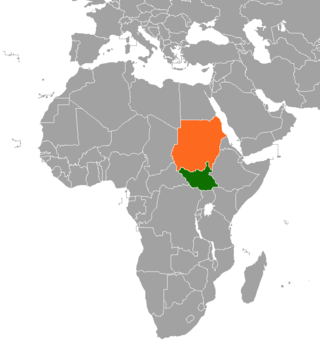
Sudanese nomadic conflicts are non-state conflicts between rival nomadic tribes taking place in the territory of Sudan and, since 2011, South Sudan. Conflict between nomadic tribes in Sudan is common, with fights breaking out over scarce resources, including grazing land, cattle and drinking water. Some of the tribes involved in these clashes have been the Messiria, Maalia, Rizeigat and Bani Hussein Arabic tribes inhabiting Darfur and West Kordofan, and the Dinka, Nuer and Murle African ethnic groups inhabiting South Sudan. Conflicts have been fueled by other major wars taking place in the same regions, in particular the Second Sudanese Civil War, the War in Darfur and the Sudanese conflict in South Kordofan and Blue Nile.
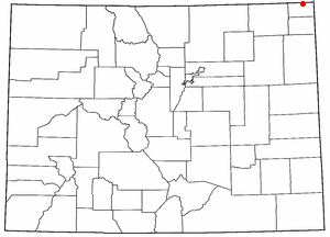
The Battle of Julesburg took place on January 7, 1865, near Julesburg, Colorado between 1,000 Cheyenne, Arapaho, and Lakota Indians and about 60 soldiers of the U.S. army and 40 to 50 civilians. The Indians defeated the soldiers and over the next few weeks plundered ranches and stagecoach stations up and down the South Platte River valley.

Long Island is an island in The Bahamas that is split by the Tropic of Cancer. It is one of the Districts of the Bahamas and is known as the most scenic island in the Bahamas. Its capital is Clarence Town. The population of Long Island is 3,094 inhabitants.
The Kalkadoon Wars were a series of violent encounters between European colonists and the Kalkadoon people of Australia.
A cattle town was a frontier settlement in the Midwestern United States that catered to the cattle industry. The economies of these communities were heavily dependent on the seasonal cattle drives from Texas, which brought the cowboys and the cattle that these towns relied upon. Cattle towns were found at the junctions of railroads and livestock trails. These towns were the destination of the cattle drives, the place where the cattle would be bought and shipped off to urban meatpackers, midwestern cattle feeders, or to ranchers on the central or northern plains. Cattle towns were made famous by popular accounts of rowdy cowboys and outlaws who were kept under control by local lawmen, but those depictions were mostly exaggeration and myth.
Cloncurry–Dajarra Road is a continuous 169 kilometres (105 mi) road route in the Cloncurry local government area of Queensland, Australia. It is a state-controlled district road rated as a local road of regional significance (LRRS). It is a north-east to south-west link between the Barkly Highway and the Diamantina Developmental Road, servicing a number of cattle grazing and production areas in northern Queensland.


