
West Boylston is a town in Worcester County, Massachusetts, United States and a northern suburb of Worcester. The population was 7,877 at the 2020 census. West Boylston includes the village of Oakdale, located on the opposite side of the Wachusett Reservoir from West Boylston center along Route 140. Although the town was split off from Boylston, it has a larger population than its eastern namesake.
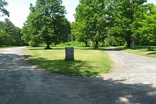
Dana was a town located in Worcester County, Massachusetts, United States. Dana was lost as a result of the formation of the Quabbin Reservoir.
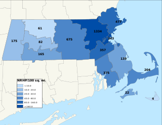
The National Register of Historic Places is a United States federal official list of places and sites considered worthy of preservation. In the state of Massachusetts, there are over 4,300 listings, representing about 5% of all NRHP listings nationwide and the second-most of any U.S. state, behind only New York. Listings appear in all 14 Massachusetts counties.

Charlton Center Historic District is an historic district roughly on Main Street from Mugget Hill Road to Masonic Home Road and adjacent roads in Charlton, Massachusetts. The district, which encompasses the historic center of the town, includes the first architect-designed building in the center, the Shingle style Overlook Hotel designed by Worcester architect George H. Clemence, as well as the 1905 Colonial Revival Town Hall designed by Frost, Briggs & Chamberlain. The town hall site is also home to a number of memorials to the town's military.

The Mendon Center Historic District is a historic district encompassing the village center of Mendon, Massachusetts, and some of its surrounding rural areas. It is roughly bounded by Main, Hastings, Maple, North, Washington & George Streets. The village is centered on the triangle defined by Main, Hastings, and Maple Streets, with dwellings built up on the roads that radiate away from this area. Founders' Park, located at the junction of Main, Hastings, North and Milford Streets, is the site of the original town center, where the first meeting house was located. The district has residential buildings dating from the 18th to the mid-20th centuries, in a wide variety of styles. The focal point of the town center is the Second Unitarian Church, an 1820 building designed by Worcester architect Elias Carter.

Westminster Village–Academy Hill Historic District encompasses the historic first town center of Westminster, Massachusetts, as well as its later early-19th century commercial core. Centered at the junction Main and South Streets with Academy Hill Road, it contains fine examples of Colonial, Federal, and Greek Revival architecture, including the 1839 town hall. The district was listed on the National Register of Historic Places in 1983.

The Harvard Center Historic District is a historic district encompassing the traditional village center of Harvard, Massachusetts, USA. The district is centered on the town common, a triangular grassy space bounded by Elm Street, Still River Road, and Ayer Road. The common is ringed by residences, civic and religious buildings, and a small commercial area. The common was laid out when the town was founded in 1732, and has grown, mainly in periods of growth at the late 18th and late 19th/early 20th centuries. Most of the village's buildings post-date 1831. The district was added to the National Register of Historic Places in 1997.

The West Brookfield Center Historic District is a historic district encompassing the historic center of West Brookfield, Massachusetts. When first listed on the National Register of Historic Places in 1990, it was centered on the triangular junction of Main Street, North Main Street, and School Street, extending away from this area along Main Street, North Main Street, and Foster Hill Road. A few of its properties lie on side streets adjacent to these roads. This area represented the core of Brookfield, before it was broken into smaller communities, including West Brookfield. It has a fine collection of 18th and 19th century homes, ranging stylistically from Federal to Queen Anne, as well as the town hall and public library.
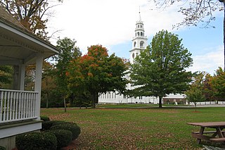
The Templeton Common Historic District encompasses the historic town center of Templeton, Massachusetts. Laid out in the 1750s, the area has been the focus of the town's civic and economic affairs since, and includes its finest assortment of 18th and early 19th-century architecture. The district was added to the National Register of Historic Places in 1983. The district was in 2010 named as one of the 1,000 places to visit in Massachusetts by the Great Places in Massachusetts Commission.
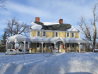
The Russell Corner Historic District of Princeton, Massachusetts encompasses a small 19th century commercial center that developed into a summer resort area by the early 20th century. Centered at the intersection of Merriam Road and Gregory Hill Road, the district includes fifteen contributing buildings on 124 acres (50 ha), which are predominantly residential in nature, and were mostly built before 1830. Some of the properties are found on East Princeton and Sterling Roads, and Bullock Lane. The district was listed on the National Register of Historic Places in 2006.

The Spencer Town Center Historic District encompasses the historic downtown of Spencer, Massachusetts. When first listed on the National Register of Historic Places in 1986, the district covered 250 acres (100 ha) centered on Main Street between High and North Streets. A major expansion, the East Main Street – Cherry Street Historic District, added 45 acres (18 ha) of a predominantly residential area east of the center. The district was expanded twice in 2003, adding residential areas along Grove, Prouty, Pleasant, High, and Main Streets, and industrial areas on Cherry, Wall, and Mechanic Streets, as well as Luther Hill Park. The main period of historic interest is the peak period of Spencer's industrial history in the last quarter of the 19th century, although there are a significant number of properties that predate this period.

The Wayside Inn Historic District is a historic district on Old Boston Post Road in Sudbury, Massachusetts. The district contains the Wayside Inn, a historic landmark that is one of the oldest inns in the country, operating as Howe's Tavern in 1716. The district features Greek Revival and American colonial architecture. The area was added to the National Register of Historic Places in 1973.
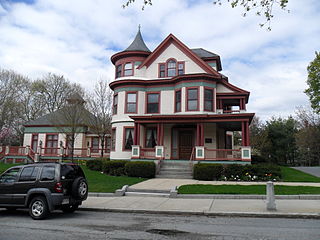
The Woodland Street Historic District is a historic housing district in the Main South area of Worcester, Massachusetts. It consists of 19 Victorian houses that either face or abut on Woodland Street, between Charlotte and Oberlin Streets. The district was listed on the National Register of Historic Places in 1980. Located directly adjacent to the campus of Clark University, some of the buildings are used by Clark for housing and administration.

The View Street Historic District is a residential historic district in Worcester, Massachusetts. It contains eleven triple decker houses, nine of which are particularly well preserved. They were built between 1916 and 1930, during the late phase of triple decker construction in the Vernon Hill area, and have Colonial Revival styling. The district was listed on the National Register of Historic Places in 1990.

Indian Hill-North Village is a residential historic district encompassing the largest planned worker housing community in Worcester, Massachusetts. Located in the suburban northern part of the city, it was developed in the 1910s by the Norton Company, then the city's largest employer. The district was listed on the National Register of Historic Places in 1980.
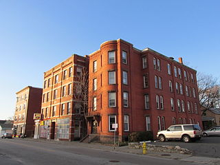
Oxford–Crown Historic District is a historic district roughly bounded by Chatham, Congress, Crown, Pleasant, Oxford Streets and Oxford Place in Worcester, Massachusetts.

The Brookline Town Green Historic District encompasses the historic colonial heart of the town of Brookline, Massachusetts. Centered on a stretch of Walnut Street between Warren and Chestnut Streets, this area is where the town's first colonial meeting house and cemetery were laid out, and was its center of civic life until the early 19th century. The district was listed on the National Register of Historic Places in 1980.

The West Village Historic District of Princeton, Massachusetts, encompasses the historic heart of its West Village. The 465-acre (188 ha) district abuts the Princeton Center Historic District to the east, and was listed on the National Register of Historic Places in 2009.
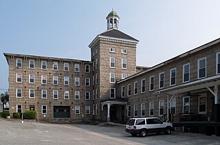
The Manchaug Village Historic District is a historic district encompassing the 19th century industrial village center of Manchaug in Sutton, Massachusetts. Developed in the 1820s around textile mills on the Mumford River, it was the largest industrial area in Sutton, with at least three mill complexes in operation. The district is centered on the junction of Main Street with Manchaug, Putnam Hill, and Whitins Roads.

The Dudley Hill Historic District encompasses the historic heart of Dudley, Massachusetts. The historic district is essentially linear, extending along Center Street between Dudley Hill and Tanyard Roads. This area was the first to be settled in the mid-17th century, and is composed mainly of civic, religious, and residential buildings dating to the 18th and 19th centuries. The district listed on the National Register of Historic Places in 2001.


