John C. Frémont was the first European-American to see Lake Tahoe, during his second exploratory expedition.[6] He and Charles Preuss saw the lake from the summit of what was likely Stevens Peak (or possibly Red Lake Peak) on February 14, 1844.[7][8]
This landform's toponym has been officially adopted by the U.S. Board on Geographic Names,[5] and has been in use since at least 1896 when published by the Sierra Club.[9] The name honors Alpine County supervisor J. M. Stevens who operated a stage station in Hope Valley from 1864 through 1866.[2] The USGS surveyed this area in 1889 and labelled the geographic feature on their map.[10]
Climate
According to the Köppen climate classification system, Stevens Peak is located in an alpine climate zone.[11] Most weather fronts originate in the Pacific Ocean and travel east toward the Sierra Nevada mountains. As fronts approach, they are forced upward by the peaks (orographic lift), causing them to drop their moisture in the form of rain or snowfall onto the range.
Gallery
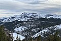
North aspect in winter, from Waterhouse Peak
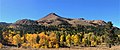
Northeast aspect of Stevens Peak from Hope Valley
Southeast aspect
East aspect of Stevens Peak in Hope Valley
Southeast aspect
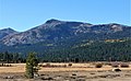
Northeast aspect of Stevens Peak (right of center) from Hope Valley
Northeast aspect of Stevens Peak (right) from Hope Valley. Red Lake Peak to left.
This page is based on this Wikipedia article Text is available under the CC BY-SA 4.0 license; additional terms may apply. Images, videos and audio are available under their respective licenses.