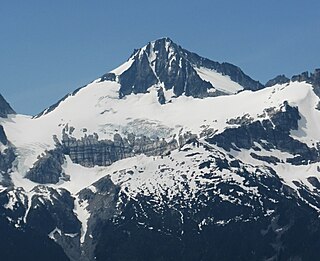
Columbia Peak is a mountain peak in the Henry M. Jackson Wilderness in the U.S. state of Washington. Columbia Peak rises to 7,172 feet (2,186 m). Together with Monte Cristo Peak and Kyes Peak it forms a basin that contains Columbia Glacier and Blanca Lake.
Lady Peak is a mountain located just southeast of Cheam Peak in the Cheam Range near Chilliwack, British Columbia. It is west of the four peaks in the eastern portion of the range known as The Lucky Four Group or The Lucky Four, consisting of Knight, Foley, Stewart and Welch peaks.
North Gardner Mountain is a mountain in the North Cascades of Washington state. The mountain is located in the Okanogan–Wenatchee National Forest and is the highest point in Okanogan County, Washington, and the 23rd highest mountain in the state.

Welch Peak is a 2,431-metre (7,976-foot) mountain summit in the Cheam Range, located in southwestern British Columbia, Canada, near Chilliwack. It is the highest summit in the range. The mountain is named after one of the partners in the engineering firm Foley, Welch and Stewart who built and operated the Lucky Four Mine located near the peak. Nearby peaks are also named after the other partners.

Klawatti Peak is located in North Cascades National Park in the U.S. state of Washington. Klawatti Peak is a nunatak, a peak surrounded by glaciers. These are Klawatti Glacier to the east, McAllister Glacier to the northwest and Inspiration Glacier to the south.
Primus Peak is located in North Cascades National Park in the U.S. state of Washington. Primus Peak is flanked by North Klawatti Glacier to the south and Borealis Glacier to the northeast. Tricouni Peak is situated immediately east of Primus Peak.

McMillan Spire is a mountain peak in the Picket Range in the U.S. state of Washington and within North Cascades National Park. The peak lies .75 mi (1.21 km) east of Mount Degenhardt, and 0.47 mi (0.76 km) east of Inspiration Peak. The subpeak known as East McMillan Spire is .14 mi (0.23 km) east of McMillan Spire and they are collectively referred to as the McMillan Spires. The Terror Glacier lies to the west of the peak.

White Chuck Mountain, or native name Hi Khaed, is a 6,989 ft (2,130 m) summit near the western edge of the North Cascades, in Snohomish County of Washington state. It is located southeast of Darrington, Washington, east of the Mountain Loop Highway, and northwest of Glacier Peak, which is one of the Cascade stratovolcanoes. It is situated at the confluence of the White Chuck River and the Sauk River on land administered by the Mount Baker-Snoqualmie National Forest. The mountain is named for the White Chuck River, which "chuck" in Chinook Jargon means "water". The nearest higher neighbor is Mount Pugh, 4.9 miles (7.9 km) to the south-southeast.

Whistler Mountain is a 7,790-foot (2,370-metre) mountain summit located in Chelan County of Washington state. The mountain is part of the Okanagan Range which is a sub-range of the North Cascades. Whistler Mountain is about two miles west of Washington Pass and one mile east of Rainy Pass. The North Cascades Highway bends around the southern base of the mountain between these two passes. A high ridge connects Whistler to its nearest higher neighbor, Cutthroat Peak, which is 0.78 miles (1.26 km) to the north-northeast. Precipitation runoff from the peak drains into Bridge Creek. Topographic relief is significant as the summit rises over 3,000 feet above the creek and highway in approximately one mile.

Azurite Peak is an 8,434-foot (2,571-metre) double-summit mountain located at the common boundary point of Okanogan County, Skagit County, and Whatcom County in Washington state. It is part of the Okanogan Range which is a sub-range of the North Cascades Range. Azurite Peak ranks as the 81st-highest summit in the state. Azurite Peak is situated north of Azurite Pass on land administered by the Okanogan–Wenatchee National Forest. The nearest higher neighbor is Tower Mountain, 5.24 miles (8.43 km) to the south-southeast, and Mount Ballard lies 1.97 miles (3.17 km) to the north. Remnants of a small pocket glacier are found on the east aspect. Precipitation runoff from the peak drains north into tributaries of the Skagit River, and south into the Methow River. Topographic relief is significant as the summit rises over 3,000 feet above Mill Creek in one mile (1.6 km). The Pacific Crest Trail traverses the base of Azurite Peak.

Repulse Peak is a 7,923-foot (2,415-metre) mountain summit in the North Cascades in the U.S. state of Washington. It is located on the border of the Stephen Mather Wilderness and North Cascades National Park. It is situated midway between Black Peak and Fisher Peak, and can be seen from the North Cascades Highway. Precipitation runoff from Repulse Peak drains into tributaries of the Skagit River and Stehekin River. Topographic relief is significant as the east face rises over 2,900 feet in 0.53 mile (0.85 km).
Sheep Mountain is an 8,274-foot (2,522-metre) mountain summit located in Okanogan County in Washington state. It is part of the Okanogan Range which is a sub-range of the North Cascades and Cascade Range. The mountain is situated less than 2 miles (3.2 km) south of the Canada–United States border, on the east side of the Cascade crest, in the Pasayten Wilderness, on land managed by the Okanogan–Wenatchee National Forest. The nearest higher peak is Andrew Peak, 8.3 miles (13.4 km) to the east-southeast. The Pacific Northwest Trail traverses the slopes of Sheep Mountain as it crosses Peeve Pass. Precipitation runoff from Sheep Mountain drains west into Peeve Creek, or east into tributaries of Ashnola River. The mountain was so named because for 40 years the meadows surrounding it were prime grazing land for sheep in the summer, before the protection of wilderness designation.

Tiffany Mountain is an 8,245-foot (2,513-metre) mountain summit located in Okanogan County in Washington state. It is the highest point in the Tiffany Range, which is a sub-range of the Okanogan Range. The mountain is situated on the east side of the Cascade crest, on land managed by the Okanogan–Wenatchee National Forest. The nearest higher peak is Windy Peak, 18 miles (29 km) to the north. Precipitation runoff from Tiffany Mountain drains into tributaries of the Columbia River.

Vicuna Peak, or Vicuña Peak, is a 2,126-metre (6,975-foot) granitic horn located in the North Cascades of southwestern British Columbia, Canada. It is situated 8 km (5 mi) northwest of Coquihalla Summit, 1.47 km (1 mi) northeast of Alpaca Peak, and 1 km (1 mi) southwest of Guanaco Peak, its nearest higher peak, by a mere one metre. Precipitation runoff from the peak drains west into headwaters of the East Anderson River, or east into headwaters of the Coldwater River. The mountain was named for the vicuña, as part of the animal names theme for several other nearby peaks that were submitted by Philip Kubik of the 1974 first ascent party. The mountain's name was officially adopted on February 5, 1976, by the Geographical Names Board of Canada.

Frosty Mountain is a 2,426-metre (7,959-foot) mountain summit located in the Canadian Cascades of southwestern British Columbia, Canada. It is situated 4 km (2 mi) south of Lightning Lake, 1.3 km (1 mi) north of the Canada–United States border, and 3.6 km (2 mi) north-northeast of Castle Peak, which is its nearest higher peak. Frosty Mountain is the highest peak in E. C. Manning Provincial Park, and is part of the Hozameen Range which is a subrange of the Cascade Range. It has a lower elevation subsidiary peak known as Frosty Mountain East which is labelled as Frosty Mountain on some maps. The Frosty Mountain name was officially adopted on March 31, 1924, by the Geographical Names Board of Canada. The peak was first climbed on September 2, 1904, by Sledge Tatum and George Loudon Jr., two members of a Boundary Survey group led by Edward C. Barnard. Precipitation runoff from the peak drains into headwaters of Frosty Creek, as well as other tributaries of the Similkameen River.

Williams Peak is a prominent 2,123-metre (6,965-foot) mountain summit located in the Chilliwack River valley of the Cascade Mountains in southwestern British Columbia, Canada. It is situated 14 km (9 mi) north of the Canada–United States border, 6 km (4 mi) northwest of Chilliwack Lake, and 6.7 km (4 mi) southeast of Foley Peak, which is its nearest higher peak. Williams Peak is the highest point of the South Hope Mountains, which is a subset of the Skagit Range. Precipitation runoff from the peak drains into tributaries of the Chilliwack River. The mountain's name was officially adopted April 7, 1955, by the Geographical Names Board of Canada. Williams Peak was first climbed July 1908 by James J. McArthur and E.T. de Coeli via the southwest ridge.
Mount Outram is a prominent 2,461-metre (8,074-foot) mountain summit located in the Canadian Cascades of southwestern British Columbia, Canada. It is the fourth-highest summit in the Hozameen Range, and highest point of the Manson Ridge subrange. It is situated 23 km (14 mi) southeast of Hope, and 14.5 km (9 mi) north-northeast of Silvertip Mountain, its nearest higher peak. Precipitation runoff from the peak drains into tributaries of the Coquihalla and Skagit Rivers. The mountain was known as Beaver Mountain as early as 1930 before being named for Sir James Outram, 1st Baronet, and being officially adopted October 6, 1936, by the Geographical Names Board of Canada. The first ascent of the mountain was made August 12, 1924, by Fred Perry, Herbert Selwood, Leslie Ford, and T.L. Thacker.
Easy Peak is a 6,613-foot (2,016-metre) mountain summit in the Skagit Range of the North Cascades, in Whatcom County of Washington state. Easy Peak is situated in North Cascades National Park, and is often climbed during the Easy Ridge approach to Mount Challenger and the remote northern Pickets. The nearest higher neighbor is Mineral Mountain, 2 mi (3.2 km) to the west, and Whatcom Peak is set 2.1 mi (3.4 km) to the east. Glacierets line the north slope of Easy Ridge between Easy Peak and Whatcom Peak. Precipitation runoff from this peak drains north into the Chilliwack River, or south into headwaters of the Baker River.
Baby Munday Peak is a 2,250-meter-elevation (7,382-foot) mountain summit located in the Cheam Range of British Columbia, Canada.

Knight Peak is a 2,235-metre-elevation (7,333-foot) mountain summit located in the Cheam Range of British Columbia, Canada.


