| Baby Munday Peak | |
|---|---|
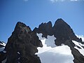
 Southwest aspect | |
| Highest point | |
| Elevation | 2,250 m (7,382 ft) [1] |
| Prominence | 230 m (755 ft) [1] |
| Parent peak | Welch Peak (2,431 m) [2] |
| Isolation | 1.35 km (0.84 mi) [1] |
| Listing | Mountains of British Columbia |
| Coordinates | 49°10′00″N121°37′42″W / 49.16667°N 121.62833°W [3] |
| Naming | |
| Etymology | Edith Munday |
| Geography | |
 Baby Munday Peak Location in British Columbia  Baby Munday Peak Location in Canada | |
 | |
| Interactive map of Baby Munday Peak | |
| Country | Canada |
| Province | British Columbia |
| District | Yale Division Yale Land District [4] |
| Parent range | Cascade Range North Cascades Cheam Range |
| Topo map | NTS 92H4 Chilliwack [3] |
| Geology | |
| Mountain type | Fault block |
| Climbing | |
| First ascent | 1933 |
| Easiest route | Southeast ridge [5] |
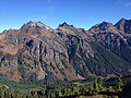
Baby Munday Peak is a 2,250-meter-elevation (7,380-foot) mountain summit located in the Cheam Range of British Columbia, Canada. [4]