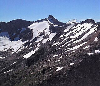
The Cheam Range is a mountain range in the Fraser Valley region of the Lower Mainland of British Columbia near the city of Chilliwack. The region is also a part of the Skagit Range of the Canadian Cascades and contains many rugged peaks.

Canadian Border Peak, 2,291 metres (7,516 ft), originally known simply as Border Peak, is a mountain at the head of Tamihi Creek in the Cascade Mountains of the Lower Mainland of British Columbia, Canada. As its name suggests, it is near the Canada–US border and is connected via a high ridge or col to American Border Peak, which is slightly higher at 2,437 metres (7,995 ft). The two together are known as the Border Peaks or American-Canadian Border Peaks and are most easily visible within nearby settled parts of Canada from the northern part of Sumas Prairie and the western part of Chilliwack Prairie in the area of Greendale, which is just east of the boundary between the cities of Chilliwack and Abbotsford.

Mount Redoubt is a mountain in the North Cascades range in Whatcom County, Washington state. The peak is located 3.0 miles (5 km) from the Canada–US border, 16.3 miles (26 km) east-northeast of Mount Shuksan. It is the 21st highest peak in the state, with a height of 8,956 feet (2,730 m) and a prominence of 1,649 feet (503 m). Redoubt is in the Skagit Range, a sub-range of the North Cascades, in the Custer-Chilliwack Group which includes Mount Spickard, Mount Redoubt, Mount Custer and Mox Peaks, among others. Redoubt, Bear, and Depot creeks drain off the mountain, which is composed of Skagit gneiss. Mount Redoubt is listed as one of the "Classic Eight Peaks" in the North Cascades.

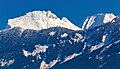
Welch Peak is a 2,431-metre (7,976-foot) mountain summit in the Cheam Range, located in southwestern British Columbia, Canada, near Chilliwack. It is the highest summit in the range. The mountain is named after one of the partners in the engineering firm Foley, Welch and Stewart who built and operated the Lucky Four Mine located near the peak. Nearby peaks are also named after the other partners.

Stewart Peak is a 2,238-metre (7,343-foot) mountain in the Cheam Range, located in southwestern British Columbia, Canada near Chilliwack. It is situated west of The Still Peak and east of Baby Munday Peak. The mountain is named after one of the partners in the engineering firm Foley, Welch and Stewart who built and operated the Lucky Four Mine located near the peak. Nearby peaks are also named after the other partners.

Bear Mountain is a remote 7,931-foot (2,417-metre) mountain summit in the Skagit Range of the North Cascades of Washington state. Bear Mountain is situated in North Cascades National Park. Its nearest higher peak is Mount Redoubt, 2.36 mi (3.80 km) to the northeast. Precipitation runoff from Bear Mountain drains into Bear Creek and Indian Creek, both tributaries of the Chilliwack River. Access, either by the Chilliwack River Trail or from British Columbia, Canada, is difficult and takes two to three days.

Mineral Mountain is a 6,800-foot (2,100-metre) mountain summit in the Skagit Range of the North Cascades of Washington state. Mineral Mountain is situated in North Cascades National Park and the summit offers views of Mount Shuksan, Icy Peak, and the Picket Range. Easy Peak is set 2 mi (3.2 km) to the east, and the nearest higher neighbor is Ruth Mountain, 3.06 mi (4.92 km) to the west. Precipitation runoff from Mineral Mountain finds its way north into the Chilliwack River, and south into the Baker River.

Nodoubt Peak is a remote 7,290-foot (2,220-metre) mountain summit in the Skagit Range of the North Cascades of Washington state. Nodoubt Peak is situated in North Cascades National Park, 2.2 kilometres south of the Canada–United States border. The nearest higher peak is Canuck Peak, 1.43 mi (2.30 km) to the southeast, and Mount Redoubt rises 3.04 mi (4.89 km) also to the southeast of Nodoubt. Nodoubt Peak was named by a group of geologists who climbed the peak in 1967. The toponym is a word play on Mount Redoubt's name. Precipitation runoff from Nodoubt Peak drains into tributaries of the Chilliwack River.

Mount Rexford is a prominent 2,329-metre (7,641-foot) mountain summit located in the Cascade Mountains of southwestern British Columbia, Canada. It is situated 3.5 km (2 mi) north of the Canada–United States border, 7 km (4 mi) west of Chilliwack Lake, and 5.5 km (3 mi) east of Slesse Mountain, which is its nearest higher neighbor. Precipitation runoff from the peak drains into Nesakwatch and Centre Creeks, both tributaries of the Chilliwack River. Originally known as Ensawkwatch, the mountain was named for an early settler in the area, Rexford, who had a cabin near Slesse Creek and had trap lines in the vicinity. The mountain has two subsidiary peaks known as the Nesakwatch Spires. The mountain's name was officially adopted on June 2, 1950, by the Geographical Names Board of Canada. Mount Rexford was first climbed in July 1951 by Herman Genschorek and Walt Sparling via the West Ridge.

Mount McGuire is a 2,008-metre (6,588-foot) mountain summit located in the Cascade Mountains of southwestern British Columbia, Canada. It is situated 4 km (2 mi) north of the Canada–United States border, 19 km (12 mi) southeast of Chilliwack, and 7.4 km (5 mi) northwest of Canadian Border Peak, which is its nearest higher peak. Precipitation runoff from the peak drains into tributaries of the Chilliwack River. The steep western slope of the peak plunges 1800 metres into Tamihi Creek. The mountain was originally known as Tamihi, a Halkomelem name that means "deformed baby finishes." Such infants were sometimes left exposed on the mountain to die. The mountain's name was labelled on 1917 map as McGuire, and officially adopted on October 6, 1936, by the Geographical Names Board of Canada. The peak was first climbed in 1906 by James J. McArthur and survey party via the Southeast Ridge.

Crossover Peak is a 2,175-metre (7,136-foot) mountain summit located in the Cascade Mountains of southwestern British Columbia, Canada. It is situated 4.5 km (3 mi) north of the Canada–United States border, 1.6 km (1 mi) southeast of Mount MacFarlane, and 2 km (1 mi) north-northwest of Slesse Mountain, which is its nearest higher peak. Precipitation runoff from the peak drains into Slesse Creek and Nesakwatch Creek, both tributaries of the Chilliwack River. The mountain's name was submitted by Glenn Woodsworth of the Alpine Club of Canada based on the popular cross-over hike from the Pierce Lake trail to the Slesse trail on opposite sides of the peak. The name was officially adopted on May 21, 1981, by the Geographical Names Board of Canada.
Mount Outram is a prominent 2,461-metre (8,074-foot) mountain summit located in the Canadian Cascades of southwestern British Columbia, Canada. It is the fourth-highest summit in the Hozameen Range, and highest point of the Manson Ridge subrange. It is situated 23 km (14 mi) southeast of Hope, and 14.5 km (9 mi) north-northeast of Silvertip Mountain, its nearest higher peak. Precipitation runoff from the peak drains into tributaries of the Coquihalla and Skagit Rivers. The mountain was known as Beaver Mountain as early as 1930 before being named for Sir James Outram, 1st Baronet, and being officially adopted October 6, 1936, by the Geographical Names Board of Canada. The first ascent of the mountain was made August 12, 1924, by Fred Perry, Herbert Selwood, Leslie Ford, and T.L. Thacker.

Mount Payne is a 2,468-metre (8,097-foot) mountain summit located in the Canadian Cascades of southwestern British Columbia, Canada. It is situated 27 km (17 mi) southeast of Hope, 14 km (9 mi) northeast of Chilliwack Lake, and 4 km (2 mi) west of Silvertip Mountain, which is its nearest higher peak. Following Silvertip, Mount Payne is the second-highest summit in the Hope Mountains, a subset of the Skagit Range. The peak was first climbed in 1950 by J. Bussell, H. Genschorek, I. Kay, A. Melville, and W. Sparling. The peak was named for Damasus Payne, a Benedictine monk and mountaineer who fell to his death on Edge Peak in 1978. Payne was responsible for naming mountains such as Mount Rohr and Mount Duke. He also carried all the materials for mass and communion up to the summit of Slesse Mountain to perform a ceremony to honor the victims of Trans-Canada Air Lines Flight 810. Mt. Payne's name was officially adopted May 7, 1984, by the Geographical Names Board of Canada. Precipitation runoff from the peak drains into headwaters of the Sumallo River, and into the Klesilkwa River, which is a tributary of the Skagit.

Indian Mountain is a remote 7,133-foot (2,174-metre) mountain summit in the Skagit Range of the North Cascades, in Whatcom County of Washington state. Indian Mountain is situated in North Cascades National Park, seven miles (11 km) south of the Canada–United States border. The nearest higher neighbor is Red Face Mountain, 1.14 mi (1.83 km) to the southeast, and Whatcom Peak rises 2.9 mi (4.7 km) to the south. Although modest in elevation, relief is significant since this peak rises over 4,100 feet above Brush Creek Valley in approximately one mile. Precipitation runoff from Indian Mountain drains into tributaries of the Chilliwack River.
Middle Peak is a 7,464-foot-elevation (2,275-meter) mountain summit located in the North Cascades in Whatcom County of Washington state, United States.

Mount Lindeman is a 2,312-meter-elevation (7,585-foot) mountain summit located in the North Cascades in British Columbia, Canada.

Mount Webb is a 2,164-meter-elevation (7,100-foot) mountain summit located in the North Cascades in British Columbia, Canada.
Baby Munday Peak is a 2,250-meter-elevation (7,382-foot) mountain summit located in the Cheam Range of British Columbia, Canada.

Knight Peak is a 2,235-metre-elevation (7,333-foot) mountain summit located in the Cheam Range of British Columbia, Canada.
Mount Hatfield is a 2,227-metre (7,306-foot) mountain summit located in the Canadian Cascades of British Columbia, Canada.