Cheam Peak or Mount Cheam.
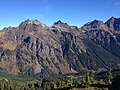
Lady Peak is a mountain located just southeast of Cheam Peak in the Cheam Range near Chilliwack, British Columbia. It is west of the four peaks in the eastern portion of the range known as The Lucky Four Group or The Lucky Four, consisting of Knight, Foley, Stewart and Welch peaks.

Canadian Border Peak, 2,291 metres (7,516 ft), originally known simply as Border Peak, is a mountain at the head of Tamihi Creek in the Cascade Mountains of the Lower Mainland of British Columbia, Canada. As its name suggests, it is near the Canada–US border and is connected via a high ridge or col to American Border Peak, which is slightly higher at 2,437 metres (7,995 ft). The two together are known as the Border Peaks or American-Canadian Border Peaks and are most easily visible within nearby settled parts of Canada from the northern part of Sumas Prairie and the western part of Chilliwack Prairie in the area of Greendale, which is just east of the boundary between the cities of Chilliwack and Abbotsford.

Mount Redoubt is a mountain in the North Cascades range in Whatcom County, Washington state. The peak is located 3.0 miles (5 km) from the Canada–US border, 16.3 miles (26 km) east-northeast of Mount Shuksan. It is the 21st highest peak in the state, with a height of 8,956 feet (2,730 m) and a prominence of 1,649 feet (503 m). Redoubt is in the Skagit Range, a sub-range of the North Cascades, in the Custer-Chilliwack Group which includes Mount Spickard, Mount Redoubt, Mount Custer and Mox Peaks, among others. Redoubt, Bear, and Depot creeks drain off the mountain, which is composed of Skagit gneiss. Mount Redoubt is listed as one of the "Classic Eight Peaks" in the North Cascades.

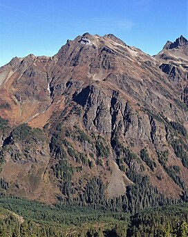
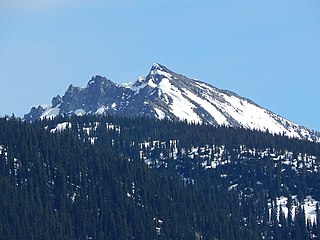
Welch Peak is a 2,431-metre (7,976-foot) mountain summit in the Cheam Range, located in southwestern British Columbia, Canada, near Chilliwack. It is the highest summit in the range. The mountain is named after one of the partners in the engineering firm Foley, Welch and Stewart who built and operated the Lucky Four Mine located near the peak. Nearby peaks are also named after the other partners.

Stewart Peak is a 2,238-metre (7,343-foot) mountain in the Cheam Range, located in southwestern British Columbia, Canada near Chilliwack. It is situated west of The Still Peak and east of Baby Munday Peak. The mountain is named after one of the partners in the engineering firm Foley, Welch and Stewart who built and operated the Lucky Four Mine located near the peak. Nearby peaks are also named after the other partners.

Mount Larrabee is a 7,865-foot (2,397-metre) Skagit Range mountain summit situated 1.4 mile south of the Canada–United States border, in the North Cascades of Washington state. It is located immediately southeast of American Border Peak within the Mount Baker Wilderness, which is part of the Mount Baker-Snoqualmie National Forest, and near North Cascades National Park. It is notable for its reddish coloring caused by oxidation of Iron in the rock. The rock consists of reddish interbedded and interfolded phyllites and greenstone. Originally known as Red Mountain, the name was changed in 1951 to honor Charles F. Larrabee (1895–1950), of the prominent Larrabee family of Bellingham, Washington. The toponym was officially adopted in 1951 by the U.S. Board on Geographic Names.

Tomyhoi Peak is a 7,439-foot (2,267-metre) Skagit Range mountain situated one mile south of the Canada–United States border, in the North Cascades of Washington state. It is located west of Mount Larrabee and within the Mount Baker Wilderness, which is part of the Mount Baker-Snoqualmie National Forest. This mountain's toponym was officially adopted in 1913 by the U.S. Board on Geographic Names.

Mount McGuire is a 2,008-metre (6,588-foot) mountain summit located in the Cascade Mountains of southwestern British Columbia, Canada. It is situated 4 km (2 mi) north of the Canada–United States border, 19 km (12 mi) southeast of Chilliwack, and 7.4 km (5 mi) northwest of Canadian Border Peak, which is its nearest higher peak. Precipitation runoff from the peak drains into tributaries of the Chilliwack River. The steep western slope of the peak plunges 1800 metres into Tamihi Creek. The mountain was originally known as Tamihi, a Halkomelem name that means "deformed baby finishes." Such infants were sometimes left exposed on the mountain to die. The mountain's name was labelled on 1917 map as McGuire, and officially adopted on October 6, 1936, by the Geographical Names Board of Canada. The peak was first climbed in 1906 by James J. McArthur and survey party via the Southeast Ridge.

Williams Peak is a prominent 2,123-metre (6,965-foot) mountain summit located in the Chilliwack River valley of the Cascade Mountains in southwestern British Columbia, Canada. It is situated 14 km (9 mi) north of the Canada–United States border, 6 km (4 mi) northwest of Chilliwack Lake, and 6.7 km (4 mi) southeast of Foley Peak, which is its nearest higher peak. Williams Peak is the highest point of the South Hope Mountains, which is a subset of the Skagit Range. Precipitation runoff from the peak drains into tributaries of the Chilliwack River. The mountain's name was officially adopted April 7, 1955, by the Geographical Names Board of Canada. Williams Peak was first climbed July 1908 by James J. McArthur and E.T. de Coeli via the southwest ridge.

Genesis Peak is a 7,244-foot (2,208-metre) mountain summit located in the North Cascades, in Whatcom County of Washington, United States. It is situated within North Cascades National Park and Stephen Mather Wilderness. The nearest higher neighbor is Mount Prophet, 2.22 miles (3.57 km) to the northwest. Like many North Cascade peaks, Genesis Peak is more notable for its large, steep rise above local terrain than for its absolute elevation. Topographic relief is significant since the southern aspect of the mountain rises 5,400 feet above the Big Beaver Valley in approximately two miles (3.2 km), and the eastern aspect of the mountain rises 5,600 feet above Ross Lake in approximately three miles (4.8 km). Precipitation runoff from the mountain drains into Ross Lake via Skymo, No Name, and Big Beaver Creeks. The first ascent of this peak was made September 13, 1975, by Norman Burke, Cliff Lawson, Ed Lebert, and Dan Sjolseth.

Pocket Peak is a 7,056-foot (2,151-metre) mountain summit located in the Skagit Range, which is a subset of the North Cascades in Whatcom County of Washington state. It is situated immediately west of Pocket Lake, and 4 mi (6.4 km) east of Mount Larrabee in the Mount Baker Wilderness, which is managed by Mount Baker-Snoqualmie National Forest. Pocket Peak is set on the Slesse Divide, 0.7 mile south of the Canada–United States border. Its nearest higher neighbor is Rapid Peak, 2.24 mi (3.60 km) to the southeast, North Big Bosom Butte is 2.5 miles to the southwest, and Slesse Mountain is set 3.24 mi (5.21 km) to the northwest. Other peaks which can be seen from the summit include Mount Baker, Mount Shuksan, American Border Peak, Mount Chardonnay, Mount Rexford, and many more. This unofficially named peak is named in association with officially named Pocket Lake. Precipitation runoff from this mountain drains into Silesia and Ensawkwatch Creeks, which are both tributaries of the Chilliwack River.

Spire Mountain is a 6,213-foot (1,894-metre) Cascade Range mountain summit located in Snohomish County, Washington. It is set 7 miles (11 km) northeast of the town of Index, and 4 miles (6.4 km) north-northeast of Gunn Peak, its nearest higher neighbor. This mountain is situated in the Wild Sky Wilderness, on land managed by Mount Baker-Snoqualmie National Forest. Precipitation runoff from the mountain drains into tributaries of the Skykomish River. The first ascent of the highest Northwest Spire was made in 1934 by Dwight Dean and Kenneth Chapman. The first ascent of the Central Spire (6,200-ft) was made in 1938 by Karl Boyer, Lyman Boyer, and David Lind. The Southeast Spire is estimated as 6,185 feet in elevation.
Hock Mountain is a 7,750-foot-elevation summit located in the Methow Mountains which are a subset of the North Cascades in Washington state. It is situated on the triple-shared boundary of North Cascades National Park, Lake Chelan-Sawtooth Wilderness, and Lake Chelan National Recreation Area, as well as the shared border between Chelan County and Okanogan County. Additionally, it lies one mile southwest of Twisp Mountain, and 2.24 miles (3.60 km) due south of Stiletto Peak, the nearest higher neighbor. The north face is steep, granitic rock, but the west slope is more moderate, allowing a scramble ascent. Precipitation runoff from the north and west sides of Hock drains to the Stehekin River via Bridge Creek, whereas the south and east sides of the mountain drain into the South Fork Twisp River.

North Big Bosom Butte is a 6,384-foot (1,946-metre) mountain summit located in Whatcom County of Washington state.
Middle Peak is a 7,464-foot-elevation (2,275-meter) mountain summit located in the North Cascades in Whatcom County of Washington state, United States.

Mount Lindeman is a 2,312-meter-elevation (7,585-foot) mountain summit located in the North Cascades in British Columbia, Canada.

Mount Webb is a 2,164-meter-elevation (7,100-foot) mountain summit located in the North Cascades in British Columbia, Canada.
Baby Munday Peak is a 2,250-meter-elevation (7,382-foot) mountain summit located in the Cheam Range of British Columbia, Canada.

Red Face Mountain is a 7,141-foot-elevation (2,177-meter) summit in Whatcom County of Washington state.