Related Research Articles
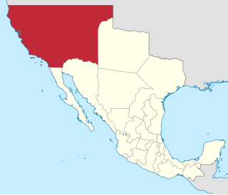
Alta California, also known as Nueva California, among other names, was a province of New Spain, formally established in 1804. Along with the Baja California peninsula, it had previously comprised the province of Las Californias, but was split off into a separate province in 1804. Following the Mexican War of Independence, it became a territory of Mexico in April 1822 and was renamed "Alta California" in 1824. The claimed territory included all of the modern US states of California, Nevada and Utah, and parts of Arizona, Wyoming, Colorado and New Mexico. In the 1836 Siete Leyes government reorganization, the two Californias were once again combined into a single departamento. That change was undone in 1846, but rendered moot by the U.S. military occupation of California in the Mexican-American War.
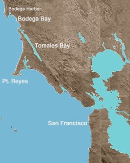
Bodega Bay is a shallow, rocky inlet of the Pacific Ocean on the coast of northern California in the United States. It is approximately 5 mi (8 km) across and is located approximately 40 mi (60 km) northwest of San Francisco and 20 mi (32 km) west of Santa Rosa. The bay straddles the boundary between Sonoma County to the north and Marin County to the south. The bay is a marine habitat used for navigation, recreation, and commercial and sport fishing.

Fort Ross, originally Fortress Ross, is a former Russian establishment on the west coast of North America in what is now Sonoma County, California. It was the hub of the southernmost Russian settlements in North America from 1812 to 1842. It has been the subject of archaeological investigation and is a California Historical Landmark, a National Historic Landmark, and on the National Register of Historic Places. It is part of California's Fort Ross State Historic Park.

Zzyzx, formerly Soda Springs, is an unincorporated community in San Bernardino County, California, within the boundaries of the Mojave National Preserve. It is the former site of the Zzyzx Mineral Springs and Health Spa and now the site of the Desert Studies Center. The site is also the location of Lake Tuendae, originally part of the spa, and now a refuge habitat of the endangered Mohave tui chub.

Kamala Devi Harris is an American lawyer and politician serving as the junior United States Senator from California since 2017. A member of the Democratic Party, Harris is the second African American woman and the first South Asian American to serve in the United States Senate.
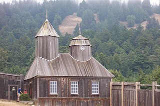
Fort Ross State Historic Park is a historical state park in Sonoma County, California, including the former Russian fur trading outpost of Fort Ross plus the adjacent coastline and native coast redwood forests extending inland. Fort Ross, active from 1812 to 1842, was the southernmost settlement in the Russian colonization of the Americas. The 3,393-acre (1,373 ha) park was established in 1909.

The Californias, occasionally known as the Three Californias or Two Californias, are a region of North America spanning the United States and Mexico, consisting of the U.S. state of California and the Mexican states of Baja California and Baja California Sur. Historically, the term Californias was used to define the vast northwestern region of Spanish America, as the Province of the Californias, and later as a collective term for Alta California and the Baja California Peninsula.
Bidwell is a former settlement in Butte County, California, United States. It was located 1.25 miles (2.0 km) west of Bidwell's Bar on the Western Pacific Railroad, and Feather River Railway at an elevation of 902 feet. The settlement was near the Bidwell-Sacramento River State Park, and has been inundated by Lake Oroville.
Hume is a former settlement in Butte County, California. It was located 3.5 miles (5.6 km) east-northeast of Biggs on the now-abandoned Northern Electric Railroad (which became the Sacramento Northern, at an elevation of 112 feet. The settlement still appeared on maps as of 1912.
Butte Creek is a former settlement in Butte County, California, United States. It was located 4 miles (6.4 km) east-southeast of Chico on the Southern Pacific Railroad.
Colbys Landing is a former settlement in Butte County, California, United States. It was located 7 miles (11 km) northwest of Chico, California on the Sacramento River. The settlement served as a commerce transfer station from 1858 until 1870, when the railroad to Nord, California was completed.
Lippitt or Camp Lippitt is a former settlement and military post in Humboldt County, California. It was located near the settlement of Bucksport. Camp Lippet was named for Col. Francis J. Lippitt of the 2nd California Infantry and was in use for two months, in 1862. It was established to help alleviate the inadequacies at Fort Humboldt and consisted entirely of rented buildings in Bucksport, garrisoned by Company F, 2nd Regiment California Volunteer Infantry.

Sageland is an unincorporated community in Kern County, California. It is located near Kelso Creek 3.5 miles (5.6 km) west-northwest at the base of the Piute Mountains, at an elevation of 4,026 feet (1,227 m).
Barnes Settlement is a former settlement in Kern County, California. It was located a little west of Old River.
Rio Bravo is a former settlement in Kern County, California. It was located on the railroad 2 miles (3.2 km) north of Panama.
Girard was a settlement in Kern County, California. It was located on the railroad halfway between Tehachapi and Keene.
Alpine is a former settlement in Los Angeles County, California. It stood at an elevation of 1923 feet above sea level. Alpine still appeared on some maps as of 1933. Alpine once existed about five miles southwest of Palmdale, California, and about a mile from the Fin and Feather Club Lake.
Soledad Sulphur Springs is a former settlement in Los Angeles County, California. It lay at an elevation of 1811 feet. Soledad Sulphur Springs still appeared on USGS maps as of 1933. Today, the area is on Sand Canyon Road near the Metrolink Antelope Valley railroad line and California State Route 14 on the outskirts of Santa Clarita. This settlement gave its name to the Sulphur Springs School District.
Cucamonga is a former Tongva-Gabrieleño Native American settlement in Los Angeles County, California.

Hahamongna and Hahamog-na are historic Tongva-Gabrieleño Native American settlements in the Verdugo Mountains of Southern California, named after the local Tongva band's name Hahamog'na, in present-day Pasadena and Glendale in Los Angeles County, California.
References
- 1 2 Durham, David L. (1998). California's Geographic Names: A Gazetteer of Historic and Modern Names of the State. Clovis, Calif.: Word Dancer Press. p. 808. ISBN 1-884995-14-4.

| This Calaveras County, California–related article is a stub. You can help Wikipedia by expanding it. |