Hodson, California

Last updated

Coordinates: 37°59′48″N120°41′08″W / 37.99667°N 120.68556°W / 37.99667; -120.68556

Geographic coordinate system Coordinate system

A geographic coordinate system is a coordinate system that enables every location on Earth to be specified by a set of numbers, letters or symbols. The coordinates are often chosen such that one of the numbers represents a vertical position and two or three of the numbers represent a horizontal position; alternatively, a geographic position may be expressed in a combined three-dimensional Cartesian vector. A common choice of coordinates is latitude, longitude and elevation. To specify a location on a plane requires a map projection.

Hodson
Former settlement
USA California location map.svg
Red pog.svg
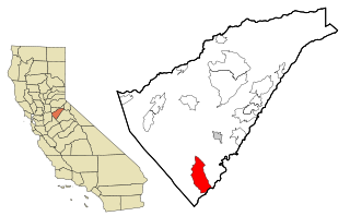
Hodson
Location in California
Coordinates: 37°59′48″N120°41′08″W / 37.99667°N 120.68556°W / 37.99667; -120.68556
Country United States
State California
County Calaveras County
Elevation [1] 971 ft (296 m)

Hodson is a former settlement in Calaveras County, California. It lay at an elevation of 971 feet (296 m), 2.5 miles (4.0 km) west-northwest of Copperopolis. [2] A post office operated at Hodson from 1898 to 1906, and again from 1915 to 1917. [2]

Calaveras County, California County in California

Calaveras County, officially the County of Calaveras, is a county in the northern portion of the U.S. state, California. As of the 2010 census, the population was 40,171. The county seat is San Andreas. Angels Camp is the only incorporated city in the county. Calaveras is the Spanish word for skulls; the county was reportedly named for the remains of Native Americans discovered by the Spanish explorer Captain Gabriel Moraga.

California State of the United States of America

California is a state in the Pacific Region of the United States. With 39.6 million residents, California is the most populous U.S. state and the third-largest by area. The state capital is Sacramento. The Greater Los Angeles Area and the San Francisco Bay Area are the nation's second and fifth most populous urban regions, with 18.7 million and 9.7 million residents respectively. Los Angeles is California's most populous city, and the country's second most populous, after New York City. California also has the nation's most populous county, Los Angeles County, and its largest county by area, San Bernardino County. The City and County of San Francisco is both the country's second-most densely populated major city after New York City and the fifth-most densely populated county, behind only four of the five New York City boroughs.

Copperopolis, California census-designated place in California, United States

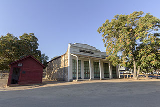
Copperopolis is a census-designated place (CDP) in Calaveras County, California, United States. The population was 3,671 at the 2010 census, up from 2,363 at the 2000 census. The town is located along State Route 4 and is registered as California Historical Landmark #296.

The town was named in honor of J.J. Hodson, a copper mining financier. [2]

Related Research Articles

The Shores of Poker Flat, California Unincorporated community in California, United States

The Shores of Poker Flat is an unincorporated community in Calaveras County, California. It lies at an elevation of 584 feet above sea level and is located at 37°54′11″N120°34′56″W, on the shore of the Tulloch Reservoir. The community is in ZIP code 95228 and area code 209.

Paloma, California Unincorporated community in California, United States

Paloma is an unincorporated community in Calaveras County, California. It lies at an elevation of 1362 feet and is located at 38°15′34″N120°45′48″W. The community is in ZIP code 95252 and area code 209.

Annisquam River

The Annisquam River is a tidal, salt-water estuary in Annisquam and Gloucester, Massachusetts, connecting Annisquam Harbor on the north to Gloucester Harbor on the south. The segment between Gloucester Harbor and the Newburyport/Rockport Line bridge is also known as the Blynman Canal.

La Grange, California Unincorporated community in California, United States

La Grange is a small unincorporated community in rural Stanislaus County, California, United States. Its altitude is 249 feet (76 m). As of 2008 it has a population of 345. It is located at 37°39′49″N120°27′49″W along the Tuolumne River, and is near the La Grange Dam and the New Don Pedro Dam.

Bald Mountain (California) name given to over fifty summits in California

Bald Mountain is a name given to over fifty summits in California.

Pacific, California Unincorporated community in California, United States

Pacific is a small unincorporated community in El Dorado County, California. It is located 3.25 miles (5 km) east of Pollock Pines, at an elevation of 3396 feet. It lies along U.S. Highway 50 and is next to the town of Pacific House, California. The ZIP code is 95726. The community is inside area code 530.

Hershey, California Unincorporated community in California, United States

Hershey is an unincorporated community in Colusa and Yolo counties in the U.S. state of California. It is located on the Southern Pacific Railroad 3.25 miles (5.2 km) north-northwest of Dunnigan, at an elevation of 141 feet. It is named after Yolo County's first assemblyman, David N. Hershey.

Allen, California Unincorporated community in California, United States

Allen is an unincorporated community in Amador County, California. It is located on the Bear River, at an elevation of 8,113 feet.

Pine Acres, California Unincorporated community in California, United States

Pine Acres is an unincorporated community in Amador County, California. It lies at an elevation of 2684 feet.

Ranch House Estates, California Unincorporated community in California, United States

Ranch House Estates is an unincorporated community in Amador County, California. It lies at an elevation of 2546 feet.

Sunnybrook, California Unincorporated community in California, United States

Sunnybrook is an unincorporated community in Amador County, California. It is located on Mountain Spring Creek 3 miles (4.8 km) east of Ione. It lies at an elevation of 784 feet.

Copper Cove Village, California Unincorporated community in California, United States

Copper Cove Village is an unincorporated community in Calaveras County, California. It lies at an elevation of 873 feet.

Mountain Retreat, California Unincorporated community in California, United States

Mountain Retreat is an unincorporated community in Calaveras County, California. It lies at an elevation of 4052 feet.

Rich Gulch, California Unincorporated community in California, United States

Rich Gulch is an unincorporated community in Calaveras County, California, 5 miles (8.0 km) east-northeast of Mokelumne Hill. It lies at an elevation of 1903 feet.

Telegraph City, California Unincorporated community in California, United States

Telegraph City is an unincorporated community in Calaveras County, California. It lies at an elevation of 653 feet. A post office operated here from 1862 to 1894. The place was named for its location on the telegraph line between Stockton and Sonora.

Avinsino Corner, California Unincorporated community in California, United States

Avinsino Corner is an unincorporated community in El Dorado County, California. It is located 3 miles (4.8 km) south of Camino, at an elevation of 2484 feet.

Pomins, California Unincorporated community in California, United States

Pomins is an unincorporated community in El Dorado County, California. It is located 2 miles (3.2 km) north of Meeks Bay, at an elevation of 6260 feet.

Fairview, Rush County, Indiana Unincorporated community in Indiana, United States

Fairview is an unincorporated community in Rush and Fayette counties, in the U.S. state of Indiana.

Tercio is an extinct town in Las Animas County, in the U.S. state of Colorado. The GNIS classifies it as a populated place.

Table Rock is an unincorporated area in northwestern Phelps County, in the U.S. state of Missouri. The community is located on the west bank of the Gasconade River, approximately 2.5 miles north of Jerome.

References

  1. U.S. Geological Survey Geographic Names Information System: Hodson, California
  2. 1 2 3 Durham, David L. (1998). California's Geographic Names: A Gazetteer of Historic and Modern Names of the State. Clovis, Calif.: Word Dancer Press. p. 783. ISBN   1-884995-14-4.