Mountain Ranch, California

Last updated

Mountain Ranch
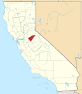
Calaveras County California Incorporated and Unincorporated areas Mountain Ranch Highlighted.svg
Location in Calaveras County and the state of California
Usa edcp location map.svg
Red pog.svg
Mountain Ranch
Location in the United States
Coordinates: 38°13′42″N120°32′27″W / 38.22833°N 120.54083°W / 38.22833; -120.54083
Country Flag of the United States (23px).png  United States
State Flag of California.svg  California
County Calaveras
Area
[1]
  Total41.244 sq mi (106.822 km2)
  Land41.188 sq mi (106.677 km2)
  Water0.056 sq mi (0.145 km2)  0.14%
Elevation
[2]
2,123 ft (647 m)
Population
 (2010)
  Total1,628
  Density37.7/sq mi (14.6/km2)
Time zone UTC-8 (Pacific (PST))
  Summer (DST) UTC-7 (PDT)
ZIP code
95246
Area code 209
FIPS code 06-49628
GNIS feature IDs 229196, 2408882
Official nameEl Dorado [3]
Reference no.282

Mountain Ranch (formerly, El Dorado and El Dorado Town) is a census-designated place (CDP) in Calaveras County, California, United States. The population was 1,628 at the 2010 census, up from 1,557 at the 2000 census. The town is registered as California Historical Landmark #282. [3] The town center is quite small with fewer than 50 people living in it. The 5 mile square area surrounding the town accounts for the balance of the population.

Contents

History

The settlement was established during the California Gold Rush. [4] Mountain Ranch's post office was established in 1858. [5] In 1868, it was moved to another town called El Dorado Camp 1.5 miles south, as there was already an El Dorado post office in California, El Dorado Camp became known as Mountain Ranch. Currently, there are 3 post office buildings in the town. The present one, a small post office which was built in 1956, and a post office built in 1923 which was once billed as the world's smallest post office. The original location of the town of Mountain Ranch also has a historical landmark. The bell on the historical marker was used in the local school from 1885 to 1953. Established as Cave City School District in 1855, this school joined with the Banner District in 1946 to become the El Dorado Union Elementary School District. In 1942 the last of the gold mines closed. [4] Further economic losses took place in the 1970s, when local saw mills shuttered, and also in 1983 when the Calaveras Cement Co. closed. [4] In 2015, the town was ravaged by the Butte Fire. More than 350 homes [4] along the outskirts burned, but firefighters and local ranchers were able to save most of the downtown.

Geography

According to the United States Census Bureau, the CDP has a total area of 41.2 square miles (107 km2), of which 99.86% is land, and 0.14% is water.

Demographics

At the 2010 census Mountain Ranch had a population of 1,628. The population density was 39.5 inhabitants per square mile (15.3/km2). The racial makeup of Mountain Ranch was 1,472 (90.4%) White, 15 (0.9%) African American, 33 (2.0%) Native American, 18 (1.1%) Asian, 2 (0.1%) Pacific Islander, 15 (0.9%) from other races, and 73 (4.5%) from two or more races. Hispanic or Latino of any race were 123 people (7.6%). [6]

The whole population lived in households, no one lived in non-institutionalized group quarters and no one was institutionalized.

There were 748 households, 113 (15.1%) had children under the age of 18 living in them, 410 (54.8%) were opposite-sex married couples living together, 53 (7.1%) had a female householder with no husband present, 23 (3.1%) had a male householder with no wife present. There were 50 (6.7%) unmarried opposite-sex partnerships, and 5 (0.7%) same-sex married couples or partnerships. 211 households (28.2%) were one person and 89 (11.9%) had someone living alone who was 65 or older. The average household size was 2.18. There were 486 families (65.0% of households); the average family size was 2.60.

The age distribution was 213 people (13.1%) under the age of 18, 86 people (5.3%) aged 18 to 24, 201 people (12.3%) aged 25 to 44, 712 people (43.7%) aged 45 to 64, and 416 people (25.6%) who were 65 or older. The median age was 55.3 years. For every 100 females, there were 105.8 males. For every 100 females age 18 and over, there were 106.3 males.

There were 960 housing units at an average density of 23.3 per square mile (9.0/km2),of which 748 were occupied, 620 (82.9%) by the owners and 128 (17.1%) by renters. The homeowner vacancy rate was 2.8%; the rental vacancy rate was 9.8%. 1,352 people (83.0% of the population) lived in owner-occupied housing units and 276 people (17.0%) lived in rental housing units.

Politics

In the state legislature, Mountain Ranch is in the 8th Senate District , represented by Democrat Angelique Ashby, [7] and the 5th Assembly District , represented by Republican Joe Patterson. [8] Federally, Mountain Ranch is in California's 4th congressional district , represented by Democrat Mike Thompson. [9]

Notable natives

Related Research Articles

<span class="mw-page-title-main">Sunol, California</span> Census-designated place in California, United States

Sunol is an unincorporated area and census-designated place in Alameda County, California. Located in the Sunol Valley of the East Bay, the population was 913 at the 2010 census. It is best known as the location of the Sunol Water Temple and for its historic tourist railroad system, the Niles Canyon Railway.

<span class="mw-page-title-main">Kirkwood, California</span> Place in California, United States

Kirkwood is an unincorporated community in Alpine and Amador counties, California, United States. Kirkwood's main attraction is the Kirkwood Mountain Resort. The town is accessible by State Route 88. Kirkwood is within the Eldorado National Forest. The population was 158 at the 2010 census. For statistical purposes, the United States Census Bureau has defined Kirkwood as a census-designated place (CDP).

<span class="mw-page-title-main">Arnold, California</span> Census-designated place in Calaveras County, California, United States

Arnold is a census-designated place (CDP) in Calaveras County, California, United States. The population was 3,843 at the 2010 census, down from 4,218 at the 2000 census. Arnold is located on State Route 4.

<span class="mw-page-title-main">Copperopolis, California</span> Census-designated place in California, United States

Copperopolis is an unincorporated town and census-designated place (CDP) in Calaveras County, California, United States. The population was 3,671 at the 2010 census, up from 2,363 at the 2000 census. The town is located along State Route 4 and is registered as California Historical Landmark #296.

<span class="mw-page-title-main">Dorrington, California</span> Census-designated place in California, United States

Dorrington is a census-designated place (CDP) in Calaveras County, California, United States. The population was 609 at the 2010 census, down from 727 at the 2000 census. Originally known as Cold Spring Ranch until 1902, the town sits on State Route 4 and historically was a stopping point along the toll road between Murphys and Ebbetts Pass, often serving as a resort for visitors to what is now Calaveras Big Trees State Park. Dorrington is also home to the second largest Sugar Pine in the world, measuring 32 feet in circumference and 220 feet tall. The name Dorrington comes from the maiden name of Rebecca (Dorrington) Gardner.

<span class="mw-page-title-main">Murphys, California</span> Census designated place in California, United States

Murphys, originally Murphys New Diggings then Murphy's Camp, is an unincorporated village located in the foothills of the Sierra Nevada mountains in Calaveras County, California, United States. The population was 2,213 at the 2010 census, up from 2,061 at the 2000 census.

<span class="mw-page-title-main">Rail Road Flat, California</span> Census-designated place in California, United States

Rail Road Flat is a census-designated place (CDP) in Calaveras County, California, United States. The population was 475 at the 2010 census, down from 549 at the 2000 census.

<span class="mw-page-title-main">San Andreas, California</span> Census-designated place in California, United States

San Andreas is an unincorporated census-designated place and the county seat of Calaveras County, California. The population was 2,783 at the 2010 census, up from 2,615 at the 2000 census. Like most towns in the region, it was founded during the California Gold Rush. The town is located on State Route 49 and is registered as California Historical Landmark #252.

<span class="mw-page-title-main">Vallecito, California</span> Census-designated place in California, United States

Vallecito is a census-designated place (CDP) in Calaveras County, California, United States. The population was 442 at the 2010 census, up from 427 at the 2000 census. The town is registered as California Historical Landmark #273. Nearby is Moaning Cavern, the largest cave chamber in California, which the Miwok Indians used as a burial ground.

<span class="mw-page-title-main">Wallace, California</span> Census-designated place in California, United States

Wallace is a census-designated place (CDP) at the far west edge of Calaveras County, California, United States on State Route 12. The population was 403 at the 2010 census, up from 220 at the 2000 census.

<span class="mw-page-title-main">Cameron Park, California</span> CDP in California, United States

Cameron Park is a census-designated place (CDP) in El Dorado County, California, United States and is part of the Greater Sacramento Area. The population was 19,171 in the 2020 census, up from 18,228 in 2010. Cameron Park is a community located in the Northern California Gold Country of the Sierra Nevada foothills, approximately 30 miles (50 km) east of Sacramento and 70 miles (110 km) west of South Lake Tahoe.

<span class="mw-page-title-main">Diamond Springs, California</span> Census-designated place in California, United States

Diamond Springs is a census-designated place (CDP) in El Dorado County, California, United States. It is part of the Sacramento–Arden-Arcade–Roseville Metropolitan Statistical Area. The population was 11,037 at the 2010 census, up from 4,888 at the 2000 census. The town is registered as California Historical Landmark number 487. It lies at an elevation of 1791 feet.

<span class="mw-page-title-main">El Dorado Hills, California</span> Census-designated place in California, United States

El Dorado Hills is an unincorporated town and census-designated place in El Dorado County, California. Located in the Greater Sacramento region of Northern California, it had a population of 50,547 at the 2020 census, up from 42,108 at the 2010 census.

<span class="mw-page-title-main">Georgetown, California</span> Census-designated place in California, United States

Georgetown is a census-designated place (CDP) in El Dorado County, California, United States. It is the northeasternmost town in the California Mother Lode. The population was 2,367 at the 2010 census, up from 962 in 2000. The town is registered as California Historical Landmark #484.

<span class="mw-page-title-main">Pollock Pines, California</span> Census-designated place in California, United States

Pollock Pines is a census-designated place (CDP) in El Dorado County, California, United States. It is part of the Sacramento–Arden-Arcade–Roseville Metropolitan Statistical Area. Pollock Pines lies at an elevation of 3,980 feet (1,210 m) in the Sierra Nevada. The population was 7,112 at the 2020 census, up from 6,871 at the 2010 census.

<span class="mw-page-title-main">Shingle Springs, California</span> Census-designated place in California, United States

Shingle Springs is a census-designated place (CDP) in El Dorado County, California, United States. The population was 4,432 at the 2010 census, up from 2,643 at the 2000 census. It is located about 40 miles (64 km) from Sacramento in the Gold Country foothills and sits directly on Highway 50. The towns of Coloma and Placerville are less than 15 miles (24 km) away.

<span class="mw-page-title-main">Coloma, California</span> Census-designated place in California, United States

Coloma is a census-designated place in El Dorado County, California, US. It is approximately 36 miles (58 km) northeast of Sacramento, California. Coloma is most noted for being the site where James W. Marshall found gold in the Sierra Nevada foothills, at Sutter's Mill on January 24, 1848, leading to the California Gold Rush. Coloma's population is 529.

<span class="mw-page-title-main">Camino, California</span> Census-designated place in California, United States

Camino is a census-designated place in El Dorado County, California, and, per the 2010 census, has a population of 1,750. According to the USGS, it lies at an elevation of 3133 feet, but the elevation actually ranges between 3,000 and 3,500 feet. Being well more than half a mile above sea level, it snows several times per year in the community. Nearby cities and towns include Pollock Pines, Placerville, Diamond Springs, El Dorado, Grizzly Flats, Somerset, Coloma, Garden Valley, Cameron Park, Shingle Springs, and Lotus.

<span class="mw-page-title-main">Grizzly Flats, California</span> Census-designated place in California, United States

Grizzly Flats is a census-designated place in El Dorado County, California. It is located southeast of Camino, at an elevation of 3868 feet (1179 m). Grizzly Flats is the town nearest to Baltic Peak, a small peak to the northwest. The population at the 2010 census was 1,066.

<span class="mw-page-title-main">Gold Mountain, California</span> Unincorporated community in the United States

Gold Mountain is an unincorporated community in Plumas County, California. Gold Mountain sits at an elevation of 5,341 feet (1,628 m). The 2010 United States census reported Gold Mountain's population was 80. For statistical purposes, the United States Census Bureau has defined Gold Mountain as a census-designated place (CDP).

References

  1. "2010 Census U.S. Gazetteer Files – Places – California". United States Census Bureau.
  2. "Mountain Ranch". Geographic Names Information System . United States Geological Survey, United States Department of the Interior . Retrieved April 18, 2015.
  3. 1 2 "El Dorado". Office of Historic Preservation, California State Parks. Retrieved October 6, 2012.
  4. 1 2 3 4 "Northern California Town Fights Back After Being Nearly Burned Off Map". Insurance Journal. September 28, 2015. Retrieved September 29, 2015.
  5. Durham, David L. (1998). California's Geographic Names: A Gazetteer of Historic and Modern Names of the State. Clovis, Calif.: Word Dancer Press. p. 806. ISBN   1-884995-14-4.
  6. "2010 Census Interactive Population Search: CA - Mountain Ranch CDP". U.S. Census Bureau. Archived from the original on July 15, 2014. Retrieved July 12, 2014.
  7. "Senators". State of California. Retrieved March 21, 2013.
  8. "Members Assembly". State of California. Retrieved March 21, 2013.
  9. "California's 4th Congressional District - Representatives & District Map". Civic Impulse, LLC. Retrieved March 2, 2013.