Rancho Calaveras | |
---|---|
Coordinates: 38°07′39″N120°51′30″W / 38.12750°N 120.85833°W | |
Country | United States |
State | California |
County | Calaveras |
Area | |
• Total | 8.406 sq mi (21.770 km2) |
• Land | 8.376 sq mi (21.693 km2) |
• Water | 0.030 sq mi (0.077 km2) 0.35% |
Elevation | 528 ft (161 m) |
Population (2010) | |
• Total | 5,324 |
• Density | 630/sq mi (240/km2) |
Time zone | UTC-8 (Pacific (PST)) |
• Summer (DST) | UTC-7 (PDT) |
ZIP code | 95252 |
Area code | 209 |
FIPS code | 06-59426 |
GNIS feature IDs | 1804851, 2409134 |
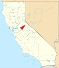
Rancho Calaveras is a census-designated place (CDP) in Calaveras County, California, United States. The population was 5,325 at the 2010 census, up from 4,182 at the 2000 census.
According to the United States Census Bureau, the CDP has a total area of 8.4 square miles (22 km2), of which 99.65% of it is land, and 0.35% is water.
Rancho Calaveras has a hot-summer Mediterranean climate (Köppen Csa) typical of the Sierra Nevada foothills. Winters are cool and wet with mild days, chilly nights, and substantial rainfall. Summers are hot and dry with very hot days, cool nights, and minimal rainfall. Due to the orographic effect, rainfall in all seasons is significantly greater than on the valley floor to the west.
Climate data for Rancho Calaveras (Valley Springs) | |||||||||||||
---|---|---|---|---|---|---|---|---|---|---|---|---|---|
Month | Jan | Feb | Mar | Apr | May | Jun | Jul | Aug | Sep | Oct | Nov | Dec | Year |
Average high °F (°C) | 53 (12) | 59 (15) | 63 (17) | 69 (21) | 79 (26) | 88 (31) | 94 (34) | 93 (34) | 88 (31) | 77 (25) | 62 (17) | 53 (12) | 73.2 (22.9) |
Daily mean °F (°C) | 46.0 (7.8) | 50.5 (10.3) | 53.5 (11.9) | 58.0 (14.4) | 65.5 (18.6) | 72.5 (22.5) | 76.9 (24.9) | 78.0 (25.6) | 73.5 (23.1) | 65.0 (18.3) | 53.5 (11.9) | 46.0 (7.8) | 61.6 (16.4) |
Average low °F (°C) | 39 (4) | 42 (6) | 44 (7) | 47 (8) | 52 (11) | 57 (14) | 62 (17) | 62 (17) | 59 (15) | 53 (12) | 45 (7) | 39 (4) | 50.1 (10.1) |
Average precipitation inches (mm) | 4.13 (105) | 3.86 (98) | 3.82 (97) | 2.01 (51) | 1.18 (30) | 0.28 (7.1) | 0 (0) | 0.04 (1.0) | 0.43 (11) | 1.3 (33) | 2.68 (68) | 3.74 (95) | 23.47 (596) |
Source: [2] |
The 2010 United States Census [3] reported that Rancho Calaveras had a population of 5,325. The population density was 633.5 inhabitants per square mile (244.6/km2). The racial makeup of Rancho Calaveras was 4,645 (87.2%) White, 48 (0.9%) African American, 102 (1.9%) Native American, 87 (1.6%) Asian, 13 (0.2%) Pacific Islander, 195 (3.7%) from other races, and 235 (4.4%) from two or more races. Hispanic or Latino of any race were 670 persons (12.6%).
The Census reported that 5,316 people (99.8% of the population) lived in households, 9 (0.2%) lived in non-institutionalized group quarters, and 0 (0%) were institutionalized.
There were 1,937 households, out of which 680 (35.1%) had children under the age of 18 living in them, 1,275 (65.8%) were opposite-sex married couples living together, 162 (8.4%) had a female householder with no spouse present, 98 (5.1%) had a male householder with no spouse present. There were 110 (5.7%) unmarried opposite-sex partnerships, and 18 (0.9%) same-sex married couples or partnerships. 301 households (15.5%) were made up of individuals, and 107 (5.5%) had someone living alone who was 65 years of age or older. The average household size was 2.74. There were 1,535 families (79.2% of all households); the average family size was 3.03.
The population was spread out, with 1,287 people (24.2%) under the age of 18, 337 people (6.3%) aged 18 to 24, 1,148 people (21.6%) aged 25 to 44, 1,845 people (34.6%) aged 45 to 64, and 708 people (13.3%) who were 65 years of age or older. The median age was 43.6 years. For every 100 females, there were 101.2 males. For every 100 females age 18 and over, there were 100.9 males.
There were 2,147 housing units at an average density of 255.4 per square mile (98.6/km2), of which 1,937 were occupied, of which 1,695 (87.5%) were owner-occupied, and 242 (12.5%) were occupied by renters. The homeowner vacancy rate was 3.9%; the rental vacancy rate was 8.2%. 4,519 people (84.9% of the population) lived in owner-occupied housing units and 797 people (15.0%) lived in rental housing units.
As of the census [4] of 2000, there were 4,182 people, 1,470 households, and 1,221 families residing in the CDP. The population density was 494.4 inhabitants per square mile (190.9/km2). There were 1,561 housing units at an average density of 184.5 per square mile (71.2/km2). The racial makeup of the CDP was 89.02% White, 0.86% Black or African American, 1.24% Native American, 1.48% Asian, 0.12% Pacific Islander, 2.80% from other races, and 4.47% from two or more races. 10.14% of the population were Hispanic or Latino of any race.
There were 1,470 households, out of which 38.6% had children under the age of 18 living with them, 71.4% were married couples living together, 7.0% had a female householder with no spouse present, and 16.9% were non-families. 12.9% of all households were made up of individuals, and 4.0% had someone living alone who was 65 years of age or older. The average household size was 2.84 and the average family size was 3.09.
In the CDP, the population was spread out, with 28.3% under the age of 18, 5.5% from 18 to 24, 26.9% from 25 to 44, 28.5% from 45 to 64, and 10.9% who were 65 years of age or older. The median age was 40 years. For every 100 females, there were 98.3 males. For every 100 females age 18 and over, there were 101.1 males.
The median income for a household in the CDP was $50,247, and the median income for a family was $53,017. Males had a median income of $50,614 versus $31,280 for females. The per capita income for the CDP was $21,444. About 3.5% of families and 5.8% of the population were below the poverty line, including 8.4% of those under age 18 and 2.2% of those age 65 or over.
In the state legislature, Rancho Calaveras is in the 8th Senate District , represented by Democrat Angelique Ashby, [5] and the 5th Assembly District , represented by Republican Joe Patterson, [6] Federally, Rancho Calaveras is in California's 4th congressional district , represented by Democrat Mike Thompson. [7]
Locally, Rancho Calaveras is represented by Calaveras County Supervisor Darren Spellman who won election November 2, 2010 with 60.1% of Rancho Calaveras voter approval.
Sunol is an unincorporated area and census-designated place in Alameda County, California. Located in the Sunol Valley of the East Bay, the population was 913 at the 2010 census. It is best known as the location of the Sunol Water Temple and for its historic tourist railroad system, the Niles Canyon Railway.
Bear Valley is a census-designated place in Alpine County, California, best known as the location of the Bear Valley ski area. The population was 121 at the 2010 census, down from 133 at the 2000 census.
Rail Road Flat is a census-designated place (CDP) in Calaveras County, California, United States. The population was 475 at the 2010 census, down from 549 at the 2000 census.
Vallecito is a census-designated place (CDP) in Calaveras County, California, United States. The population was 442 at the 2010 census, up from 427 at the 2000 census. The town is registered as California Historical Landmark #273. Nearby is Moaning Cavern, the largest cave chamber in California, which the Miwok Indians used as a burial ground.
Wallace is a census-designated place (CDP) at the far west edge of Calaveras County, California, United States on State Route 12. The population was 403 at the 2010 census, up from 220 at the 2000 census.
West Point is a census-designated place (CDP) in Calaveras County, California, in the United States. As of the 2010 United States Census, West Point's population was 674, down from 746 as of the 2000 census. The town is registered as California Historical Landmark #268. There is an annual West Point Lumberjack Days festival in the community.
Del Rey is a census-designated place (CDP) in Fresno County, California, United States. The population was 1,639 at the 2010 census, up from 950 at the 2000 census. Del Rey is located 3.5 miles (5.6 km) south-southwest of Sanger, at an elevation of 344.
Lanare is a community and census-designated place (CDP) in Fresno County, California, United States. The population was 589 at the 2010 census, up from 540 at the 2000 census. Lanare is located 24 miles (39 km) south-southwest of Fresno, at an elevation of 207 feet. The name is derived from Llewellyn A. Nares, the community developer. Lanare is currently served by the Riverdale Post Office, zip code 93656, and students attend public school in Riverdale.
East Rancho Dominguez, also known as East Compton, is an unincorporated community and census-designated place (CDP) located in southern Los Angeles County, California. The population was 15,135 at the 2010 census, up from 9,286 at the 2000 census. East Rancho Dominguez is an accepted city name according to the USPS, and shares the 90221 ZIP Code with Compton.
West Rancho Dominguez, formerly known as West Compton, is an unincorporated census-designated place (CDP) located in southern Los Angeles County, California. Per the 2020 census, the population was 24,347. The community lies to the west of the city of Compton. The ZIP Codes encompassing the CDP area are 90220 & 90248.
West Whittier-Los Nietos is a census-designated place (CDP) in Los Angeles County, California, near the San Gabriel River and the San Gabriel River (I-605) Freeway. The population was 25,540 at the 2010 census, up from 25,129 at the 2000 census. The census area consists of separate unincorporated communities of Los Nietos and West Whittier.
San Lucas is an unincorporated community and census-designated place (CDP) in Monterey County, California, United States. It was founded in 1886 and named after the Rancho San Lucas, which was granted in 1842. The post office was first established in 1892.
Las Flores is an unincorporated census-designated place (CDP) in Orange County, California, located adjacent to the City of Rancho Santa Margarita, California. The population was 5,971 at the 2010 census, up from 5,625 at the 2000 census. Las Flores does not have its own ZIP Code and is served by the same ZIP Code as adjacent Rancho Santa Margarita. The Rancho Santa Margarita dog/skate park is located in the CDP and is served by the Orange County Sheriff's Dept. and Orange County Fire Authority.
Keddie is a census-designated place in Plumas County, California, United States. The population was 66 at the 2010 census.
Rancho Murieta is a census-designated place (CDP) and guard-gated community in Sacramento County, California, United States. It is part of the Sacramento–Arden-Arcade–Roseville Metropolitan Statistical Area. The population was 5,488 at the 2010 census, up from 4,193 at the 2000 census. It is located in the foothills of the Sierra Nevada range, about 25 miles (40 km) east of Sacramento.
Lake San Marcos is a census-designated place (CDP) in the North County region of the San Diego metropolitan area. It is nominally independent of San Marcos proper, but functionally subservient to the city.
Eldridge is a census-designated place (CDP) in Sonoma County, California, United States. The population was 1,233 at the 2010 census. It is notably the home to the Sonoma Developmental Center, the largest facility serving the needs of persons with developmental disabilities in the state.
Rancho San Diego is a census-designated place (CDP) in the East County region of San Diego County, California. The population was 21,858 at the 2020 census, up from 21,208 at the 2010 census. The area was developed as subdivisions beginning in the 1970s.
Gardnerville Ranchos is a census-designated place in Douglas County, Nevada, United States. As of the 2010 census, the population was 11,312. The area is the namesake for the Gardnerville Ranchos Micropolitan Statistical area which includes other areas of Douglas County.
El Rancho is a census-designated place (CDP) in Tulare County, California. El Rancho sits at an elevation of 390 feet (120 m). The 2010 United States census reported El Rancho's population was 124.