Related Research Articles

Plumas County is a county in the Sierra Nevada of California, United States. As of the 2010 census, the population was 20,007. The county seat is Quincy, and the only incorporated city is Portola. The largest community in the county is East Quincy. The county was named for the Spanish Río de las Plumas, which flows through the county.

Beckwourth is a census-designated place (CDP) in Plumas County, California, United States. Beckwourth is located on the Middle Fork Feather River 5 miles (8.0 km) east of Portola. The population was 432 at the 2010 census, up from 342 at the 2000 census.

Graeagle is a census-designated place (CDP) located about 60 miles (97 km) from Reno, Nevada and 46 miles (74 km) from Truckee, California in Plumas County, California, United States. The population was 737 at the 2010 census, down from 831 at the 2000 census.

La Porte is a census-designated place (CDP) in Plumas County, California, United States. The population was 26 at the 2010 census, down from 43 at the 2000 census.
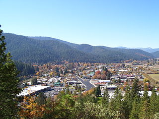
Quincy is a census-designated place and the county seat of Plumas County, California. The population was 1,728 during the 2010 census, down from 1,879 during the 2000 United States Census.

The Feather River is the principal tributary of the Sacramento River, in the Sacramento Valley of Northern California. The river's main stem is about 73 miles (117 km) long. Its length to its most distant headwater tributary is just over 210 miles (340 km). The main stem Feather River begins in Lake Oroville, where its four long tributary forks join together—the South Fork, Middle Fork, North Fork, and West Branch Feather Rivers. These and other tributaries drain part of the northern Sierra Nevada, and the extreme southern Cascades, as well as a small portion of the Sacramento Valley. The total drainage basin is about 6,200 square miles (16,000 km2), with approximately 3,604 square miles (9,330 km2) above Lake Oroville.

The Shores of Poker Flat is an unincorporated community in Calaveras County, California. It lies at an elevation of 584 feet above sea level and is located at 37°54′11″N120°34′56″W, on the shore of the Tulloch Reservoir. The community is in ZIP code 95228 and area code 209.
Sierra Valley is a large mountain valley located east of the crest of California's Sierra Nevada mountain range in Plumas and Sierra Counties, north of Interstate 80.

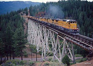
The Williams Loop is a rail spiral located on the Union Pacific Railroad's Feather River Route through the Sierra Nevada mountains in northeastern California, connecting the Sacramento Valley to Salt Lake City via the Feather River canyons. Located approximately five miles east of East Quincy, the loop is used to gain elevation on the WP's eastward climb to its summit at Beckwourth Pass while maintaining the railroad's overall 1.0 percent (compensated) grade, the least steep of any grade on a transcontinental railroad. More specifically, the loop helps the railroad to surmount the divide between the East Branch North Fork Feather River and the Middle Fork Feather River.
Merrimac was an unincorporated community in Butte County, California located along Oroville-Quincy Road about 2.1 miles (3.4 km) south of the Plumas County line at an elevation of 3999 feet. Nearby is Rogers Cow Camp, a campground in Lassen National Forest.
The Elephants Playground is a rock formation located in Genesee, Plumas County, California. The area burned in the 2019 Walker Fire.
Happy Valley is an area in Plumas County, California, United States, is located in Grizzly Valley.
Eagleville is an unincorporated community in Yuba County, California. Eagleville is 1.25 miles (2.0 km) north-northeast of Strawberry Valley. The community is in a rural area near the intersection of Yuba, Butte, and Plumas County lines. There is no post office. Elevation above mean sea level was listed as 3,757 feet (1,145 m). As of 2013, 73,340 people lived in the area.
Plumas Lake is an unincorporated community in Yuba County, California. It is located on the Western Pacific Railroad 2.5 miles (4.0 km) south of Olivehurst, at an elevation of 56 feet.
The Clio Trestle is a railroad trestle on the historic Feather River Route of the Union Pacific Railroad. It is located in the Sierra Nevada near Clio in Plumas County, California. The trestle is 172 feet (52 m) high and 1,005 feet (306 m) long.
The Spring Garden Tunnel at 7,344 ft (2,238 m) in Spring Garden, California is the longest of 34 tunnels on the Feather River Route and crosses under the drainage divide between the East Branch North Fork Feather River and the Middle Fork Feather River.

Las Plumas is a former settlement in Butte County, California.
Plumas is a former settlement in Yuba County, California. It was located 1.25 miles (2.0 km) south-southeast of Arboga on the Sacramento Northern Railroad.
Plumas Landing is a former settlement in Yuba County, California. It was located on Feather River, 9 miles (14 km) south of Marysville.
The Nakoma Resort is a golf resort in Mohawk Valley of Plumas County, California.
References
- ↑ Durham, David L. (1998). California's Geographic Names: A Gazetteer of Historic and Modern Names of the State. Clovis, Calif.: Word Dancer Press. p. 788. ISBN 1-884995-14-4.

Coordinates: 39°43′02″N120°33′24″W / 39.7171223°N 120.5566049°W
| This Plumas County, California-related article is a stub. You can help Wikipedia by expanding it. |