Amalfi is a town and comune in the province of Salerno, in the region of Campania, Italy, on the Gulf of Salerno. It lies at the mouth of a deep ravine, at the foot of Monte Cerreto, surrounded by dramatic cliffs and coastal scenery. The town of Amalfi was the capital of the maritime republic known as the Duchy of Amalfi, an important trading power in the Mediterranean between 839 and around 1200.

Positano is a village and comune on the Amalfi Coast, in Campania, Italy, mainly in an enclave in the hills leading down to the coast.

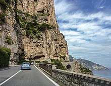
The Amalfi Coast is a stretch of coastline in southern Italy overlooking the Tyrrhenian Sea and the Gulf of Salerno. It is located south of the Sorrentine Peninsula and north of the Cilentan Coast.

Praiano is a town and comune of the province of Salerno in the Campania region of southwest Italy. It is situated on the Amalfi Coast, a prime tourist location for the region and Italy alike, between the towns of Amalfi and Positano.

The Autostrada A18 is an autostrada 77 kilometres (48 mi) long in Italy on the Ionian coast of Sicily that links Messina to Catania. The motorway is linked to the A20 Messina-Palermo at its northern end and to the A19 Palermo-Catania through the RA15 Catania's Ring Road at its southern end. There is also a second stretch of the Autostrada A18, 59.1 kilometres (36.7 mi) long, on the south part of the island, running from Syracuse to Modica, and with the plan to extend it to Gela. It is a part of the E45 European route.

The Autostrada A91, also called Autostrada Roma-Fiumicino, is an autostrada 18.5 kilometres (11.5 mi) long in Italy located in the region of Lazio which connects Rome to the Leonardo da Vinci–Fiumicino Airport in Fiumicino. It is a part of the E80 European route.

The Strada statale 131 Diramazione Centrale Nuorese is an Italian state highway 144.0 kilometres (89.5 mi) long in Italy located in the region of Sardinia. This freeway is connected to the Strada statale 131 Carlo Felice, it links Abbasanta with Olbia, via Nuoro, crossing the hinterland mountainous regions of the island.
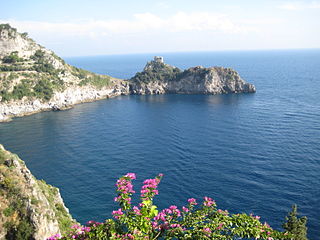
The Grotta dello Smeraldo is a cave, partly inundated by the sea and located in Conca dei Marini, Italy, on the Amalfi Coast.

The Strada statale 115 Sud Occidentale Sicula (SS115) is an Italian state highway 395.7 kilometres (245.9 mi) long in Italy located in the regions of Sicily. It is one of the major roads in Sicily. It is the major state highway running along the south coast and connects the towns of Trapani and Syracuse via Agrigento and Ragusa. It is a part of the European route E45 and European route E931.
The Strade Statali, abbreviated SS, are the Italian national network of state highways. The total length of the network is about 25,000 km (16,000 mi).

Strada statale 1 Via Aurelia is an Italian state highway 697.3 kilometres (433.3 mi) long in Italy located in the regions of Lazio, Tuscany and Liguria. It is one of the most important state highways in Italy and derives from an ancient Roman consular road, the Via Aurelia. It connects Rome with France following the coast of Tyrrhenian Sea and Ligurian Sea and touching nine provincial capitals as well as important tourist locations. It constitutes a section of the European route E80 from Tarquinia to Rosignano Marittimo

Strada statale 148 Pontina , previously known as Strada regionale 148 Pontina , is an Italian state highway 109.2 kilometres (67.9 mi) long in Italy in the region of Lazio that connects Rome to Terracina, passing through Latina and through the localities of Pomezia, Ardea in the Metropolitan City of Rome and for Aprilia, Pontinia and Sabaudia in province of Latina.

Strada statale 106 Jonica is an Italian state highway 491 kilometres (305 mi) long in Italy located in the regions of Apulia, Basilicata and Calabria which extends from Reggio Calabria to Taranto, covering the whole coast Jonica in Calabria, Basilicata and parts of Apulia. It constitutes a traffic route of national importance and is included in European route E90.

Raccordo autostradale 6 or Raccordo autostradale Bettolle-Perugia is an autostrada 59.3 kilometres (36.8 mi) long in Italy located in the regions of Tuscany and Umbria, and managed by ANAS, that allows a quick connection of the Strada statale 3 bis Tiberina near the city of Perugia with the Autostrada A1 where the route begins in the locality of Bettolle, municipality of Sinalunga. The RA 6 is a seamless continuation of the Strada statale 715 Siena-Bettolle and, on the other end, it continues as Strada statale 75 Centrale Umbra up to Foligno.

Strada statale 44 bis Passo del Rombo is an Italian state highway 29.51 kilometres (18.34 mi) long in Italy located in the region of Trentino-Alto Adige/Südtirol that connects Passiria with Austria.

Strada statale 44 del Passo di Giovo is an Italian state highway 57.829 kilometres (35.933 mi) long in Italy located in the region of Trentino-Alto Adige/Südtirol which connects Adige Valley with Isarco Valley passing through Passaria Valley.

Strada statale 48 delle Dolomiti, also known as strada regionale 48 delle Dolomiti is an Italian state highway 182.1 kilometres (113.2 mi) long in Italy located in the regions of Trentino-Alto Adige/Südtirol and Veneto. It is a mountainous road that runs through the Dolomites area from South Tyrol, through Trentino to Cadore, crossing very suggestive mountain scenery.

Strada statale 72 di San Marino is an Italian state highway 10.7 kilometres (6.6 mi) long in Italy located in the regions of Emilia-Romagna that connects the province of Rimini and connects the provincial capital with the Republic of San Marino. The current road, built after the World War II, is 10,600 km long and has a typically flat layout. It consists of two lanes in each direction of travel and replaces the old state road 72. The road begins on the outskirts of Rimini and ends at the Dogana state border. In San Marino, it continues as the San Marino Highway.

Strada statale 35 dei Giovi is an Italian state highway 172.8 kilometres (107.4 mi) long in Italy located in the regions of Liguria, Piedmont and Lombardy, which connects Genoa and the Italian Riviera with Como and the Canton of Ticino, passing through Pavia and Milan. The road begins in Genoa in the Sampierdarena district where it constitutes an important urban crossing artery with the Reti and Fillak streets, and then ends in Como more precisely at the Customs House in Ponte Chiasso on the border with Switzerland. Between Tortona and Casteggio the SS 35 is in common with the strada statale 10, while the Milan-Cermenate section is a Superstrada, built around the 1960s known as Superstrada Milano-Meda.

Strada statale 7 Via Appia is an Italian state highway 713.45 kilometres (443.32 mi) long in Italy located in the regions of Lazio, Campania, Basilicata and Apulia that follows the path of the ancient Appian Way, connecting Rome to Brindisi. In the stretch between Cisterna di Latina and Terracina, the SS 7 is called "fettuccia di Terracina" due to its straight line. It constitutes a section of the European route E90 from Taranto to Brindisi.