String Prairie, Texas | |
|---|---|
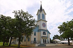 Saint Mary of the Assumption Church | |
 String Prairie  String Prairie | |
| Coordinates: 29°53′09″N97°20′49″W / 29.88583°N 97.34694°W | |
| Country | United States |
| State | Texas |
| County | Bastrop |
| Elevation | 505 ft (154 m) |
| Time zone | UTC-6 (Central (CST)) |
| • Summer (DST) | UTC-5 (CDT) |
| Area code(s) | 512 & 737 |
| GNIS feature ID | 1369285 [1] |
String Prairie is an unincorporated community in Bastrop County, Texas, United States. [1] According to the Handbook of Texas, the community had a population of 125 in 2000. It is located within the Greater Austin metropolitan area.
