Vermilion is a village in Stratton and Elbridge Township townships, Edgar County, Illinois, United States. The population was 203 at the 2020 census.

Sibley is a village in Ford County, Illinois, United States. The population was 288 at the 2020 census.

Beverly Township is one of twenty-two townships in Adams County, Illinois, USA. As of the 2020 census, its population was 354 and it contained 162 housing units.

Bloom Township is one of 29 townships in Cook County, Illinois, USA. As of the 2020 census, its population was 86,018 and it contained 33,964 housing units.

Creek Township is one of thirteen townships in DeWitt County, Illinois, USA. As of the 2020 census, its population was 479 and it contained 203 housing units. The township contains the east half of Weldon Springs State Park.

Harris Township is one of twenty-six townships in Fulton County, Illinois, USA. As of the 2020 census, its population was 312 and it contained 155 housing units.
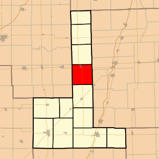
Brenton Township is one of twelve townships in Ford County, Illinois, USA. As of the 2020 census, its population was 861 and it contained 413 housing units. The township was originally called Stockton Township and was formed from a portion of Patton Township on March 15, 1859; the name was changed to Brenton Township on May 9, 1864.

Button Township is one of twelve townships in Ford County, Illinois, USA. As of the 2020 census, its population was 232 and it contained 108 housing units. The township was formed from a portion of Patton Township in December 1864.

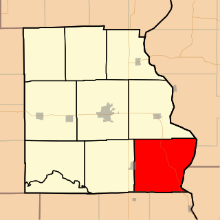
Dix Township is one of twelve townships in Ford County, Illinois, USA. As of the 2020 census, its population was 598 and it contained 268 housing units.
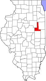
Drummer Township is one of twelve townships in Ford County, Illinois, USA. As of the 2020 census, its population was 4,046 and it contained 1,912 housing units.

Lyman Township is one of twelve townships in Ford County, Illinois, USA. As of the 2020 census, its population was 516 and it contained 260 housing units. The township was formed from a portion of Brenton Township on September 9, 1867.

Mona Township is one of twelve townships in Ford County, Illinois, USA. As of the 2020 census, its population was 267 and it contained 130 housing units. The township was formed as Delhi Township from a portion of Rogers Township on March 2, 1870; its name was changed to Mona Township on June 16, 1870.

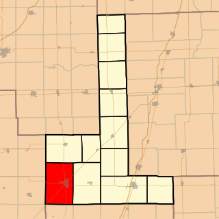
Peach Orchard Township is one of twelve townships in Ford County, Illinois, USA. As of the 2020 census, its population was 551 and it contained 255 housing units. It was formed from a portion of Sullivant Township on September 14, 1868.

Pella Township is one of twelve townships in Ford County, Illinois, USA. As of the 2020 census, its population was 160 and it contained 81 housing units. It was formed as Clyde Township from a portion of Brenton Township on March 2, 1870; its name was changed to Pella Township on June 16, 1870.

Rogers Township is one of twelve townships in Ford County, Illinois, USA. As of the 2020 census, its population was 381 and it contained 197 housing units. It was formed as Grant Township from a portion of Stockton (Brenton) Township in September, 1863; its name was changed to Rogers Township on May 9, 1864.

Wall Township is one of twelve townships in Ford County, Illinois, USA. As of the 2020 census, its population was 190 and it contained 78 housing units. The township was formed from Patton Township on June 12, 1867.
Anderson Township is one of fifteen townships in Clark County, Illinois, USA. As of the 2020 census, its population was 460 and it contained 183 housing units.

Parker Township is one of fifteen townships in Clark County, Illinois, US. As of the 2020 census, its population was 167 and it contained 107 housing units.
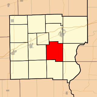
Montgomery Township is one of ten townships in Crawford County, Illinois, USA. As of the 2020 census, its population was 671 and it contained 289 housing units.

Saint Francis Township is one of fifteen townships in Effingham County, Illinois, USA. As of the 2020 census, its population was 1,194 and it contained 479 housing units.