Patton Township, Ford County, Illinois

Last updated

Patton Township
Map highlighting Patton Township, Ford County, Illinois.svg
Location in Ford County
Map of Illinois highlighting Ford County.svg
Ford County's location in Illinois
Coordinates: 40°26′47″N88°08′23″W / 40.44639°N 88.13972°W / 40.44639; -88.13972
Country United States
State Illinois
County Ford
EstablishedNovember 6, 1860
Area
  Total61.36 sq mi (158.9 km2)
  Land61.28 sq mi (158.7 km2)
  Water0.08 sq mi (0.2 km2)  0.14%
Elevation
761 ft (232 m)
Population
 (2020)
  Total5,253
  Density86/sq mi (33/km2)
Time zone UTC-6 (CST)
  Summer (DST) UTC-5 (CDT)
ZIP codes
60949, 60957
FIPS code 17-053-58122

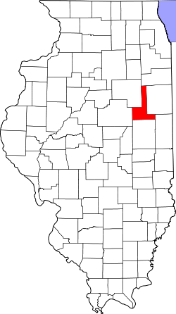
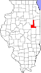
Patton Township is located in Ford County, Illinois. As of the 2020 census, its population was 5,253 and it contained 2,332 housing units. [1] It was named Prairie City Township when established as a township in Vermilion County; its name was changed to Patton Township on September 14, 1857.

Contents

Geography

According to the 2021 census gazetteer files, Patton Township has a total area of 61.36 square miles (158.92 km2), of which 61.28 square miles (158.71 km2) (or 99.86%) is land and 0.08 square miles (0.21 km2) (or 0.14%) is water. [2]

Paxton

Paxton, the county seat, is the largest town in Patton Township.

Perdueville

Perdueville is an unincorporated area in section 9 of Patton township. Extant structures include a grain elevator which is still in service next to the rail grade, now removed. The Perdueville Pheasant Habitat Area is located in section 32 of the township. [3] The habitat area was purchased in 1995 and consists of 122 acres (0.49 km2). [4]

Perdueville grain elevator in section 9 of the township. Perdueville Illinois grain elevator.jpg
Perdueville grain elevator in section 9 of the township.

Ten Mile Grove

Ten Mile Grove is said to be the earliest settlement in Patton Township with about a dozen families residing there in 1853. It was located on the Danville-Ottawa road and named such because it was ten miles (16 km) from the nearest settlement. [5] The grove is partly contained in the Howard Thomas Memorial Nature Preserve [6] . The preserve, containing many Bur oak, sustained damage in a 2004 wind storm which felled numerous trees. Thirty to fifty percent of trees were felled in some portions, especially the western part. Volunteers cleared trees from the trails, one of which had 17 trees blocking it. [7]

Sign marking Ten Mile Grove Ten Mile Grove sign.jpg
Sign marking Ten Mile Grove

Cemeteries

The township contains these seven cemeteries: Farmersville, Glen, Hall, Meharry, Pells Park, Prospect and Ten Mile Grove.

Major highways

Airports and landing strips

Demographics

As of the 2020 census [1] there were 5,253 people, 2,004 households, and 1,317 families residing in the township. The population density was 85.60 inhabitants per square mile (33.05/km2). There were 2,332 housing units at an average density of 38.00 per square mile (14.67/km2). The racial makeup of the township was 90.88% White, 0.76% African American, 0.29% Native American, 0.27% Asian, 0.00% Pacific Islander, 1.71% from other races, and 6.09% from two or more races. Hispanic or Latino of any race were 4.70% of the population.

There were 2,004 households, out of which 32.10% had children under the age of 18 living with them, 51.15% were married couples living together, 11.43% had a female householder with no spouse present, and 34.28% were non-families. 32.80% of all households were made up of individuals, and 14.10% had someone living alone who was 65 years of age or older. The average household size was 2.36 and the average family size was 2.99.

The township's age distribution consisted of 25.8% under the age of 18, 6.7% from 18 to 24, 23.8% from 25 to 44, 23.6% from 45 to 64, and 20.0% who were 65 years of age or older. The median age was 39.8 years. For every 100 females, there were 100.1 males. For every 100 females age 18 and over, there were 96.4 males.

The median income for a household in the township was $55,357, and the median income for a family was $72,098. Males had a median income of $48,711 versus $28,438 for females. The per capita income for the township was $27,217. About 8.1% of families and 12.4% of the population were below the poverty line, including 21.5% of those under age 18 and 4.7% of those age 65 or over.

Historical population
CensusPop.Note
2000 5,379
2010 5,358−0.4%
2020 5,253−2.0%
U.S. Decennial Census [8]

School districts

Political districts

Related Research Articles

<span class="mw-page-title-main">Ford County, Illinois</span> County in Illinois, United States

Ford County is a county located in the U.S. state of Illinois. According to the 2020 United States Census, it had a population of 13,534. Its county seat is Paxton. Ford County was part of the Champaign–Urbana, IL Metropolitan Statistical Area until 2018, when the Office of Management and Budget removed the county from the area.

<span class="mw-page-title-main">Gibson City, Illinois</span> City in Illinois, United States

Gibson City is a city in Ford County, Illinois, United States. The population was 3,475 at the 2020 census.

<span class="mw-page-title-main">Saybrook, Illinois</span> Village in Illinois, United States

Saybrook is a village in McLean County, Illinois, United States. The population was 654 at the 2020 census. It is part of the Bloomington–Normal Metropolitan Statistical Area.

Silver Creek Township is a township in Wright County, Minnesota, United States. The population was 2,332 at the 2000 census.

<span class="mw-page-title-main">Upper Paxton Township, Pennsylvania</span> Township in Pennsylvania, United States

Upper Paxton Township is a township in Dauphin County, Pennsylvania, United States. The population was 4,014 at the 2020 census.

<span class="mw-page-title-main">Elkhorn Grove Township, Carroll County, Illinois</span> Township in Illinois, United States

Elkhorn Grove Township is one of twelve townships in Carroll County, Illinois, USA. As of the 2020 census, its population was 197 and it contained 89 housing units.

<span class="mw-page-title-main">Freedom Township, Carroll County, Illinois</span> Township in Illinois, United States

Freedom Township is one of twelve townships in Carroll County, Illinois, USA. As of the 2020 census, its population was 799 and it contained 920 housing units.

<span class="mw-page-title-main">Schaumburg Township, Cook County, Illinois</span> Township in Illinois, United States

Schaumburg Township is one of 29 townships in Cook County, Illinois, USA. As of the 2020 census, its population was 134,809. It is in the north west corner of Cook County.

<span class="mw-page-title-main">Wheeling Township, Cook County, Illinois</span> Township in Illinois, United States

Wheeling Township is one of 29 townships in Cook County, Illinois, USA. As of the 2020 census, its population was 157,487. It is the northeasternmost and most populated of the six northwest Cook County townships that form the panhandle.

<span class="mw-page-title-main">Caledonia Township, Boone County, Illinois</span> Township in Illinois, United States

Caledonia Township is one of nine townships in Boone County, Illinois, United States. As of the 2020 census, its population was 7,294 and it contained 2,590 housing units. Sometime after 1921, Poplar Grove Township was formed from a portion of Caledonia Township.

<span class="mw-page-title-main">Poplar Grove Township, Boone County, Illinois</span> Township in Illinois, United States

Poplar Grove Township is one of nine townships in Boone County, Illinois, USA. As of the 2020 census, its population was 5,131 and it contained 1,834 housing units. Poplar Grove Township was formed from parts of Caledonia Township and Boone Township after 1921.

<span class="mw-page-title-main">South Grove Township, DeKalb County, Illinois</span> Township in Illinois, United States

South Grove Township is one of nineteen townships in DeKalb County, Illinois, USA. As of the 2020 census, its population was 447 and it contained 201 housing units. South Grove Township was renamed from Vernon Township on November 20, 1850.

<span class="mw-page-title-main">Squaw Grove Township, DeKalb County, Illinois</span> Township in Illinois, United States

Squaw Grove Township is one of 19 townships in DeKalb County, Illinois, USA. As of the 2020 census, its population was 2,717 and it contained 1,118 housing units.

<span class="mw-page-title-main">Kerr Township, Champaign County, Illinois</span> Township in Illinois, United States

Kerr Township is a township in Champaign County, Illinois, USA. As of the 2020 census, its population was 183 and it contained 64 housing units.

<span class="mw-page-title-main">Mulberry Grove Township, Bond County, Illinois</span> Township in Illinois, United States

Mulberry Grove Township is one of nine townships in Bond County, Illinois, USA. As of the 2020 census, its population was 1,133 and it contained 569 housing units.

<span class="mw-page-title-main">Pleasant Mound Township, Bond County, Illinois</span> Township in Illinois, United States

Pleasant Mound Township is one of nine townships in Bond County, Illinois, USA. As of the 2020 census, its population was 907 and it contained 446 housing units.

<span class="mw-page-title-main">Button Township, Ford County, Illinois</span> Township in Illinois, United States

Button Township is one of twelve townships in Ford County, Illinois, USA. As of the 2020 census, its population was 232 and it contained 108 housing units. The township was formed from a portion of Patton Township in December 1864.

<span class="mw-page-title-main">Wall Township, Ford County, Illinois</span> Township in Illinois, United States

Wall Township is one of twelve townships in Ford County, Illinois, USA. As of the 2020 census, its population was 190 and it contained 78 housing units. The township was formed from Patton Township on June 12, 1867.

<span class="mw-page-title-main">Bear Grove Township, Fayette County, Illinois</span> Township in Illinois, United States

Bear Grove Township is one of twenty townships in Fayette County, Illinois, USA. As of the 2020 census, its population was 553 and it contained 232 housing units. The township was originally known as Johnson Township.

<span class="mw-page-title-main">Sargent Township, Douglas County, Illinois</span> Township in Illinois, United States

Sargent Township is one of nine townships in Douglas County, Illinois, USA. As of the 2020 census, its population was 240 and it contained 125 housing units. The township contains Walnut Point State Park.

References

  1. 1 2 "Explore Census Data". data.census.gov. Retrieved January 22, 2023.
  2. Bureau, US Census. "Gazetteer Files". Census.gov. Retrieved January 22, 2023.
  3. Perdueville Habitat Area Hunter Fact Sheet Archived 2008-03-27 at the Wayback Machine
  4. Chicago Sun-Times. Rainy and gray -- perfect day: Hunting in Pheasant Habitat Area.
  5. The Pantagraph. Landmark barn to be restored; Foundation helps project in area of Ten Mile Grove. April 18, 2005.
  6. http://www.aiswcd.org/wp-content/uploads/2013/06/Ford1.pdf
  7. The Pantagraph. (Bloomington, Illinois) Grove's return came naturally. January 30, 2006.
  8. "Census of Population and Housing". Census.gov. Retrieved June 4, 2016.