Acton is a town in Middlesex County, Massachusetts, United States, approximately 21 miles (34 km) west-northwest of Boston along Massachusetts Route 2 west of Concord and about ten miles (16 km) southwest of Lowell. The population was 24,021 in April 2020, according to the United States Census Bureau. It is bordered by Westford and Littleton to the north, Concord and Carlisle to the east, Stow, Maynard, and Sudbury to the south and Boxborough to the west. Acton became an incorporated town in 1735. The town employs the Open Town Meeting form of government with a town manager and an elected, five-member select board. Acton was named the 11th Best Place To Live among small towns in the country by Money Magazine in 2015, and the 16th best in 2009 and in 2011. The local high school, Acton-Boxborough Regional High School, was named a Blue Ribbon School by the U.S. Department of Education in 2009.

Packer Park is a neighborhood in the South Philadelphia section of Philadelphia, Pennsylvania, United States that originally included 1,000 homes built in two unique builder developments, of Packer Park in the 1950s and Brinton Estates during the 1990s. It is now one of four residential communities to be designated as Packer Park. The original footprint community is also one of four adjacent communities that form Philadelphia's Sports Complex Special Services District. The approximate boundaries are Packer Avenue to the north, Hartranft Street to the south including FDR Park farther south, Broad Street to the east known as the Southern Parkway, and I-76 to the far west. Packer Park has been considered home to one of the most organized community groups in the South Philadelphia region.
The Highlands Historic District is a historic district roughly bounded by June, Cherry, and Weetamoe Streets, Lincoln, Highland, President, North Main, and Hood Avenues in Fall River, Massachusetts. The district lies just north of the Lower Highlands Historic District.
The Elm Street Historic District is a rural historic district in southern Hatfield, Massachusetts. It encompasses a landscape that has seen agricultural use since 17th century colonial days, including fields now used for tobacco farming, and historic properties located along five roads: Elm Street, Scotland Road, Sunset Road, Brook Hollow Road, and Little Neponset Road. The district is bounded on its south by the Connecticut River, on its east and north by the Mill River, with a small portion of land border in the northeast which cuts off a large meander in the river. This section, near the junction of Elm and Prospect Streets, is also where this district abuts the Mill-Prospect Street Historic District, which runs north along Prospect Street, and its eastern boundary abuts the Hatfield Center Historic District. Its western boundary is roughly a north-south line in the area of the junction of Elm and Dwight Streets.
The McKnight District is a predominantly residential neighborhood northeast of downtown Springfield, Massachusetts. The area represents a planned residential development covering several hundred acres, which was built in the mid to late 19th century. The architects of the development were John and William McKnight, who, in addition to developing and enforcing construction guidelines in the area, built and landscaped many of the properties. The area was largely built by 1910, and there has been little new construction in the area since. Most of the houses built in the area were constructed in most of the architectural styles that were popular between 1880 and 1990, although there is a predominance of the Queen Anne style. The McKnights began to develop the area, which had previously been mainly farmland, in 1870 with the purchase of a 22 acres (8.9 ha) parcel on which they and a partner built their own homes. They proceeded over the following years to acquire additional parcels of land in the area, plat out roads, and either build houses themselves, or sell plots to other builders. They enforced some uniformity in the area through the use of deed restrictions, which required uniform setback requirements, banned fencing, and required a minimum cost of construction.

Pulaski Park is a city park along the Connecticut River in Holyoke, Massachusetts. Originally called Prospect Park when it was laid out in 1884, it was given its present name in 1939 in honor of American Revolutionary War hero Casimir Pulaski, for whom there is a memorial in the park's center. The original 5.1-acre (2.1 ha) park was designed by the Olmsted Brothers landscape design firm.

The Central Street District is a historic district encompassing the traditional heart of Andover, Massachusetts prior to the development in the later 19th century of the current town center. It consists mainly of residential and religious properties along Central Street, from Phillips Street in the south to Essex Street in the north. All of the listed properties have frontage on Central Street, even if their addresses are on one of the adjacent streets.

The River Road–Cross Street Historic District is a rural agricultural historic district in Topsfield, Massachusetts. It is representative of Topsfield's development first as an agricultural community, and later as place for rural retreats. The district, which was listed on the National Register of Historic Places in 2005, is roughly bounded by River Road, Rowley Bridge Road, Cross Street, Hill Street, and Salem Road, and also includes properties facing Prospect Street and Bradstreet Lane. Much of the district was consolidated under the ownership of William Appleton Coolidge in the 20th century, and bequeathed to the Massachusetts Institute of Technology with restrictions to preserve its rural character. MIT sold the donated properties in 2000.
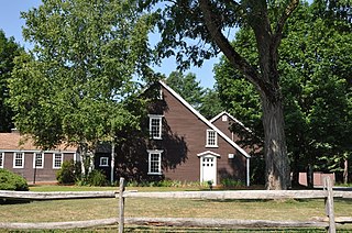
The Manning Manse is a historic house at 56 Chelmsford Road in North Billerica, Massachusetts. Built about 1696, it is one of the oldest surviving buildings in Billerica. It has further associations with local and nationally prominent members of the Manning family, and is a significant early example of historic preservation in the United States. Since the mid-20th century it has typically housed a restaurant, under lease from a family association. It was listed on the National Register of Historic Places in 1982.

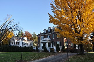
The Wedgemere Historic District encompasses the largest single 19th-century residential development of Winchester, Massachusetts. It is one of the town's largest surviving 19th-century residential subdivisions, with a concentration of high-quality residences built between about 1890 and 1920. The district was listed on the National Register of Historic Places in 1989.
The Andover Street Historic District is a linear residential historic district in the Belvidere neighborhood of eastern Lowell, Massachusetts. The district encompasses large, fashionable houses and estates that were built between the 1860s and the 1930s. It includes properties at 245—834 Andover Street, and at 569 and 579 East Merrimack Street. The district was listed on the National Register of Historic Places in 2000.
The Washington Square Historic District of Lowell, Massachusetts encompasses a historic subdivision laid out in 1832. The focal point of the subdivision is Kittridge Park, which lies on the eastern side of the district and was an original part of the subdivision plan developed by the Nesmith Brothers. It was the first significant residential subdivision in the city aimed at a wealthier clientele, and was designed by landscape architect Alexander Wadsworth. The district was added to the National Register of Historic Places in 1982, and expanded slightly in 1999.

The Old Chestnut Hill Historic District encompasses the historic residential heart of the Newton portion of Chestnut Hill, Massachusetts. When first listed on the National Register of Historic Places in 1986, the district extended along Hammond Street, between Beacon Street and the MBTA Green Line right-of-way, and along Chestnut Hill Road between Hammond and Essex, including properties along a few adjacent streets. The district was expanded in 1990 to include more of Chestnut Hill Road and Essex Road, Suffolk Road and the roads between it and Hammond, and a small section south of the Green Line including properties on Hammond Street, Longwood Road, and Middlesex Road. A further expansion in 1999 added a single property on Suffolk Road.
The Beacon Street Historic District is a historic district running most of the length of Beacon Street in Brookline, Massachusetts, roughly from Saint Mary's Road, near Kenmore Square, to Ayr Road near Cleveland Circle. It includes a small number of properties on adjacent streets, and was listed on the National Register of Historic Places in 1985.

The Fisher Hill Historic District encompasses a residential area in central Brookline, Massachusetts. The area was subdivided and built out beginning in the 1880s, with landscaping design by Frederick Law Olmsted and John Charles Olmsted. The district is bounded on the west by Chestnut Hill Avenue, Baxter Road, and Channing Road, and on the south by Massachusetts Route 9. Its eastern boundary runs along Buckminster Street to Dean Road, joining the northern boundary of Clinton Road, running between Dean Road and Chestnut Hill Avenue. Prior to its development in the 1880s, Fisher Hill had a relatively small number of landowners. Some of them banded together, hiring the Olmsteds to design a subdivision plan for the entire district. Lots were sold to wealthy individuals, who built fashionable houses, often designed by architects. In 1914 a restrictive covenant was entered into by a significant number of property owners, restricting their properties to strictly single-family residential uses.

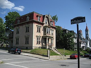
The Migeon Avenue Historic District encompasses a group of elegant residential properties on a one-block stretch of Migeon Avenue in Torrington, Connecticut. Consisting of five properties and four contributing primary buildings, this area was home to some of Torrington's leading businessmen at the turn of the 20th century. The houses are of high architectural quality, and original landscaping was done by the Olmsted Brothers landscape design firm. The district was listed on the National Register of Historic Places in 2002.

The City of Springfield, Massachusetts, has 19 distinct neighborhoods. Many feature subdivisions known by other names, such as The X, Hungry Hill, and Mason Square. Springfield's neighborhoods fan out north, south, and east, from its original, colonial settlement in what is now Metro Center.

The Capitol Complex Historic District encompasses the principal historic elements of Maine's state administration complex at Capitol and State Streets in Augusta, Maine. Included in the district are the Maine State House, Capitol Park, The Blaine House, the Burton Cross Office Building, and a number of state-owned 19th century residences in the vicinity of the Blaine House. The district was listed on the National Register of Historic Places in 2001.

The Weston Village Historic District encompasses the town center and principal village of Weston, Vermont. Centered on Farrar Park, which serves as the town green, it includes a diversity of architectural styles from the late 18th century to about 1935, and includes residential, civic, commercial, industrial and religious buildings. It was listed on the National Register of Historic Places in 1985.

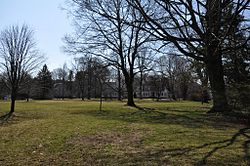
Lewis Fulton Memorial Park is a public park in the city of Waterbury, Connecticut. Located north of the city center, it was developed in the 1920s through the philanthropy of William Fulton, a brass company owner, as a memorial to his son Lewis. Its grounds were designed by the Olmsted Brothers landscape architects, and were largely completed by 1925. The park includes facilities for both active and passive recreation, and retains many Olmsted-designed features. It was listed on the National Register of Historic Places in 1990.