
Gawler is the oldest country town on the Australian mainland in the state of South Australia. It was named after the second Governor of the colony of South Australia, George Gawler. It is about 40–44 km (25–27 mi) north of the state capital, Adelaide, and is close to the major wine producing district of the Barossa Valley. Topographically, Gawler lies at the confluence of two tributaries of the Gawler River, the North and South Para rivers, where they emerge from a range of low hills.

Deakin is a suburb of Canberra, Australian Capital Territory, Australia. Development began in the 1920s, although the vast majority of the suburb was built after 1945. It is a largely residential suburb. It includes The Lodge, and the Royal Australian Mint.
Light Regional Council is a local government area north of Adelaide in South Australia. It is based in the town of Kapunda, and includes the towns of Freeling, Greenock, Hansborough, Hewett, Roseworthy and Wasleys.

The Town of Gawler is a local government area located north of Adelaide city centre in South Australia containing Gawler and its suburbs. The corporate town was established in 1857 due to the township's residents' dissatisfaction at being governed by three different district councils.

The Division of Wakefield was an Australian electoral division in the state of South Australia. The seat was a hybrid rural-urban electorate that stretched from Salisbury in the outer northern suburbs of Adelaide at the south of the seat right through to the Clare Valley at the north of the seat, 135 km from Adelaide. It included the suburbs of Elizabeth, Craigmore, Munno Para, and part of Salisbury, and the towns of Balaklava, Clare, Freeling, Gawler, Kapunda, Mallala, Riverton, Tarlee, Virginia, Williamstown, and part of Port Wakefield.

Semaphore is a northwestern suburb of Adelaide in the Australian state of South Australia. It is located on the Gulf St Vincent coastline of the Lefevre Peninsula about 14 kilometres (8.7 mi) from the Adelaide city centre.

Blanchetown is a small township in South Australia, on the (west) bank of the Murray River, 130 kilometres (81 mi) northeast of Adelaide. The Blanchetown Bridge is the westernmost of the four crossings of the Sturt Highway over the Murray River. During the nineteenth century it was an important transportation centre on the lower Murray. In the early 21st century, Blanchetown has been described as "a strange mixture of historic buildings and temporary shacks built by holidaymakers on the banks of the river". Blanchetown is widely regarded as the entrance to the Riverland district.

The town of Balaklava is located in South Australia, 92 kilometres north of Adelaide in the Mid North region. It is on the south bank of the Wakefield River, 25 kilometres east of Port Wakefield.

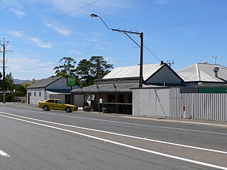
Wasleys is a small town north-west of Gawler, South Australia. Roseworthy College is located around 6 km (3.7 mi) south of the town. At the 2016 census, Wasleys had a population of 348.

Ovingham is an inner northern suburb of Adelaide, South Australia. It is located in the cities of Charles Sturt and Prospect.

The Adelaide Plains Council is a local government area in South Australia. It consists of a largely rural region along the Gulf St Vincent, covering a total area of approximately 926 km2. The council seat lies at Mallala, but it also maintains a service centre at Two Wells.
Sandy Creek is a town in South Australia. The town is situated approximately 6 kilometres east of Gawler and is the last town passed through before reaching Barossa Valley at Lyndoch.
Port Gawler is a locality and former port on Gulf St Vincent on the central Adelaide Plains in South Australia. Port Gawler is located 43 kilometres (27 mi) north west of Adelaide in the Adelaide Plains Council local government area at the mouth of the Gawler River.
Gawler West, is a suburb of the South Australian town of Gawler, located in the northern Adelaide metropolitan area region, 43 km north of Adelaide. It is bordered by the Gawler River and the Gawler railway line and the suburbs of Gawler South, and Evanston. During the 2000s period, part of the suburb was renamed Reid by the South Australian Geographical Names Advisory Committee, replacing the Gawler Bypass Road as the western boundary by the Gawler River on the west and north.

Wakefield Street is a main thoroughfare intersecting the centre of the South Australian capital, Adelaide, from east to west at its midpoint. It crosses Victoria Square in the centre of the city, which has a grid street plan. It continues as Wakefield Road on its eastern side, through the eastern Adelaide Park Lands.

North Adelaide is a predominantly residential precinct and suburb of the City of Adelaide in South Australia, situated north of the River Torrens and within the Adelaide Park Lands.
Evanston Park is a northern suburb of Adelaide, South Australia. It is on the southeastern side of Gawler. It is on the eastern side of Main North Road and Adelaide Road extending north from near the intersection with Gawler Bypass Road.
Ward Belt is a locality to the west of Gawler in South Australia. The area was named after James Ward and his wife, who arrived in South Australia in the Olivia in 1853. The area is predominantly used for grain, beef and sheep farming.
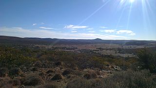
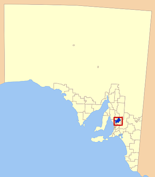
Gawler Ranges is a locality in the Australian state of South Australia located on Eyre Peninsula about 380 kilometres north-west of the Adelaide city centre and about 48 kilometres north of the town centre of Wudinna and which is associated with the protected area known as the Gawler Ranges National Park.

The Division of Spence is an electoral district for the Australian House of Representatives. It is located in the outer northern suburbs of Adelaide in South Australia.

