
Route 68 is a 36.14-mile-long (58.16 km) south–north state highway in Massachusetts. Its southern terminus is at Route 122A in Holden and its northern terminus is at Route 32 in Royalston. Along the way it intersects Route 2 in Gardner and U.S. Route 202 (US 202) in Templeton.

The Barre Common District is a historic district encompassing the town common of Barre, Massachusetts, and immediately adjacent historic buildings. It is bounded roughly by South, Exchange, Main, Pleasant, Broad, School and Grove Streets. The Barre common was laid out in 1792, and has been a focus of the town's civic life ever since, and is flanked by a number of high-quality Greek Revival buildings, as well as those in other styles. The district was listed on the National Register of Historic Places in 1976.

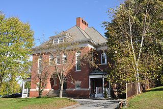
The Brookfield Common Historic District encompasses a historically significant portion of the town center of Brookfield, Massachusetts. It is focused on the town common, which extends south from Main Street to Lincoln Street, and includes a dense cluster of houses on roads to its east, as well as properties on Main Street and the Post Road. The district includes more than 100 properties, including the Colonial Revival Town Hall, Banister Memorial Hall, and Romanesque Revival Congregation Church. The district was added to the National Register of Historic Places in 1990.

The Lunenburg Historic District is a historic district encompassing the historic center of Lunenburg, Massachusetts. The district is centered on a stretch of Main Street which connects two triangular intersections. It includes many of the town's oldest buildings, including the c. 1724 Cushing House, and the c. 1730 Stillman Stone House. Three of the town's most significant institutional buildings were built before 1850: the town hall, the Congregational church, and the Methodist church. The district was added to the National Register of Historic Places in 1988.

The Old Centre Historic District is a historic district encompassing the historic town center of Winchendon, Massachusetts. It includes the town's first cemetery, the First Congregational Church, and the oldest surviving house in town, and only one building constructed after 1850. The district was added to the National Register of Historic Places in 1987.

The Center Village District encompasses the historic village center of Lancaster, Massachusetts. Settled in 1643, it has few traces of its early history, but is now a well-kept rural town center with a predominantly residential and civic character. It includes the First Church of Christ, Lancaster, which is a U.S. National Historic Landmark, and was listed on the National Register of Historic Places in 1977.

Hubbardston Town Common Historic District encompasses the town common of Hubbardston, Massachusetts, the adjacent 1773 First Parish Church, and the town's first burying ground. It has been the center of the town's civic and religious life since its incorporation in the 1760s, and was listed on the National Register of Historic Places in 2000. The district was named as one of the 1,000 Places to Visit in Massachusetts by the Great Places in Massachusetts Commission.

Phillipston Center Historic District encompasses the historic village center of Phillipston, Massachusetts. The town was first settled in 1751 on land grants made in the 1730s, and was incorporated as a separate town in the 1770s. The surviving village center not far from the location of the first settlement, eventually came to include a tavern. After incorporation, the center developed around what is now the junction of the Baldwinville, Petersham, and Templeton Roads, although this took time, possibly because of difficulties associated with the American Revolutionary War. As a result, the district has relatively few properties that date to the 18th century. All of these are modest vernacular residential structures. The town grew only modestly until 1830, after which time its population declined, not reaching the same level until 1980, 150 years later. As a result of the lack of growth, most of the properties in the district are Federal and Greek Revival in character. Many of the institutional buildings in the center date to the late 19th and early 20th centuries. The district was added to the National Register of Historic Places in 1999.

The Harvard Center Historic District is a historic district encompassing the traditional village center of Harvard, Massachusetts, USA. The district is centered on the town common, a triangular grassy space bounded by Elm Street, Still River Road, and Ayer Road. The common is ringed by residences, civic and religious buildings, and a small commercial area. The common was laid out when the town was founded in 1732, and has grown, mainly in periods of growth at the late 18th and late 19th/early 20th centuries. Most of the village's buildings post-date 1831. The district was added to the National Register of Historic Places in 1997.
The Baldwinville Village Historic District encompasses the historic elements of the village of Baldwinville, a 19th-century mill village in northern Templeton, Massachusetts. Although its industrial elements have largely been lost, the district retains period housing and civic buildings. It was listed on the National Register of Historic Places in 1986.

The Shrewsbury Historic District encompasses the historic early center of the town of Shrewsbury, Massachusetts. It consists of the town common, laid out in 1721 at what are now Main and Prospect Streets, and buildings adjacent or nearby. The district was declared locally in 1972, and was added to the National Register of Historic Places in 1976.

The Sutton Center Historic District is a historic district encompassing the center of the village of Sutton, Massachusetts. The district, which covers 435 acres (176 ha), is centered on the junction of Boston Road, Singletary Avenue, and Uxbridge Road. Boston Road is a major east–west route through the town, and the other two roads run north–south through the village center. The Colombian building was built in 1957. A typically rural village center, its civic and institutional buildings are clustered near the intersection on its south side, in the general area of the town common. The town common and cemetery were laid out in 1719, after settlement of the township began in 1716. There are a few surviving houses that date to the middle of the 18th century or earlier; exact dates for most are uncertain. There are only a few institutional buildings: the 1829 Congregational Church, the 1983 Town Hall, built on the site of the town's first purpose-built town hall (1885), and Rufus Putnam Hall, an 1824 school building and Masonic lodge that now houses the local history museum. Only one commercial structure the 1839 Brick Block, stands in the village. There is also a historic animal pound, a rectangular stone structure used to pen stray livestock, which dates to the early days of the town.

Becket Center Historic District is a historic district encompassing the historic early center of Becket, Massachusetts. Centered at the junction of Massachusetts Route 8 and YMCA Road, this area was the town's civic heart and a center of industry until it was eclipsed in importance by North Becket, which was served by the railroad. Most of the architecture in the district is in the Federal and Greek Revival styles popular in the late 18th to mid 19th centuries. The district was added to the National Register of Historic Places in 1982.

North Becket Village Historic District is a historic district encompassing the historic village of North Becket in the Berkshire hill town of Becket, Massachusetts. The village developed rapidly as the main economic and civic center of the town in a 20-year period beginning in 1841 with the arrival of the Western Railroad, and retains many fine examples of Greek Revival architecture. It was listed on the National Register of Historic Places in 1988.

The Upper Historic District is a historic district encompassing the historic center of Washington, Massachusetts. Centered on the junction of Washington Mountain Road and Branch Road, the town center flourished from the town's establishment in the 1750s until the center of the town's business moved closer to the newly lain railroad in the 1830s. The district includes the old town hall, cemetery, common, and pound, as well as a number of residences. A meeting house (church) and schoolhouse once stood in the area, but the 1792 church was destroyed by lightning in 1859, and the schoolhouse is no longer extant. The district was added to the National Register of Historic Places in 1987. It was listed as part of the Washington Multiple Property Submission (MPS).

The Brimfield Center Historic District is a historic district encompassing the historic center of Brimfield, Massachusetts. The district is centered on the town common, and includes properties radiating out from that center on Main Street, Brookfled, Wales, Sturbridge and Warren Roads. Brimfield Center was first laid out in 1721 along a Native American trail that ran through the area, and developed over the years into what is now US Route 20, or Main Street. The district includes properties ranging from early colonial houses to the town hall, built in 1878. The center has retained some coherence because the Brimfield Fair, a major antiques market that takes place three times a year, takes up significant open space in the areas near the center. The district was listed on the National Register of Historic Places in 2006.

The Brookline Town Green Historic District encompasses the historic colonial heart of the town of Brookline, Massachusetts. Centered on a stretch of Walnut Street between Warren and Chestnut Streets, this area is where the town's first colonial meeting house and cemetery were laid out, and was its center of civic life until the early 19th century. The district was listed on the National Register of Historic Places in 1980.

Elias Carter (1781-1864) was an American architect whose first church design, at Brimfield, Massachusetts, was completed in 1805. He was born in 1781 to Timothy and Sarah (Walker) Carter in Ward, a village of Auburn, Massachusetts. His father, a builder, died when he was three, and the family moved to Hardwick when his mother remarried, to a farmer there. He followed in his father's profession, working in the American South for a time before returning to central Massachusetts. He was responsible for the construction of a number of churches in central Massachusetts, which an early biographer described as "typical white steepled churches of New England". His most influential design appears to have been the church in Templeton, Massachusetts, which inspired the design of at least two others. He also built houses throughout central Massachusetts, as well as a wing of the Westborough State Hospital, and played a role in the construction of the New Hampshire state insane asylum.

The Town Center Historic District encompasses the historic village center of South Hampton, New Hampshire. Centered around the Barnard Green, the town common, on New Hampshire Route 107A, it includes architectural reminders of the town's growth and change over time. The district was listed on the National Register of Historic Places in 1983.

The Southborough Center Historic District encompasses a historically significant portion of the town center of Southborough, Massachusetts. It extends from the Fay School grounds in the west, along Main Street to the railroad crossing east of Lanisquama Road. The area has been the town center since its founding in 1727, and now houses a diversity of 19th and early 20th-century architecture. The district was added to the National Register of Historic Places in 1990.


