Terrace Hills Pasture

Last updated
Terrace Hills Pasture
Site of Special Scientific Interest
Terrace Hill Pasture 7.jpg
Area of Search Leicestershire
Grid reference SK 794 309 [1]
InterestBiological
Area11.3 hectares [1]
Notification 1983 [1]
Location map Magic Map

Terrace Hills Pasture is an 11.3 hectare biological Site of Special Scientific Interest north of Eastwell in Leicestershire. [1] [2]

Site of Special Scientific Interest conservation designation denoting a protected area in the United Kingdom

A Site of Special Scientific Interest (SSSI) in Great Britain or an Area of Special Scientific Interest (ASSI) in the Isle of Man and Northern Ireland is a conservation designation denoting a protected area in the United Kingdom and Isle of Man. SSSI/ASSIs are the basic building block of site-based nature conservation legislation and most other legal nature/geological conservation designations in the United Kingdom are based upon them, including national nature reserves, Ramsar sites, Special Protection Areas, and Special Areas of Conservation. The acronym "SSSI" is often pronounced "triple-S I".

Eastwell, Leicestershire village in United Kingdom

Eastwell is a village and ecclesiastical parish in Leicestershire, England.

Leicestershire County of England

Leicestershire is a landlocked county in the English Midlands. The county borders Nottinghamshire to the north, Lincolnshire to the north-east, Rutland to the east, Northamptonshire to the south-east, Warwickshire to the south-west, Staffordshire to the west, and Derbyshire to the north-west. The border with most of Warwickshire is Watling Street.

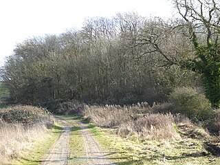
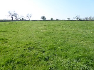
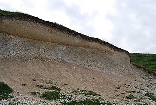
This site has been designated an SSSI as an example of old calcareous pasture, but some areas are former quarries, and as a result there is an undulating terrain. The dominant grasses are crested dog's-tail, sweet vernal grass and red fescue, and there is also a small stream with an area of marsh. [3]

Calcareous an adjective meaning mostly or partly composed of calcium carbonate

Calcareous is an adjective meaning "mostly or partly composed of calcium carbonate", in other words, containing lime or being chalky. The term is used in a wide variety of scientific disciplines.

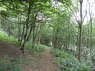
The site is composed of two adjoining fields. There is no public access to the larger western field, but a public footpath goes through the smaller eastern one.

Related Research Articles

Brampton Meadow

Brampton Meadow is a one hectare biological Site of Special Scientific Interest north-west of Brampton in Cambridgeshire.

Bloody Oaks Quarry

Bloody Oaks Quarry is a 1.3 hectare biological Site of Special Scientific Interest north-west of Great Casterton in Rutland. It is owned and managed by the Leicestershire and Rutland Wildlife Trust.

Charnwood Lodge

Charnwood Lodge is a 134.2 hectare biological and geological Site of Special Scientific Interest in Charnwood Forest, east of Coalville in Leicestershire. It is a National Nature Reserve, and contains two Geological Conservation Review sites. It is managed by the Leicestershire and Rutland Wildlife Trust.

Southorpe Roughs

Southorpe Roughs is a 9.8 hectare Site of Special Scientific Interest west of Southorpe in Cambridgeshire.

Geddington Chase SSSI

An area of 39.1 hectares in the north-west corner of Geddington Chase has been designated a biological Site of Special Scientific Interest (SSSI). It is located south-east of Corby in Northamptonshire.

Coombe Hill Hollow

Coombe Hill Hollow is a 4.3 hectare biological Site of Special Scientific Interest north of Sibbertoft in Northamptonshire.

Wollaston Meadows

Wollaston Meadows is a 14.3 hectare biological Site of Special Scientific Interest south of Wellingborough in Northamptonshire.

Racecourse Farm Fields

Racecourse Farm Fields is a 5 hectare biological Site of Special Scientific Interest in Easton on the Hill in Northamptonshire.

Plumpton Pasture

Plumpton Pasture is a 3.6 hectare biological Site of Special Scientific Interest east of Towcester in Northamptonshire.

Glapthorn Cow Pasture nature reserve in the United Kingdom

Glapthorn Cow Pasture is a 28.2 hectare biological Site of Special Scientific Interest north-west of Oundle in Northamptonshire. It is managed by the Wildlife Trust for Bedfordshire, Cambridgeshire and Northamptonshire.

Briery Wood Heronry, Belvoir

Briery Wood Heronry is a 5.7 hectare biological Site of Special Scientific Interest in the grounds of Belvoir Castle in Leicestershire.

Harby Hill Wood

Harby Hill Wood is a 16.9 hectare biological Site of Special Scientific Interest west of Eastwell in Leicestershire.

Muston Meadows

Muston Meadows is an 8.8 hectare biological Site of Special Scientific Interest south of Muston in Leicestershire. It is also a National Nature Reserve and a Nature Conservation Review site.

Ryhall Pasture and Little Warren Verges

Ryhall Pasture and Little Warren Verges is a 6.2 hectare biological Site of Special Scientific Interest north of the village of Ryhall. Little Warren Verges is in Lincolnshire and Ryhall Pasture is in Rutland.

Seaton Meadows

Seaton Meadows is an 11.4 hectare biological Site of Special Scientific Interest east of Seaton in Rutland. It is owned and managed by Plantlife.

Sheepy Fields

Sheepy Fields is a 4.9 hectare biological Site of Special Scientific Interest north of Sheepy Magna in Leicestershire.

Misterton Marshes

Misterton Marshes is a 6.8 hectare biological Site of Special Scientific Interest north of Misterton in Leicestershire.

Croft Hill

Croft Hill is a two hectare biological Site of Special Scientific Interest north of Croft in Leicestershire.

Lount Meadows

Lount Meadows is a 8.5 hectares biological Site of Special Scientific Interest south of Lount in Leicestershire.

References

  1. 1 2 3 4 "Designated Sites View: Terrace Hills Pasture". Sites of Special Scientific Interest. Natural England. Retrieved 27 August 2017.
  2. "Map of Terrace Hills Pasture". Sites of Special Scientific Interest. Natural England. Retrieved 27 August 2017.
  3. "Terrace Hills Pasture citation" (PDF). Sites of Special Scientific Interest. Natural England. Retrieved 27 August 2017.

Coordinates: 52°52′08″N0°49′16″W / 52.869°N 0.821°W / 52.869; -0.821

Geographic coordinate system Coordinate system

A geographic coordinate system is a coordinate system that enables every location on Earth to be specified by a set of numbers, letters or symbols. The coordinates are often chosen such that one of the numbers represents a vertical position and two or three of the numbers represent a horizontal position; alternatively, a geographic position may be expressed in a combined three-dimensional Cartesian vector. A common choice of coordinates is latitude, longitude and elevation. To specify a location on a plane requires a map projection.