Charnwood Forest is a hilly tract in north-western Leicestershire, England, bounded by Leicester, Loughborough and Coalville. The area is undulating, rocky and picturesque, with barren areas. It also has some extensive tracts of woodland; its elevation is generally 600 feet (180 m) and upwards, the area exceeding this height being about 6,100 acres (25 km2). The highest point, Bardon Hill, is 912 feet (278 m). On its western flank lies an abandoned coalfield, with Coalville and other former mining villages, now being regenerated and replanted as part of the National Forest. The M1 motorway, between junctions 22 and 23, cuts through Charnwood Forest.
The Leicestershire and Rutland Wildlife Trust (LRWT) is one of 46 wildlife trusts across the United Kingdom. It manages nature reserves in Leicestershire and Rutland, and was founded in 1956 as the Leicestershire and Rutland Trust for Nature Conservation. As of January 2018, it has over 16,000 members, a staff of about 25 and more than 500 volunteers. It is based in Leicester, and is managed by a Council of Trustees which is elected by the members. It is a charity which covers all aspects of nature conservation, and works to protect wild places and wildlife.

Tilton on the Hill is a village and a former civil parish, now in the parish of Tilton on the Hill and Halstead in the Harborough district of Leicestershire. The population of the civil parish of Tilton on the Hill and Halstead at the 2011 census was 601. It lies 2 miles north of the A47, on the B6047 to Melton Mowbray. Halstead civil parish was merged with Tilton on 1 April 1935, while the deserted medieval village of Whatborough was merged in on 1 April 1994. Marefield remains a separate civil parish, but is part of the Tilton Electoral Ward. In 1931 the parish of Tilton had a population of 152. St Peter's Tilton, the Parish Church is in the parish of Halstead, as is the vicarage.

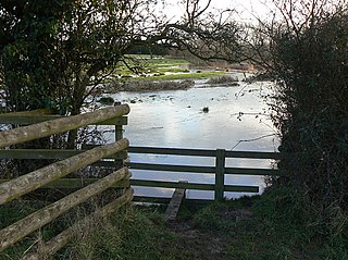
The Eye Brook is a watercourse in the East Midlands of England and a tributary of the River Welland. It is around 18 miles (29 km) long.

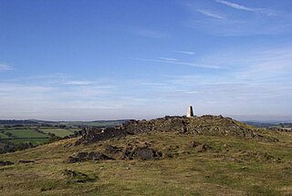
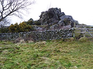
Charnwood Lodge is a 134.2-hectare (332-acre) biological and geological Site of Special Scientific Interest in Charnwood Forest, east of Coalville in Leicestershire. It is a national nature reserve, and contains two Geological Conservation Review sites. It is managed by the Leicestershire and Rutland Wildlife Trust.

Dimminsdale is a 37 hectare geological biological and Site of Special Scientific Interest partly in Derbyshire and partly in Leicestershire. It is located east of Calke in Derbyshire. It is a Geological Conservation Review site, and a area of 23.5 hectares is owned by Severn Trent Water and managed by the Leicestershire and Rutland Wildlife Trust.

Ketton Quarries is a 115.6-hectare (286-acre) biological and geological Site of Special Scientific Interest east of Ketton in Rutland. It is a Geological Conservation Review site, and an area of 27.5 hectares is managed by the Leicestershire and Rutland Wildlife Trust.
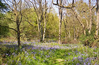
Launde Big Wood is a 41.1 hectares biological Site of Special Scientific Interest east of Leicester. It is part of Launde Woods nature reserve, which is owned by the Leicester Diocesan Board of Finance and managed by the Leicestershire and Rutland Wildlife Trust.
Cribb's Meadow is a 4.2-hectare (10-acre) nature reserve east of Wymondham in Leicestershire. It is owned and managed by the Leicestershire and Rutland Wildlife Trust, and is designated a biological Site of Special Scientific Interest under the name Cribb's Lodge Meadows. It is also a National Nature Reserve and a Nature Conservation Review site, Grade 2.
Croft Pasture is a 6.2-hectare (15-acre) biological Site of Special Scientific Interest on the outskirts of Croft in Leicestershire. Most of the site, totalling 5.8 hectares, is owned and managed by the Leicestershire and Rutland Wildlife Trust.

Leighfield Forest SSSI is an 11.3 hectares biological Site of Special Scientific Interest east of Skeffington in Leicestershire, England. It consists of several fragments, including Tugby Wood, Loddington Reddish, Brown's Wood, Skeffington Wood and Tilton Wood, of the former medieval hunting Leighfield Forest, which straddles Leicestershire and Rutland. It is a Nature Conservation Review site, Grade II.

Stonesby Quarry is a 3.2 hectares biological Site of Special Scientific Interest between Stonesby and Waltham on the Wolds in Leicestershire. It is part of a 4 hectare nature reserve managed by the Leicestershire and Rutland Wildlife Trust.

Breedon Cloud Wood and Quarry is a 63.3 hectares biological and geological Site of Special Scientific Interest north-east of Worthington in Leicestershire. It is a Geological Conservation Review site. An area of 33 hectares is managed as a nature reserve by the Leicestershire and Rutland Wildlife Trust.
Wymondham Rough is a 6.0 hectares biological Site of Special Scientific Interest (SSSI) east of Stapleford in Leicestershire. The SSSI is part of the 12.5 hectare Wymondham Rough nature reserve, which is managed by the Leicestershire and Rutland Wildlife Trust.
