
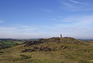
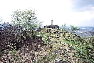
Bradgate Park is a public park in Charnwood Forest, in Leicestershire, England, northwest of Leicester. It covers 850 acres. The park lies between the villages of Newtown Linford, Anstey, Cropston, Woodhouse Eaves and Swithland. The River Lin runs through the park, flowing into Cropston Reservoir which was constructed on part of the park. To the north-east lies Swithland Wood. The park's two well known landmarks, Old John and the war memorial, both lie just above the 210 m (690 ft) contour. The park is part of the 399.3 hectare Bradgate Park and Cropston Reservoir Site of Special Scientific Interest, which has been designated under both biological and geological criteria.
Charnwood Forest is a hilly tract in north-western Leicestershire, England, bounded by Leicester, Loughborough and Coalville. The area is undulating, rocky and picturesque, with barren areas. It also has some extensive tracts of woodland; its elevation is generally 600 feet (180 m) and upwards, the area exceeding this height being about 6,100 acres (25 km2). The highest point, Bardon Hill, is 912 feet (278 m). On its western flank lies an abandoned coalfield, with Coalville and other former mining villages, now being regenerated and replanted as part of the National Forest. The M1 motorway, between junctions 22 and 23, cuts through Charnwood Forest.
The Leicestershire and Rutland Wildlife Trust (LRWT) is one of 46 wildlife trusts across the United Kingdom. It manages nature reserves in Leicestershire and Rutland, and was founded in 1956 as the Leicestershire and Rutland Trust for Nature Conservation. As of January 2018, it has over 16,000 members, a staff of about 25 and more than 500 volunteers. It is based in Leicester, and is managed by a Council of Trustees which is elected by the members. It is a charity which covers all aspects of nature conservation, and works to protect wild places and wildlife.

Beacon Hill, near Loughborough, in Leicestershire, England, is a popular country park. It is one of several beacon hills in the United Kingdom. It is part of Beacon Hill, Hangingstone and Outwoods Site of Special Scientific Interest.
Bardon Hill is the highest Hill in Leicestershire and on a clear day the Malvern and Shropshire Hills, summits in Derbyshire and Lincoln Cathedral can be seen. However, the Sugar Loaf in South Wales, sometimes cited as visible from Bardon, cannot be seen, being over 90 miles (140 km) away.
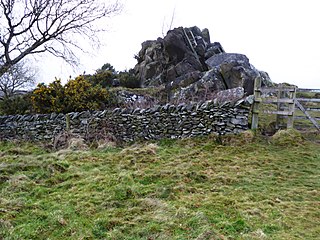
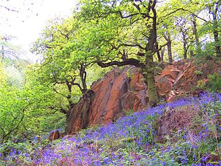
Swithland Wood and The Brand is a 87.9 hectares biological Site of Special Scientific Interest south of Woodhouse Eaves in Leicestershire. Swithland Wood is a Nature Conservation Review site, Grade II. The Brand is designated a Precambrian site in the Geological Conservation Review, but the dating has been changed due to the discovery of trace fossils from the succeeding Cambrian period.
The Outwoods is a 40 hectares ancient wood and visitor attraction overlooking Loughborough and the Soar Valley in Leicestershire, England. It has rare rock outcrops, many species of woodland plants and substantial wildlife, and it is part of Beacon Hill, Hangingstone and Outwoods Site of Special Scientific Interest. Situated within Charnwood Forest the Outwoods stands on some of the oldest exposed rocks in Britain, being formed in the Precambrian era.

Swithland Reservoir is a reservoir in the English county of Leicestershire. It is north-east of the village of Swithland from which it takes its name, north-west of Rothley and approximately 133 metres (145 yd) south-west of Mountsorrel Quarry. It is part of the 187.1-hectare (462-acre) Buddon Wood and Swithland Reservoir Site of Special Scientific Interest (SSSI).

Charnwood Lodge is a 134.2-hectare (332-acre) biological and geological Site of Special Scientific Interest in Charnwood Forest, east of Coalville in Leicestershire. It is a national nature reserve, and contains two Geological Conservation Review sites. It is managed by the Leicestershire and Rutland Wildlife Trust.

Devil's Chapel Scowles is a 44.79-hectare (110.7-acre) biological Site of Special Scientific Interest in Gloucestershire, notified England, in 1998. The site lies in the Forest of Dean and has four units of assessment by Natural England.

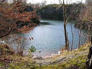
Bardon Hill Quarry is a 58.2-hectare (144-acre) geological Site of Special Scientific Interest east of Coalville in Leicestershire. It is a Geological Conservation Review site.

Grace Dieu and High Sharpley is an 86 hectare biological and geological Site of Special Scientific Interest between Coalville and Shepshed in Leicestershire. Grace Dieu Quarry is a Geological Conservation Review site.

One Barrow Plantation is a 1.8 hectares geological Site of Special Scientific Interest (SSSI) south-west of Shepshed in Leicestershire. It is a Geological Conservation Review site. Part of the site is in the Blackbrook Reservoir biological SSSI.

Ives Head is a 5 hectares geological Site of Special Scientific Interest south of Shepshed in Leicestershire. It is a Geological Conservation Review site.

Cliffe Hill Quarry is a 19.2 hectares geological Site of Special Scientific Interest on the western outskirts of Markfield in Leicestershire. It is a Geological Conservation Review site.

Ulverscroft Valley is a 110.8-hectare (274-acre) biological Site of Special Scientific Interest north-west of Markfield in Leicestershire. The site is in five separate blocks, and two areas are nature reserves managed by the Leicestershire and Rutland Wildlife Trust (LRWT). Lea Meadows is owned by the LRWT and it is also a scheduled monument. Part of Ulverscroft Nature Reserve is owned by the LRWT and part is owned by the National Trust and leased to the LRWT.