Coalville Meadows

Last updated
Coalville Meadows
Site of Special Scientific Interest
Coalville Meadows 2.jpg
Area of Search Leicestershire
Grid reference SK 446 151 [1]
Interest Biological
Area 6.0 hectares (15 acres) [1]
Notification 1983 [1]
Location map Magic Map

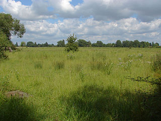
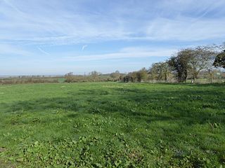
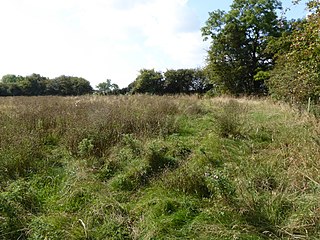
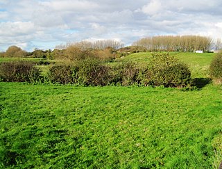
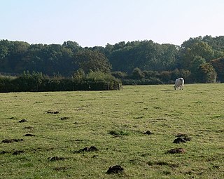
Coalville Meadows is a 6.0 hectares (15 acres) biological Site of Special Scientific Interest between Whitwick and Coalville in Leicestershire. [1] [2] It is managed by the Friends of Holly Hayes Wood. [3]

Site of Special Scientific Interest Conservation designation denoting a protected area in the United Kingdom

A Site of Special Scientific Interest (SSSI) in Great Britain or an Area of Special Scientific Interest (ASSI) in the Isle of Man and Northern Ireland is a conservation designation denoting a protected area in the United Kingdom and Isle of Man. SSSI/ASSIs are the basic building block of site-based nature conservation legislation and most other legal nature/geological conservation designations in the United Kingdom are based upon them, including national nature reserves, Ramsar sites, Special Protection Areas, and Special Areas of Conservation. The acronym "SSSI" is often pronounced "triple-S I".

Whitwick a village located in North West Leicestershire, United Kingdom

Whitwick is a large village in Leicestershire, England, close to the town of Coalville in the northwest of the county. It lies in an ancient parish which formerly included the equally historic villages of Thringstone and Swannington. It was an important manor in the Middle Ages, which once included Bardon and Markfield, parts of Hugglescote, Donington le Heath, Ratby, Bocheston, Newtown Unthank and Whittington. As early as 1293, Whitwick had a weekly market and a four-day fair. The population of Whitwick, according to the 2001 census was 10,815 persons. 8,092 of these fell into the 16-74 working age range, although only 4,689 were employed. The population of the village at the 2011 census had fallen to 8,612.

Coalville town in Leicestershire, England

Coalville is a market town in North West Leicestershire, England, with a population at the 2011 census of 34,575. It lies on the A511 trunk road between Leicester and Burton-upon-Trent, close to junction 22 of the M1 motorway where the A511 meets the A50 between Ashby-de-la-Zouch and Leicester. It borders the upland area of Charnwood Forest to the east of the town.

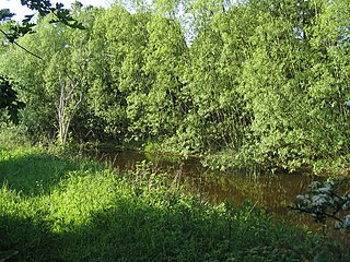
It is one of the best examples of neutral grassland that has developed on the somewhat leached clay soils of Leicestershire and is representative of such grassland in Central and Eastern England. [4] It is bounded on the West by a former minerals railway line, to the South by social housing, the east by Holly Hayes Woodland, and to the North by an aggregate storage area, and have developed on soils derived from the clays of the Triassic Keuper Marl. The grassland is poorly drained and is dominated by tufted hair-grass Deschampsia caespitosa , Yorkshire fog Holcus lanatus , red fescue Festuca rubra and great burnet Sanguisorba officinalis . Additionally, flora typical of relatively basepoor clay soils, such as pignut Conopodium majus , betony Betonica officinalis , heath bedstraw Galium saxatile , tormentil Potentilla erecta , devil's-bit scabious Succisa pratensis , and mat grass Nardus stricta , are present. The grassland also includes typical meadow species as saw-wort Serratula tinctoria , meadow thistle Cirsium dissectum , knapweed Centaurea nigra and lady's smock Cardamine pratensis .

The Keuper is a lithostratigraphic unit in the subsurface of large parts of west and central Europe. The Keuper consists of dolostone, shales or claystones and evaporites that were deposited during the Middle and Late Triassic epochs. The Keuper lies on top of the Muschelkalk and under the predominantly Lower Jurassic Lias or other Early Jurassic strata.

Marl Lime-rich mud or mudstone which contains variable amounts of clays and silt

Marl or marlstone is a calcium carbonate or lime-rich mud or mudstone which contains variable amounts of clays and silt. The dominant carbonate mineral in most marls is calcite, but other carbonate minerals such as aragonite, dolomite, and siderite may be present. Marl was originally an old term loosely applied to a variety of materials, most of which occur as loose, earthy deposits consisting chiefly of an intimate mixture of clay and calcium carbonate, formed under freshwater conditions; specifically an earthy substance containing 35–65% clay and 65–35% carbonate. It also describes a habit of coralline red alga. The term is today often used to describe indurated marine deposits and lacustrine (lake) sediments which more accurately should be named 'marlstone'. Marlstone is an indurated rock of about the same composition as marl, more correctly called an earthy or impure argillaceous limestone. It has a blocky subconchoidal fracture, and is less fissile than shale. The term 'marl' is widely used in English-language geology, while the terms Mergel and Seekreide are used in European references.

<i>Holcus lanatus</i> species of plant

Holcus lanatus is a perennial grass. The specific epithet lanatus is Latin for 'woolly' which describes the plant's hairy texture. Common names include Yorkshire fog, tufted grass, and meadow soft grass. In North America, where it is an invasive species, names include velvet grass and common velvet grass.

In 2008, the site was bought by the Friends of Holly Hayes Wood who wanted to see the meadow land restored to its former glory. The group is working with Natural England to re-establish appropriate maintenance which it hoped will lead to a more appropriate 'favourable' status and to ensure that the meadow is meeting its conservation objectives. [5]

Natural England is a non-departmental public body in the United Kingdom sponsored by the Department for Environment, Food and Rural Affairs. It is responsible for ensuring that England's natural environment, including its land, flora and fauna, freshwater and marine environments, geology and soils, are protected and improved. It also has a responsibility to help people enjoy, understand and access the natural environment.

There is access to the site from the Ivanhoe Way footpath.

Related Research Articles

Windsor Hill

Windsor Hill is a 61.8 hectare biological Site of Special Scientific Interest in Princes Risborough in Buckinghamshire. It lies within the Chilterns Area of Outstanding Natural Beauty, and it is featured in the Nature Conservation Review. A small part is managed by the Berkshire, Buckinghamshire and Oxfordshire Wildlife Trust, and access to this area requires a permit.

Plasters Green Meadows

Plaster's Green Meadows is a 4.3 hectare biological Site of Special Scientific Interest near the village of Nempnett Thrubwell, Bath and North East Somerset, notified in 1989.

Lower Woods

Lower Woods is a 280.1-hectare (692-acre) biological and geological Site of Special Scientific Interest near the village of Wickwar, South Gloucestershire, notified in 1966 and renotified in 1985. The site area has increased at last revision in 1974 to a 284.1-hectare (702-acre) site. The site is a nature reserve managed by the Gloucestershire Wildlife Trust.

Thorpe Hay Meadow

Thorpe Hay Meadow is a 6.4-hectare (16-acre) biological Site of Special Scientific Interest west of Staines-upon-Thames in Surrey. It is owned and managed by the Surrey Wildlife Trust.

Sheet Hedges Wood

Sheet Hedges Wood is in the parish of Newtown Linford, and lies some 1-mile (1.6 km) north of Groby, in Leicestershire, UK. The site is made up of two areas of woodland and a meadow field, all with public access, extending 29 acres (120,000 m2). The woodland block is adjacent to the road includes a car park and access trails.

Tilwick Meadow

Tilwick Meadow is a 2.6 hectare biological Site of Special Scientific Interest between Thurleigh and Wilden in Bedfordshire. It was notified in 1988 under Section 28 of the Wildlife and Countryside Act 1981, and the local planning authority is Bedford Borough Council.

Allolee to Walltown

Allolee to Walltown is the name given to a Site of Special Scientific Interest (SSSI) in Northumberland, England. The site, which follows the path of a section of Hadrian's Wall, is notable for an unusually wide range of grassland types growing on thin soil above the Whin Sill, a rock formation peculiar to the Northern Pennines.

West's Meadow is a designated Site of Special Scientific Interest (SSSI) based in Berkshire in Aldermaston. The site is predominantly a grassland meadow.

Bozeat Meadow

Bozeat Meadow is a 2.6 hectare biological Site of Special Scientific Interest in Bozeat, east of Northampton.

Merrys Meadows

Merry's Meadows is a 12.4 hectare nature reserve west of Streeton in Rutland. It is managed by the Leicestershire and Rutland Wildlife Trust, and is a biological Site of Special Scientific Interest under the name Greetham Meadows.

Cotes Grassland

Cotes Grassland is a 3.3 hectare biological Site of Special Scientific Interest in Cotes in Leicestershire.

Oakley Wood Site of Special Scientific Interest west of Hathern in Leicestershire, England

Oakley Wood is a 48.1 hectare biological Site of Special Scientific Interest west of Hathern in Leicestershire.

Debdale Meadow, Muston

Debdale Meadow, Muston is a 4.3 hectare biological Site of Special Scientific Interest north of Muston in Leicestershire.

Grace Dieu and High Sharpley

Grace Dieu and High Sharpley is an 86 hectare biological and geological Site of Special Scientific Interest between Coalville and Shepshed in Leicestershire. Grace Dieu Quarry is a Geological Conservation Review site.

Groby Pool and Woods

Groby Pool and Woods is a 29 hectare biological Site of Special Scientific Interest north of Groby in Leicestershire.

Lount Meadows

Lount Meadows is a 8.5 hectares biological Site of Special Scientific Interest south of Lount in Leicestershire.

Pasture and Asplin Woods

Pasture and Asplin Woods is a 40.9 hectares biological Site of Special Scientific Interest west of Belton in Leicestershire.

Wymondham Rough

Wymondham Rough is a 6.0 hectares biological Site of Special Scientific Interest (SSSI) east of Stapleford in Leicestershire. The SSSI is part of the 12.5 hectare Wymondham Rough nature reserve, which is managed by the Leicestershire and Rutland Wildlife Trust.

Holly Rock Fields

Holly Rock Fields is a 3.9 hectares biological Site of Special Scientific Interest east of Coalville in Leicestershire.

References

  1. 1 2 3 4 "Designated Sites View: Coalville Meadows". Sites of Special Scientific Interest. Natural England. Retrieved 19 November 2017.
  2. "Map of Coalville Meadows". Sites of Special Scientific Interest. Natural England. Retrieved 19 November 2017.
  3. "Communities and their woodlands". The National Forest. Retrieved 19 November 2017.
  4. "Coalville Meadows citation" (PDF). Sites of Special Scientific Interest. Natural England. Retrieved 10 January 2009.
  5. "Minutes of the Executive Board, 28 November 2006". North-West Leicestershire District Council. Retrieved 2009-10-02.[ permanent dead link ]


Coordinates: 52°44′N1°20′W / 52.73°N 1.34°W / 52.73; -1.34

Geographic coordinate system Coordinate system

A geographic coordinate system is a coordinate system that enables every location on Earth to be specified by a set of numbers, letters or symbols. The coordinates are often chosen such that one of the numbers represents a vertical position and two or three of the numbers represent a horizontal position; alternatively, a geographic position may be expressed in a combined three-dimensional Cartesian vector. A common choice of coordinates is latitude, longitude and elevation. To specify a location on a plane requires a map projection.