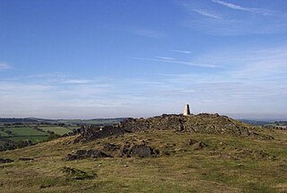
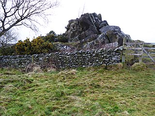
Charnwood Forest is a hilly tract in north-western Leicestershire, England, bounded by Leicester, Loughborough and Coalville. The area is undulating, rocky and picturesque, with barren areas. It also has some extensive tracts of woodland; its elevation is generally 600 feet (180 m) and upwards, the area exceeding this height being about 6,100 acres (25 km2). The highest point, Bardon Hill, is 912 feet (278 m). On its western flank lies an abandoned coalfield, with Coalville and other former mining villages, now being regenerated and replanted as part of the National Forest. The M1 motorway, between junctions 22 and 23, cuts through Charnwood Forest.
The Leicestershire and Rutland Wildlife Trust (LRWT) is one of 46 wildlife trusts across the United Kingdom. It manages nature reserves in Leicestershire and Rutland, and was founded in 1956 as the Leicestershire and Rutland Trust for Nature Conservation. As of January 2018, it has over 16,000 members, a staff of about 25 and more than 500 volunteers. It is based in Leicester, and is managed by a Council of Trustees which is elected by the members. It is a charity which covers all aspects of nature conservation, and works to protect wild places and wildlife.

Windsor Hill is a 61.8-hectare (153-acre) biological Site of Special Scientific Interest in Princes Risborough in Buckinghamshire. It lies within the Chilterns Area of Outstanding Natural Beauty, and it is featured in the Nature Conservation Review. A small part is managed by the Berkshire, Buckinghamshire and Oxfordshire Wildlife Trust, and access to this area requires a permit.

Long Dole Wood and Meadows SSSI is a 9.8 hectares biological Site of Special Scientific Interest (SSSI) between the villages of Farrington Gurney and Hinton Blewitt in Bath and North East Somerset, notified in 1987.

Lower Woods is a 280.1-hectare (692-acre) biological and geological Site of Special Scientific Interest near the village of Wickwar, South Gloucestershire, notified in 1966 and renotified in 1985. The site area has increased at last revision in 1974 to a 284.1-hectare (702-acre) site. The site is a nature reserve managed by the Gloucestershire Wildlife Trust.

Midger is a 65.7-hectare (162-acre) biological Site of Special Scientific Interest straddling the border of Gloucestershire and South Gloucestershire, notified in 1966 and renotified in 1984. Since the last revision in 1974, the size has been reduced to a 56-hectare (140-acre) site. It lies east of Hillesley, Gloucestershire and north of Hawkesbury Upton, South Gloucestershire. It is at the head of the Kilcott Valley.

Dimminsdale is a 37 hectare geological biological and Site of Special Scientific Interest partly in Derbyshire and partly in Leicestershire. It is located east of Calke in Derbyshire. It is a Geological Conservation Review site, and a area of 23.5 hectares is owned by Severn Trent Water and managed by the Leicestershire and Rutland Wildlife Trust.
Fancott Woods and Meadows is a 13.3-hectare Site of Special Scientific Interest near the hamlet of Fancott in Bedfordshire. It was notified under Section 28 of the Wildlife and Countryside Act 1981, and the local planning authority is Central Bedfordshire Council. The site is managed by the Wildlife Trust for Bedfordshire, Cambridgeshire and Northamptonshire.

Brassey is a 2.1-hectare (5.2-acre) biological Site of Special Scientific Interest in Gloucestershire, notified in 1954 and renotified in 1983. It is situated on the north side of the Windrush Valley, midway between Naunton and Upper Slaughter. The reserve comprises sloping, unimproved limestone pasture. There is a fast-flowing stream. This site is one of the few freshwater marshes in Gloucestershire. The stream joins the River Windrush.

Daneway Banks is a 17-hectare (42-acre) biological Site of Special Scientific Interest in Gloucestershire, notified in 1954 and renotified in 1983. It lies half a mile west of Sapperton and is part of a group of wildlife sites in the Frome Valley that includes Siccaridge Wood and Sapperton Canal reserves. The site is in the Cotswold Area of Outstanding Natural Beauty.

Blo' Norton and Thelnetham Fens are a 21.3-hectare (53-acre) biological Site of Special Scientific Interest (SSSI) on the Norfolk/Suffolk border. Blo' Norton Fen is in the parish of Blo' Norton in Norfolk and Thelnetham Fen is in Thelnetham parish in Suffolk. It is a Nature Conservation Review site, Grade 2, and part of the Waveney and Little Ouse Valley Fens Special Area of Conservation, Thelnetham Fen is managed by the Suffolk Wildlife Trust and Blo' Norton Fen by the Little Ouse Headwaters Project (LOHP).
Puckham Woods is a 32.38-hectare (80.0-acre) biological Site of Special Scientific Interest in Gloucestershire to the east of Cheltenham near Whittington, notified in 1954. The site is listed in the 'Cotswold District' Local Plan 2001-2011 as a Key Wildlife Site (KWS).

Alpine Meadow is a 0.4 hectare nature reserve near Berkhamsted in Hertfordshire in the United Kingdom. It is a designated biological Site of Special Scientific Interest (SSSI), managed by the Hertfordshire and Middlesex Wildlife Trust and the planning authority is Dacorum Borough Council.
Cribb's Meadow is a 4.2-hectare (10-acre) nature reserve east of Wymondham in Leicestershire. It is owned and managed by the Leicestershire and Rutland Wildlife Trust, and is designated a biological Site of Special Scientific Interest under the name Cribb's Lodge Meadows. It is also a National Nature Reserve and a Nature Conservation Review site, Grade 2.
Merry's Meadows is a 12.4-hectare (31-acre) nature reserve west of Stretton in Rutland. It is managed by the Leicestershire and Rutland Wildlife Trust, and is a biological Site of Special Scientific Interest under the name Greetham Meadows.

Great Merrible Wood is a 12 hectare nature reserve east of Hallaton in Leicestershire. It is owned and managed by the Leicestershire and Rutland Wildlife Trust, and is part of the Eye Brook Valley Woods Site of Special Scientific Interest.
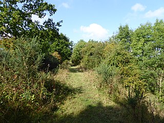
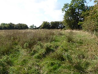
Wymondham Rough is a 6.0 hectares biological Site of Special Scientific Interest (SSSI) east of Stapleford in Leicestershire. The SSSI is part of the 12.5 hectare Wymondham Rough nature reserve, which is managed by the Leicestershire and Rutland Wildlife Trust.

Lea Meadows is a 12-hectare (30-acre) nature reserve east of Markfield in Leicestershire. It is owned and managed by the Leicestershire and Rutland Wildlife Trust. It is part of the Ulverscroft Valley, which is a Site of Special Scientific Interest, and part of it is a scheduled monument.

Ulverscroft is a 56-hectare (140-acre) nature reserve north of Markfield in Leicestershire, England. It is managed by the Leicestershire and Rutland Wildlife Trust (LRWT) and part of it is owned by the National Trust and part by the LRWT. The site is partly in Ulverscroft Valley, which is a Site of Special Scientific Interest.
